File:Édifice du Marché, 182, rue Jacques-Cartier Nord, Saint-Jean-sur-Richelieu Saint-Jean vue d'ensemble face latérale gauche et façade 11-d.na.civile-78-6971.jpg
Jump to navigation
Jump to search

Size of this preview: 386 × 600 pixels. Other resolutions: 154 × 240 pixels | 309 × 480 pixels | 965 × 1,500 pixels.
Original file (965 × 1,500 pixels, file size: 775 KB, MIME type: image/jpeg)
Captions
Captions
Add a one-line explanation of what this file represents
Summary
Object
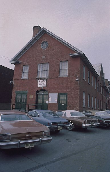
| Français : Édifice du Marché, 182, rue Jacques-Cartier Nord, Saint-Jean-sur-Richelieu (Saint-Jean) : vue d'ensemble face latérale gauche et façade
( |
|||||||||||||||||||||
|---|---|---|---|---|---|---|---|---|---|---|---|---|---|---|---|---|---|---|---|---|---|
| Title |
Français : Édifice du Marché, 182, rue Jacques-Cartier Nord, Saint-Jean-sur-Richelieu (Saint-Jean) : vue d'ensemble face latérale gauche et façade |
||||||||||||||||||||
| Description |
Français : Autres titres : Place du marché de Saint-Jean;182, rue Jacques-Cartier Nord, Saint-Jean-sur-Richelieu. Description : L'édifice autrefois appelé Place du Marché a été construit en 1858 selon les plans de l'architecte Ryder à la demande des citoyens. Les habitants de Saint-Jean désirent un marché couvert et permanent pour remplacer le Butcher's Hall. L'édifice sert de marché aux bouchers, mais il accueille également diverses activités (concerts, bazars, séances du conseil municipal). Le pignon tourné vers la rue et la composition symétrique de la façade rattachent cet édifice au courant néoclassique qui connaît une grande popularité pour les édifices publics bâtis durant la première moitié du 19e siècle. L'immeuble se compose d'un corps de bâtiment de plan rectangulaire à deux étages et demi, d'une toiture à deux versants droits et d'un parvis. (Source : http://www.maculture.ca/edifices-remarquables/place-marche-de-saint-jean/ ) |
||||||||||||||||||||
| Date |
Français : 1858 |
||||||||||||||||||||
| Medium | color photography | ||||||||||||||||||||
| Dimensions | height: 5 cm (1.9 in); width: 5 cm (1.9 in) | ||||||||||||||||||||
| Collection |
|
||||||||||||||||||||
| Current location |
|
||||||||||||||||||||
| Accession number |
11-d.na.civile-78-6971 |
||||||||||||||||||||
| Notes |
Français : Image réalisée sous la direction de Luc Noppen dans le cadre des travaux du Groupe de recherche en art du Québec (GRAQ) vers 1978. |
||||||||||||||||||||

Photograph
| Date | |||||||||||||||||||||||||||
| Source |
|
||||||||||||||||||||||||||
| Author | Groupe de recherche en art du Québec | ||||||||||||||||||||||||||
| Permission (Reusing this file) |
This file is licensed under the Creative Commons Attribution-Share Alike 4.0 International license.
|
||||||||||||||||||||||||||

File history
Click on a date/time to view the file as it appeared at that time.
| Date/Time | Thumbnail | Dimensions | User | Comment | |
|---|---|---|---|---|---|
| current | 15:05, 21 May 2021 | | 965 × 1,500 (775 KB) | Cephas (talk | contribs) | pattypan 20.04 |
You cannot overwrite this file.
File usage on Commons
The following page uses this file: