File:ÉvolutionPopulationIsraéliteFerI.jpg
Jump to navigation
Jump to search

Size of this preview: 568 × 600 pixels. Other resolutions: 227 × 240 pixels | 455 × 480 pixels | 728 × 768 pixels | 970 × 1,024 pixels | 1,940 × 2,048 pixels | 3,380 × 3,568 pixels.
Original file (3,380 × 3,568 pixels, file size: 1.32 MB, MIME type: image/jpeg)
Captions
Captions
Add a one-line explanation of what this file represents
Summary
[edit]
| Description |
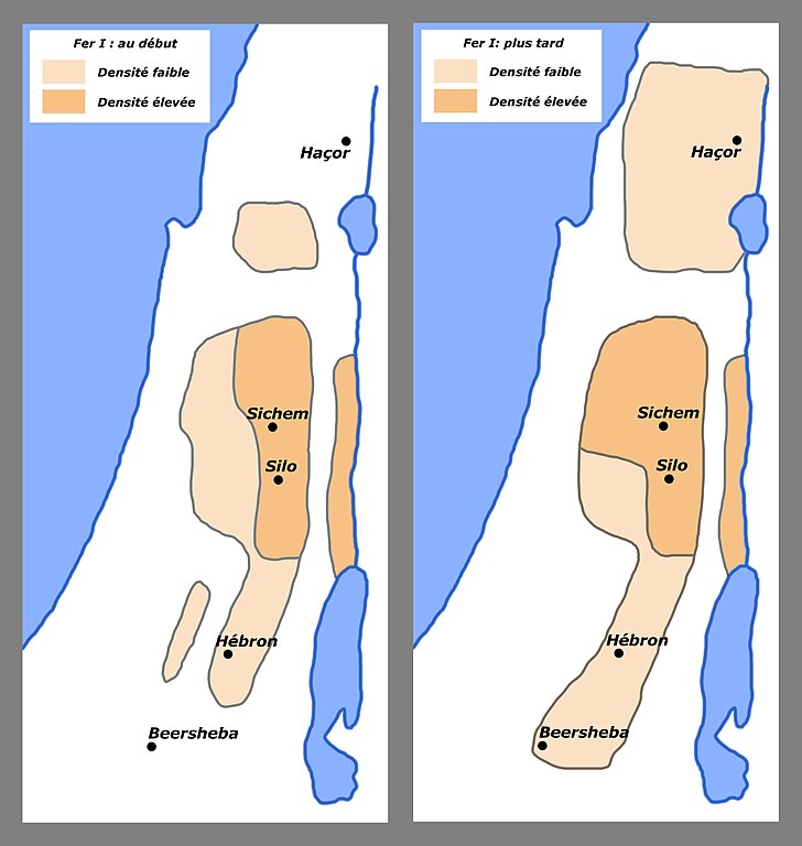
Français : Deux cartes de densité montant l’évolution de la population des Israélites au Fer I Dessiné d’après deux cartes d’Israël Finkelstein, The Archaeology of the Israelite Settlement, Brill Academic Pub, (April 1988), p.325 et p.329. English: Two density maps showing the spread of the Israelites population at Iron I age. Drawn from two maps by Israël Finkelstein, The Archaeology of the Israelite Settlement, Brill Academic Pub, (April 1988), p.325 et p.329. |
| Date | |
| Source | Own work |
| Author | Claude Valette |
Licensing
[edit]
I, the copyright holder of this work, hereby publish it under the following license:
This file is licensed under the Creative Commons Attribution-Share Alike 4.0 International license.
- You are free:
- to share – to copy, distribute and transmit the work
- to remix – to adapt the work
- Under the following conditions:
- attribution – You must give appropriate credit, provide a link to the license, and indicate if changes were made. You may do so in any reasonable manner, but not in any way that suggests the licensor endorses you or your use.
- share alike – If you remix, transform, or build upon the material, you must distribute your contributions under the same or compatible license as the original.
File history
Click on a date/time to view the file as it appeared at that time.
| Date/Time | Thumbnail | Dimensions | User | Comment | |
|---|---|---|---|---|---|
| current | 08:51, 27 April 2015 | | 3,380 × 3,568 (1.32 MB) | Claude Valette (talk | contribs) | User created page with UploadWizard |
You cannot overwrite this file.
File usage on Commons
There are no pages that use this file.
File usage on other wikis
The following other wikis use this file:
- Usage on fr.wikipedia.org