File:Żabnica (Bodek) map.png
Jump to navigation
Jump to search

Size of this preview: 601 × 599 pixels. Other resolutions: 241 × 240 pixels | 481 × 480 pixels | 770 × 768 pixels | 1,027 × 1,024 pixels | 2,054 × 2,048 pixels | 3,068 × 3,059 pixels.
Original file (3,068 × 3,059 pixels, file size: 960 KB, MIME type: image/png)
Captions
Captions
Add a one-line explanation of what this file represents
Summary
[edit]_map.png&action=edit§ion=1)
| Description |
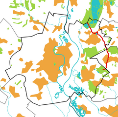
Polski: Mapa Raciborza z zaznaczoną na czerwono strugą Żabnica (potocznie Bodek). |
| Source | Own work |
| Author | Olos88 |
Licensing
[edit]_map.png&action=edit§ion=2)
| I, the copyright holder of this work, release this work into the public domain. This applies worldwide. In some countries this may not be legally possible; if so: I grant anyone the right to use this work for any purpose, without any conditions, unless such conditions are required by law. |
File history
Click on a date/time to view the file as it appeared at that time.
| Date/Time | Thumbnail | Dimensions | User | Comment | |
|---|---|---|---|---|---|
| current | 19:44, 13 January 2011 | | 3,068 × 3,059 (960 KB) | Olos88 (talk | contribs) | {{Information |Description={{pl|1=Mapa Raciborza z zaznaczoną na czerwono strugą Żabnica (potocznie Bodek).}} |Source={{own}} |Author=Olos88 |Date= |Permission= |other_versions= }} Category:Maps of Racibórz [[Category:Żabnica (Ł |
You cannot overwrite this file.
File usage on Commons
The following page uses this file:
File usage on other wikis
The following other wikis use this file:
- Usage on pl.wikipedia.org
_map.png&oldid=450493460)