File:Айрон-Боттом-Саунд.svg
Jump to navigation
Jump to search

Size of this PNG preview of this SVG file: 744 × 600 pixels. Other resolutions: 298 × 240 pixels | 595 × 480 pixels | 953 × 768 pixels | 1,270 × 1,024 pixels | 2,540 × 2,048 pixels | 914 × 737 pixels.
Original file (SVG file, nominally 914 × 737 pixels, file size: 546 KB)
Captions
Captions
Add a one-line explanation of what this file represents
| Description |
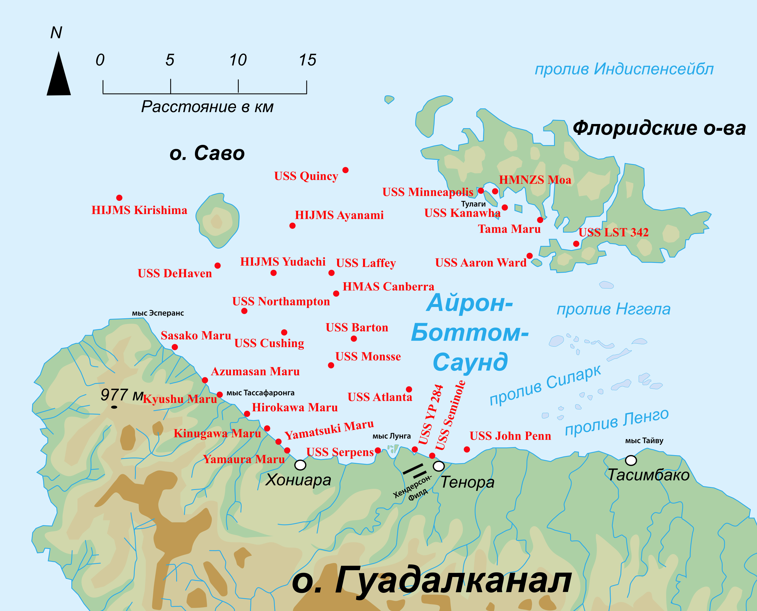
English: Map of the location of shipwrecks in the Ironbottom Sound in the Solomon Islands. Русский: Карта расположения рэков в проливе Айрон-Боттом-Саунд |
| Date | (UTC) |
| Source | |
| Author |
|
| Other versions | Derivative works of this file: Саво, Нггела и окрестности.svg |
This file is licensed under the Creative Commons Attribution-Share Alike 3.0 Unported license.
- You are free:
- to share – to copy, distribute and transmit the work
- to remix – to adapt the work
- Under the following conditions:
- attribution – You must give appropriate credit, provide a link to the license, and indicate if changes were made. You may do so in any reasonable manner, but not in any way that suggests the licensor endorses you or your use.
- share alike – If you remix, transform, or build upon the material, you must distribute your contributions under the same or compatible license as the original.
Original upload log
[edit]
This image is a derivative work of the following images:
- File:Solomon_island_-_Guadalcanal_-_Florida_map-ru.svg licensed with Cc-by-sa-3.0,2.5,2.0,1.0, GFDL
- 2010-04-08T13:00:19Z Vasyatka1 533x449 (186915 Bytes) {{Information |Description={{fr|Carte topographique de l'île de Guadalcanal et des îles Florida parmi les îles Salomon}} {{en|Topographic map of Guadlcanal island and Florida island in Solomon Island}} {{ru|Топогра�
- File:Wrecks_in_the_Ironbottom_Sound.jpg licensed with Cc-by-sa-3.0-migrated, GFDL
- 2005-06-04T14:41:18Z Vvulto 1541x1054 (209997 Bytes) Map of the location of shipwrecks in the [[Ironbottom Sound]] in the [[Solomon Islands]]. [[Category:Solomon Islands]] {{GFDL}}
Uploaded with derivativeFX
File history
Click on a date/time to view the file as it appeared at that time.
| Date/Time | Thumbnail | Dimensions | User | Comment | |
|---|---|---|---|---|---|
| current | 09:20, 9 April 2010 | | 914 × 737 (546 KB) | Vasyatka1 (talk | contribs) | Just made a relief smoother. |
| 09:06, 9 April 2010 |  | 914 × 737 (535 KB) | Vasyatka1 (talk | contribs) | Just made the rivers smoother | |
| 08:34, 9 April 2010 |  | 914 × 737 (524 KB) | Vasyatka1 (talk | contribs) | {{Information |Description={{en|Map of the location of shipwrecks in the Ironbottom Sound in the Solomon Islands.}} {{ru|Карта расположения рэков в проливе Айрон-Боттом-Саун� |
You cannot overwrite this file.
File usage on Commons
There are no pages that use this file.
File usage on other wikis
The following other wikis use this file:
- Usage on az.wikipedia.org
- Usage on ru.wikipedia.org