File:Букобайские яры, Соль-Илецкий район, Оренбургская область.jpg
From Wikimedia Commons, the free media repository
Jump to navigation
Jump to search
![File:Букобайские яры, Соль-Илецкий район, Оренбургская область.jpg](https://upload.wikimedia.org/wikipedia/commons/thumb/0/02/%D0%91%D1%83%D0%BA%D0%BE%D0%B1%D0%B0%D0%B9%D1%81%D0%BA%D0%B8%D0%B5_%D1%8F%D1%80%D1%8B%2C_%D0%A1%D0%BE%D0%BB%D1%8C-%D0%98%D0%BB%D0%B5%D1%86%D0%BA%D0%B8%D0%B9_%D1%80%D0%B0%D0%B9%D0%BE%D0%BD%2C_%D0%9E%D1%80%D0%B5%D0%BD%D0%B1%D1%83%D1%80%D0%B3%D1%81%D0%BA%D0%B0%D1%8F_%D0%BE%D0%B1%D0%BB%D0%B0%D1%81%D1%82%D1%8C.jpg/740px-%D0%91%D1%83%D0%BA%D0%BE%D0%B1%D0%B0%D0%B9%D1%81%D0%BA%D0%B8%D0%B5_%D1%8F%D1%80%D1%8B%2C_%D0%A1%D0%BE%D0%BB%D1%8C-%D0%98%D0%BB%D0%B5%D1%86%D0%BA%D0%B8%D0%B9_%D1%80%D0%B0%D0%B9%D0%BE%D0%BD%2C_%D0%9E%D1%80%D0%B5%D0%BD%D0%B1%D1%83%D1%80%D0%B3%D1%81%D0%BA%D0%B0%D1%8F_%D0%BE%D0%B1%D0%BB%D0%B0%D1%81%D1%82%D1%8C.jpg?20220523120410)
Size of this preview: 740 × 600 pixels. Other resolutions: 296 × 240 pixels | 592 × 480 pixels | 948 × 768 pixels | 1,264 × 1,024 pixels | 2,527 × 2,048 pixels | 3,000 × 2,431 pixels.
Original file (3,000 × 2,431 pixels, file size: 1.61 MB, MIME type: image/jpeg)
File information
Structured data
Captions
Captions
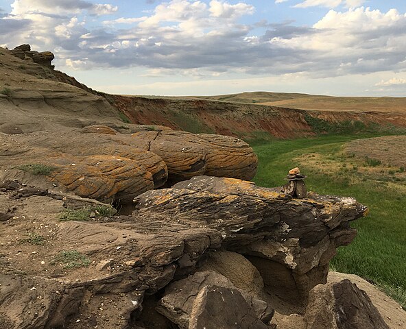
Bukobay Yars, Sol-Iletsk District, Orenburg Region
Summary
[edit]DescriptionБукобайские яры, Соль-Илецкий район, Оренбургская область.jpg |
English: Bukobay Yars - Sandstones in the northern part of the Sol-Iletsk region occupy an area of more than 135 hectares. It is believed that they acquired their unusual spherical shape due to the gradual weathering of rocks. And the color is due to the iron hydroxide that is part of manganese and calcite. In some places there are also layers of clay of variegated colors, bones of ancient vertebrates of the Mesozoic era.
English: Bukobay Yars - Sandstones in the northern part of the Sol-Iletsk region occupy an area of more than 135 hectares. It is believed that they acquired their unusual spherical shape due to the gradual weathering of rocks. And the color is due to the iron hydroxide that is part of manganese and calcite. In some places there are also layers of clay of variegated colors, bones of ancient vertebrates of the Mesozoic era. |
Date | |
Source | Own work |
Author | Lorandy |
Camera location | 51° 26′ 28.18″ N, 55° 26′ 57.61″ E ![]() ![]() | View this and other nearby images on: OpenStreetMap | ![]() |
---|
Licensing
[edit]I, the copyright holder of this work, hereby publish it under the following license:
![w:en:Creative Commons](https://upload.wikimedia.org/wikipedia/commons/thumb/7/79/CC_some_rights_reserved.svg/90px-CC_some_rights_reserved.svg.png)
![attribution](https://upload.wikimedia.org/wikipedia/commons/thumb/1/11/Cc-by_new_white.svg/24px-Cc-by_new_white.svg.png)
This file is licensed under the Creative Commons Attribution 4.0 International license.
- You are free:
- to share – to copy, distribute and transmit the work
- to remix – to adapt the work
- Under the following conditions:
- attribution – You must give appropriate credit, provide a link to the license, and indicate if changes were made. You may do so in any reasonable manner, but not in any way that suggests the licensor endorses you or your use.
![]() |
This image was uploaded as part of Russian Science Photo Competition 2022.
|
File history
Click on a date/time to view the file as it appeared at that time.
Date/Time | Thumbnail | Dimensions | User | Comment | |
---|---|---|---|---|---|
current | 12:04, 23 May 2022 | ![]() | 3,000 × 2,431 (1.61 MB) | Lorandy (talk | contribs) | Uploaded own work with UploadWizard |
You cannot overwrite this file.
File usage on Commons
There are no pages that use this file.
Metadata
This file contains additional information such as Exif metadata which may have been added by the digital camera, scanner, or software program used to create or digitize it. If the file has been modified from its original state, some details such as the timestamp may not fully reflect those of the original file. The timestamp is only as accurate as the clock in the camera, and it may be completely wrong.
Camera manufacturer | Apple |
---|---|
Camera model | iPhone 6s |
Exposure time | 1/553 sec (0.0018083182640145) |
F-number | f/2.2 |
ISO speed rating | 25 |
Date and time of data generation | 19:54, 6 June 2020 |
Lens focal length | 4.15 mm |
Latitude | 51° 26′ 28.18″ N |
Longitude | 55° 26′ 57.61″ E |
Altitude | 154.843 meters above sea level |
Orientation | Normal |
Horizontal resolution | 72 dpi |
Vertical resolution | 72 dpi |
Software used | Windows Photo Editor 10.0.10011.16384 |
File change date and time | 16:52, 23 May 2022 |
Y and C positioning | Centered |
Exposure Program | Normal program |
Exif version | 2.31 |
Date and time of digitizing | 19:54, 6 June 2020 |
Meaning of each component |
|
APEX shutter speed | 9.1113896129938 |
APEX aperture | 2.2750070475475 |
APEX brightness | 8.5135371179039 |
APEX exposure bias | 0 |
Metering mode | Pattern |
Flash | Flash did not fire, compulsory flash suppression |
DateTimeOriginal subseconds | 881 |
DateTimeDigitized subseconds | 881 |
Supported Flashpix version | 1 |
Color space | sRGB |
Sensing method | One-chip color area sensor |
Scene type | A directly photographed image |
Exposure mode | Auto exposure |
White balance | Auto white balance |
Focal length in 35 mm film | 29 mm |
Scene capture type | Standard |
Speed unit | Kilometers per hour |
Speed of GPS receiver | 0 |
Reference for direction of image | True direction |
Direction of image | 17.435230250842 |
Reference for bearing of destination | True direction |
Bearing of destination | 17.435230250842 |
GPS date | 6 June 2020 |
Structured data
Items portrayed in this file
depicts
some value
51°26'28.180"N, 55°26'57.610"E
0.00180831826401446654 second
2.2
4.15 millimetre
image/jpeg
Hidden categories: