File:Карта Бессарабии из атласа 1940.png
Jump to navigation
Jump to search

Size of this preview: 534 × 599 pixels. Other resolutions: 214 × 240 pixels | 428 × 480 pixels | 899 × 1,009 pixels.
Original file (899 × 1,009 pixels, file size: 1.61 MB, MIME type: image/png)
Captions
Captions
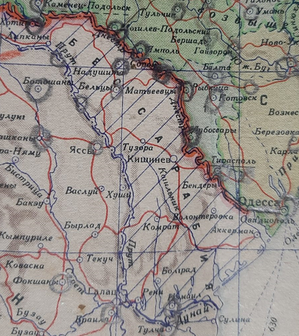
Map of Bessarabia from a Soviet atlas, 1940.
Summary
[edit]
| Description |
English: Map of Bessarabia from the Soviet atlas, 1940. However, this atlas was used by veterans of World War II, so some military symbols remained there. The value of the map is in the shading of Bessarabia, which indicates Soviet claims to this region.
Русский: Карта Бессарабии из советского атласа, 1940. Правда, этот атлас был в пользовании у ветераны Второй мировой войны, поэтому там остались некоторые военные обозначения. Ценность карты в штриховке Бессарабии, что говорит о советских претензиях на этот регион. |
| Date | |
| Source | Карманный атлас мира, СССР, 1940. |
| Author | ГУГиК при СНК СССР |
Licensing
[edit]
|
This work is in the public domain in its country of origin and other countries and areas where the copyright term is the author's life plus 70 years or fewer. | |
| This file has been identified as being free of known restrictions under copyright law, including all related and neighboring rights. | |
File history
Click on a date/time to view the file as it appeared at that time.
| Date/Time | Thumbnail | Dimensions | User | Comment | |
|---|---|---|---|---|---|
| current | 14:36, 13 May 2024 | | 899 × 1,009 (1.61 MB) | Maksak Timofey (talk | contribs) | Uploaded a work by ГУГиК при СНК СССР from Карманный атлас мира, СССР, 1940. with UploadWizard |
You cannot overwrite this file.
File usage on Commons
There are no pages that use this file.
File usage on other wikis
The following other wikis use this file:
- Usage on ru.wikipedia.org