File:Карта Кольского полуострова от Кандалакши до плотины Нива.jpg
Jump to navigation
Jump to search

Size of this preview: 439 × 600 pixels. Other resolutions: 176 × 240 pixels | 351 × 480 pixels | 562 × 768 pixels | 749 × 1,024 pixels | 2,550 × 3,484 pixels.
Original file (2,550 × 3,484 pixels, file size: 1.14 MB, MIME type: image/jpeg)
Captions
Captions
Add a one-line explanation of what this file represents
| Description |
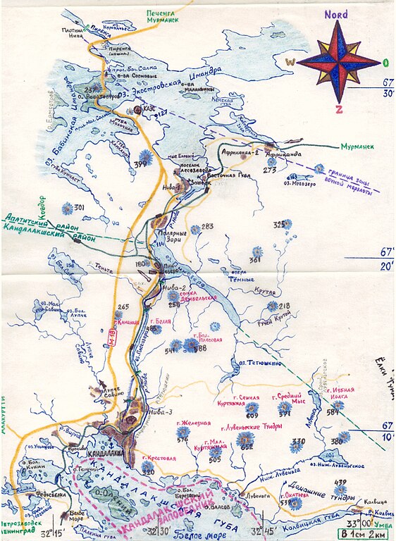
Русский: План-двухкилометровка Кольского полуострова от Кандалакши до плотины Нива ГЭС по состоянию на 1980-е годы. В середине карты сверху вниз Кольская атомная электростанция, Полярные Зори, посёлки Нивский-1, -2, -3, Кандалакша.
|
| Date | 1990-е |
| Source | Own work by Victor Vizu - picture and scan (собственноручно нарисованный рисунок), сканирование - 2008 год. |
| Author | Victor Vizu |
| Permission (Reusing this file) |
This file is licensed under the Creative Commons Attribution-Share Alike 3.0 Unported license.
|
File history
Click on a date/time to view the file as it appeared at that time.
| Date/Time | Thumbnail | Dimensions | User | Comment | |
|---|---|---|---|---|---|
| current | 22:03, 8 July 2009 | | 2,550 × 3,484 (1.14 MB) | Insider (talk | contribs) | {{Information |Description={{ru|План-двухкилометровка Кольского полуострова от Кандалакши до плотины Нива ГЭС по состоянию |
You cannot overwrite this file.
File usage on Commons
There are no pages that use this file.
File usage on other wikis
The following other wikis use this file:
- Usage on de.wikipedia.org
- Usage on es.wikipedia.org
- Usage on fi.wikipedia.org
- Usage on hy.wikipedia.org
- Usage on it.wikipedia.org
- Usage on la.wikipedia.org
- Usage on ru.wikipedia.org