File:Пам'ятний знак героя СРСР В. П.Колесника Вставши на повний зріст, єфрейтор В. С. Колесник закрив своїм тілом амбразуру.jpg
Original file (1,181 × 886 pixels, file size: 120 KB, MIME type: image/jpeg)
Captions
Summary[edit]
DescriptionПам'ятний знак героя СРСР В. П.Колесника Вставши на повний зріст, єфрейтор В. С. Колесник закрив своїм тілом амбразуру.jpg |
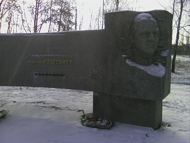
Українська: Пам'ятник Героям Радянського Союзу Колеснику В. С. і Шутьку Є. Й., Борова, сквер Комсомольської слави
|
||
Date | |||
Source | Own work | ||
Author | Іван марущенко |
Camera location | 49° 22′ 24″ N, 37° 37′ 22″ E | View this and other nearby images on: OpenStreetMap | 49.373333; 37.622778 |
---|
Licensing[edit]
- You are free:
- to share – to copy, distribute and transmit the work
- to remix – to adapt the work
- Under the following conditions:
- attribution – You must give appropriate credit, provide a link to the license, and indicate if changes were made. You may do so in any reasonable manner, but not in any way that suggests the licensor endorses you or your use.
- share alike – If you remix, transform, or build upon the material, you must distribute your contributions under the same or compatible license as the original.
This image was uploaded as part of Wiki Loves Monuments 2019.
Afrikaans ∙ Alemannisch ∙ azərbaycanca ∙ Bahasa Indonesia ∙ Bahasa Melayu ∙ Bikol Central ∙ bosanski ∙ brezhoneg ∙ català ∙ čeština ∙ Cymraeg ∙ dansk ∙ davvisámegiella ∙ Deutsch ∙ eesti ∙ English ∙ español ∙ Esperanto ∙ euskara ∙ français ∙ Frysk ∙ Gaeilge ∙ galego ∙ hrvatski ∙ Ido ∙ italiano ∙ latviešu ∙ Lëtzebuergesch ∙ Malagasy ∙ magyar ∙ Malti ∙ Nederlands ∙ norsk ∙ norsk nynorsk ∙ norsk bokmål ∙ polski ∙ português ∙ português do Brasil ∙ română ∙ shqip ∙ sicilianu ∙ slovenčina ∙ slovenščina ∙ suomi ∙ svenska ∙ Tagalog ∙ Türkçe ∙ Yorùbá ∙ Zazaki ∙ Ελληνικά ∙ беларуская ∙ беларуская (тарашкевіца) ∙ български ∙ кыргызча ∙ македонски ∙ русский ∙ српски / srpski ∙ українська ∙ ქართული ∙ հայերեն ∙ नेपाली ∙ हिन्दी ∙ বাংলা ∙ മലയാളം ∙ ไทย ∙ 한국어 ∙ +/− |
File history
Click on a date/time to view the file as it appeared at that time.
Date/Time | Thumbnail | Dimensions | User | Comment | |
---|---|---|---|---|---|
current | 16:20, 19 September 2019 | 1,181 × 886 (120 KB) | Іван марущенко (talk | contribs) | User created page with UploadWizard |
You cannot overwrite this file.
File usage on Commons
The following page uses this file:
File usage on other wikis
The following other wikis use this file:
- Usage on uk.wikipedia.org
Metadata
This file contains additional information such as Exif metadata which may have been added by the digital camera, scanner, or software program used to create or digitize it. If the file has been modified from its original state, some details such as the timestamp may not fully reflect those of the original file. The timestamp is only as accurate as the clock in the camera, and it may be completely wrong.
Image title | Jpeg |
---|---|
Camera manufacturer | Android |
Camera model | Nomi C08000 |
Exposure time | 1/1,000 sec (0.001) |
F-number | f/2.4 |
ISO speed rating | 36 |
Date and time of data generation | 10:36, 2 December 2016 |
Lens focal length | 4.39 mm |
Latitude | 49° 22′ 24″ N |
Longitude | 37° 37′ 22″ E |
Altitude | 113 meters above sea level |
Width | 1,600 px |
Height | 1,200 px |
Orientation | Normal |
Horizontal resolution | 72 dpi |
Vertical resolution | 72 dpi |
Software used | Android |
File change date and time | 10:36, 2 December 2016 |
Y and C positioning | Centered |
Exposure Program | Aperture priority |
Exif version | 2.2 |
Date and time of digitizing | 10:36, 2 December 2016 |
Meaning of each component |
|
APEX shutter speed | 9 |
APEX aperture | 2 |
APEX exposure bias | 0 |
Maximum land aperture | 2 APEX (f/2) |
Metering mode | Center weighted average |
Light source | Unknown |
Flash | Flash did not fire |
Supported Flashpix version | 1 |
Color space | sRGB |
Exposure mode | Auto exposure |
White balance | Auto white balance |
Digital zoom ratio | 0 |
Scene capture type | Standard |
Scene control | None |
Contrast | Normal |
Saturation | Normal |
Sharpness | Normal |
GPS time (atomic clock) | 08:35 |
Reference for direction of image | Magnetic direction |
Direction of image | 0 |
GPS date | 2 December 2016 |
GPS tag version | 2.2.0.0 |
Structured data
Items portrayed in this file
depicts
2 December 2016
49°22'23.999"N, 37°37'22.001"E
0.001 second
2.4
4.39 millimetre
image/jpeg
- Cultural heritage monuments in Ukraine with known IDs
- Cultural heritage monuments in Ukraine missing SDC depicts
- Cultural heritage monuments in Ukraine missing SDC location of creation
- Wiki loves monuments in Ukraine 2019 - Quantity
- Files with coordinates missing SDC location of creation
- CC-BY-SA-4.0
- Self-published work
- Images from Wiki Loves Monuments 2019
- Images from Wiki Loves Monuments 2019 in Ukraine
- Images from Wiki Loves Monuments missing SDC depicts
- Images from Wiki Loves Monuments missing SDC location of creation
- Uploaded via Campaign:wlm-ua
- Taken with Nomi Libra
- Ukraine photographs taken on 2016-12-02
- Pages with maps