File:Схема Ингальской долины.jpg
Jump to navigation
Jump to search

Size of this preview: 800 × 592 pixels. Other resolutions: 320 × 237 pixels | 640 × 474 pixels | 1,024 × 758 pixels | 1,280 × 948 pixels | 2,179 × 1,613 pixels.
Original file (2,179 × 1,613 pixels, file size: 541 KB, MIME type: image/jpeg)
Captions
Captions
Add a one-line explanation of what this file represents
Summary[edit]
| Description |
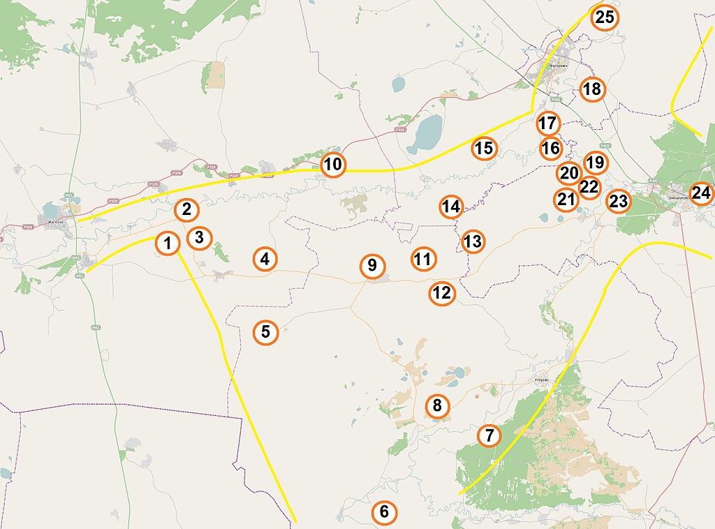
Русский: Приблизительная схема Ингальской долины, создана на основе OpenStreetMap, Схематического плана археологического микрорайона Ингальская долина и книги Волков Е. Н. Комплекс археологических памятников Ингальская долина. — Новосибирск: Наука, 2007. — 224 с. — 500 экз. — ISBN 978-5-02-031090-2. Цифрами обозначены: 1 - Марьино ущелье, 2 - Красногорский археотоп (Хрипуновский могильник, Лизуново городище), 3 – Коловский, 4 – Верхне-Ингальский Борок, 5 – Липихинское, 6 – Боровушки, 7 – Скородум, 8 – Тютринский могильник , 9 – Ингалинское, 10 – Слободо-Бешкильское городище, 11 – Нижнеингалинское, 12 – Пушкарёво, 13 – Ак-Паш, 14 – Сазык, 15 – Сосновка, 16 – Остров, 17 – Бузан, 18 – Имбиряй, 19 – Устюг, 20 – Щетково, 21 – Старо-Лыбаево, 22 – Двухозёрное, 23 – Гилёва, 24 – Ук, 25 - Хохловский курган. |
| Date | |
| Source | OpenStreetMap + Own work |
| Author | Дмитрий Кошелев |
Licensing[edit]
| Description |
This map was created from OpenStreetMap project data, collected by the community. This map may be incomplete, and may contain errors. Don't rely solely on it for navigation. |
|||
| Date | (see file history) | |||
| Source | You may find a page on the OpenStreetMap wiki page for Ингальская долина | |||
| Creator |
OpenStreetMap contributors |
|||
| Permission (Reusing this file) |
OpenStreetMap data is available under the Open Database License (details). Map tiles are licensed under the Creative Commons Attribution-ShareAlike 2.0 license (CC-BY-SA 2.0).
This file is licensed under the Creative Commons Attribution-Share Alike 2.0 Generic license.
|
|||
| Georeferencing | If inappropriate please set warp_status = skip to hide. |
File history
Click on a date/time to view the file as it appeared at that time.
| Date/Time | Thumbnail | Dimensions | User | Comment | |
|---|---|---|---|---|---|
| current | 21:06, 9 February 2013 | | 2,179 × 1,613 (541 KB) | Дмитрий Кошелев (talk | contribs) | Добавлены разрешение и археологические памятники. |
| 05:02, 21 December 2012 |  | 717 × 403 (125 KB) | Дмитрий Кошелев (talk | contribs) | User created page with UploadWizard |
You cannot overwrite this file.
File usage on Commons
The following page uses this file:
File usage on other wikis
The following other wikis use this file:
- Usage on en.wikipedia.org
- Usage on es.wikipedia.org
- Usage on nl.wikipedia.org
- Usage on ru.wikipedia.org
- Usage on www.wikidata.org