File:Схема залізниць сучасної Донецько-Макіївської агломерації станом на 1912 рік.png
Jump to navigation
Jump to search

Size of this preview: 800 × 540 pixels. Other resolutions: 320 × 216 pixels | 640 × 432 pixels | 1,024 × 691 pixels | 1,225 × 827 pixels.
Original file (1,225 × 827 pixels, file size: 1.87 MB, MIME type: image/png)
Captions
Captions
Add a one-line explanation of what this file represents
Summary
[edit]
| Description |
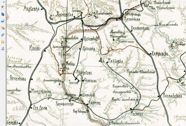
Українська: На схемі - Богодухівська залізнична гілка Ясинувата - Грачове - Мушкетове - Караванна - Доля |
| Date | рік |
| Source | По Екатерининской железной дороге. Вып. ІІ. - Екатеринослав, 1912 |
| Author | Катерининська залізниця |
Licensing
[edit]
|
This work is in the public domain in its country of origin and other countries and areas where the copyright term is the author's life plus 70 years or fewer. This work is in the public domain in the United States because it was published (or registered with the U.S. Copyright Office) before January 1, 1929. | |
| This file has been identified as being free of known restrictions under copyright law, including all related and neighboring rights. | |
File history
Click on a date/time to view the file as it appeared at that time.
| Date/Time | Thumbnail | Dimensions | User | Comment | |
|---|---|---|---|---|---|
| current | 21:32, 20 April 2020 | | 1,225 × 827 (1.87 MB) | Pavlo belytsky (talk | contribs) | Uploaded a work by Катерининська залізниця from По Екатерининской железной дороге. Вып. ІІ. - Екатеринослав, 1912 with UploadWizard |
You cannot overwrite this file.
File usage on Commons
There are no pages that use this file.