File:Успенська церква (Коробчине). Загальний вигляд.jpg
Jump to navigation
Jump to search

Size of this preview: 450 × 600 pixels. Other resolutions: 180 × 240 pixels | 360 × 480 pixels | 576 × 768 pixels | 768 × 1,024 pixels | 1,445 × 1,926 pixels.
Original file (1,445 × 1,926 pixels, file size: 502 KB, MIME type: image/jpeg)
Captions
Captions
Add a one-line explanation of what this file represents
Summary
[edit]._%D0%97%D0%B0%D0%B3%D0%B0%D0%BB%D1%8C%D0%BD%D0%B8%D0%B9_%D0%B2%D0%B8%D0%B3%D0%BB%D1%8F%D0%B4.jpg&action=edit§ion=1)
| Camera location | | View this and other nearby images on: OpenStreetMap |
|---|
._%D0%97%D0%B0%D0%B3%D0%B0%D0%BB%D1%8C%D0%BD%D0%B8%D0%B9_%D0%B2%D0%B8%D0%B3%D0%BB%D1%8F%D0%B4.jpg¶ms=048.767759_N_0031.494429_E_globe:Earth_type:camera__&language=en)
| Description |
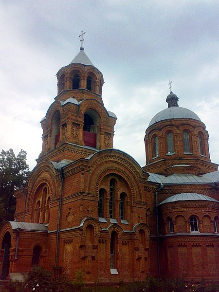
Українська: Загальний вигляд Успенської церкви (Коробчине, Новомиргородський район, Кіровоградська область)
|
||
| Date | |||
| Source | Own work | ||
| Author | Елвіс |
Licensing
[edit]._%D0%97%D0%B0%D0%B3%D0%B0%D0%BB%D1%8C%D0%BD%D0%B8%D0%B9_%D0%B2%D0%B8%D0%B3%D0%BB%D1%8F%D0%B4.jpg&action=edit§ion=2)
I, the copyright holder of this work, hereby publish it under the following license:
This file is licensed under the Creative Commons Attribution-Share Alike 3.0 Unported license.
- You are free:
- to share – to copy, distribute and transmit the work
- to remix – to adapt the work
- Under the following conditions:
- attribution – You must give appropriate credit, provide a link to the license, and indicate if changes were made. You may do so in any reasonable manner, but not in any way that suggests the licensor endorses you or your use.
- share alike – If you remix, transform, or build upon the material, you must distribute your contributions under the same or compatible license as the original.

|
This image was uploaded as part of Wiki Loves Monuments 2012.
|
 |
File history
Click on a date/time to view the file as it appeared at that time.
| Date/Time | Thumbnail | Dimensions | User | Comment | |
|---|---|---|---|---|---|
| current | 09:29, 18 September 2012 | | 1,445 × 1,926 (502 KB) | Елвіс (talk | contribs) | User created page with UploadWizard |
You cannot overwrite this file.
File usage on Commons
The following 5 pages use this file:
File usage on other wikis
The following other wikis use this file:
- Usage on ce.wikipedia.org
- Usage on fr.wikipedia.org
- Usage on hy.wikipedia.org
- Usage on pl.wikipedia.org
- Usage on ro.wikipedia.org
- Usage on ru.wikipedia.org
- Usage on uk.wikipedia.org
- Вікіпедія:Вікі любить пам'ятки/старий АТУ/Кіровоградська область/Новомиргородський район
- Вікіпедія:Проєкт:Тематичний тиждень/Тиждень Кіровоградщини 2
- Вікіпедія:Wiki Loves Monuments/Кіровоградська область/Новомиргородський район
- Вікіпедія:Вікі любить пам'ятки/Кіровоградська область/Новоукраїнський район/Новомиргородська громада
- Usage on www.wikidata.org
._Загальний_вигляд.jpg&oldid=802668928)