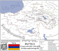
File:Հայաստանի առաջին հանրապետության սահմանները՝ ներառյալ Սևրի պայմանագրով կցված շրջանները.svg

Original file (SVG file, nominally 512 × 436 pixels, file size: 736 KB)
Captions
Captions
Summary
[edit]| DescriptionՀայաստանի առաջին հանրապետության սահմանները՝ ներառյալ Սևրի պայմանագրով կցված շրջանները.svg |
Հայերեն: Հայաստանի առաջին հանրապետության սահմանները՝ ներառյալ Սևրի պայմանագրով կցված շրջանները։
Русский: Границы Первой Республики Армения, включая присоединённые Севрским договором территории.
English: Boundaries of First Republic of Armenia, including the territories stated by Sevres treaty. |
| Date | |
| Source | Own work |
| Author | Hesov |
Licensing
[edit]| This file is made available under the Creative Commons CC0 1.0 Universal Public Domain Dedication. | |
| The person who associated a work with this deed has dedicated the work to the public domain by waiving all of their rights to the work worldwide under copyright law, including all related and neighboring rights, to the extent allowed by law. You can copy, modify, distribute and perform the work, even for commercial purposes, all without asking permission.
http://creativecommons.org/publicdomain/zero/1.0/deed.enCC0Creative Commons Zero, Public Domain Dedicationfalsefalse |
File history
Click on a date/time to view the file as it appeared at that time.
| Date/Time | Thumbnail | Dimensions | User | Comment | |
|---|---|---|---|---|---|
| current | 15:40, 1 May 2024 |  | 512 × 436 (736 KB) | Hesov (talk | contribs) | Ուղղված է քարտեզի սահմանները հատող տեքստը։ |
| 17:35, 30 April 2024 |  | 512 × 436 (651 KB) | Hesov (talk | contribs) | Ուղղված է մարզի անվան մեջ տառի բացակայություն | |
| 14:36, 30 April 2024 |  | 512 × 436 (558 KB) | Hesov (talk | contribs) | Uploaded own work with UploadWizard |
You cannot overwrite this file.
File usage on Commons
There are no pages that use this file.
File usage on other wikis
The following other wikis use this file:
- Usage on hy.wikipedia.org
Metadata
This file contains additional information such as Exif metadata which may have been added by the digital camera, scanner, or software program used to create or digitize it. If the file has been modified from its original state, some details such as the timestamp may not fully reflect those of the original file. The timestamp is only as accurate as the clock in the camera, and it may be completely wrong.
| Width | 100% |
|---|---|
| Height | 100% |