File:みなと村のおよその範囲.png
Jump to navigation
Jump to search

Size of this preview: 800 × 516 pixels. Other resolutions: 320 × 206 pixels | 640 × 413 pixels | 1,093 × 705 pixels.
Original file (1,093 × 705 pixels, file size: 847 KB, MIME type: image/png)
Captions
Captions
Add a one-line explanation of what this file represents
Summary
[edit]| Description |
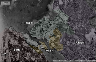
日本語: 米軍撮影・空中写真 1947/05/12 (国土地理院地図・空中写真閲覧サービス USAokinawa-M1000B-109) をもとに作成
みなと村のロケーション参考資料 1. 那覇市パネル「みなと村の役場跡」 (https://www.naha-contentsdb.jp/spot/588) 2. 那覇市「第1巻 通史編 那覇市議会の歩み」pdf (https://www.city.naha.okinawa.jp/sigikai/annai/history.files/vol_1.pdf) |
| Date | 1947/05/12 |
| Source | 国土地理院地図・空中写真閲覧サービス |
| Author | U.S. Military |
Licensing
[edit]
|
The copyright holder of this file, Ministry of Land, Infrastructure, Transport and Tourism, allows anyone to use it for any purpose, provided that the copyright holder is properly attributed. Redistribution, derivative work, commercial use, and all other use is permitted. |
Attribution:
National Land Image Information (Color Aerial Photographs), created by Ministry of Land, Infrastructure, Transport and Tourism, distributed by Geospatial Information Authority of Japan
|

File history
Click on a date/time to view the file as it appeared at that time.
| Date/Time | Thumbnail | Dimensions | User | Comment | |
|---|---|---|---|---|---|
| current | 21:11, 11 March 2022 | | 1,093 × 705 (847 KB) | Alain Parks (talk | contribs) | Uploaded a work by U.S. Military from 国土地理院地図・空中写真閲覧サービス with UploadWizard |
You cannot overwrite this file.
File usage on Commons
There are no pages that use this file.