File:倉敷市 用水路-10 下庄地区(旧・庄村).jpg
Jump to navigation
Jump to search
Size of this preview: 800 × 600 pixels. Other resolutions: 320 × 240 pixels | 640 × 480 pixels | 1,024 × 768 pixels | 1,280 × 960 pixels | 2,560 × 1,920 pixels.
Original file (2,560 × 1,920 pixels, file size: 1.64 MB, MIME type: image/jpeg)
Captions
Captions
Add a one-line explanation of what this file represents
Summary
[edit]
| Description |
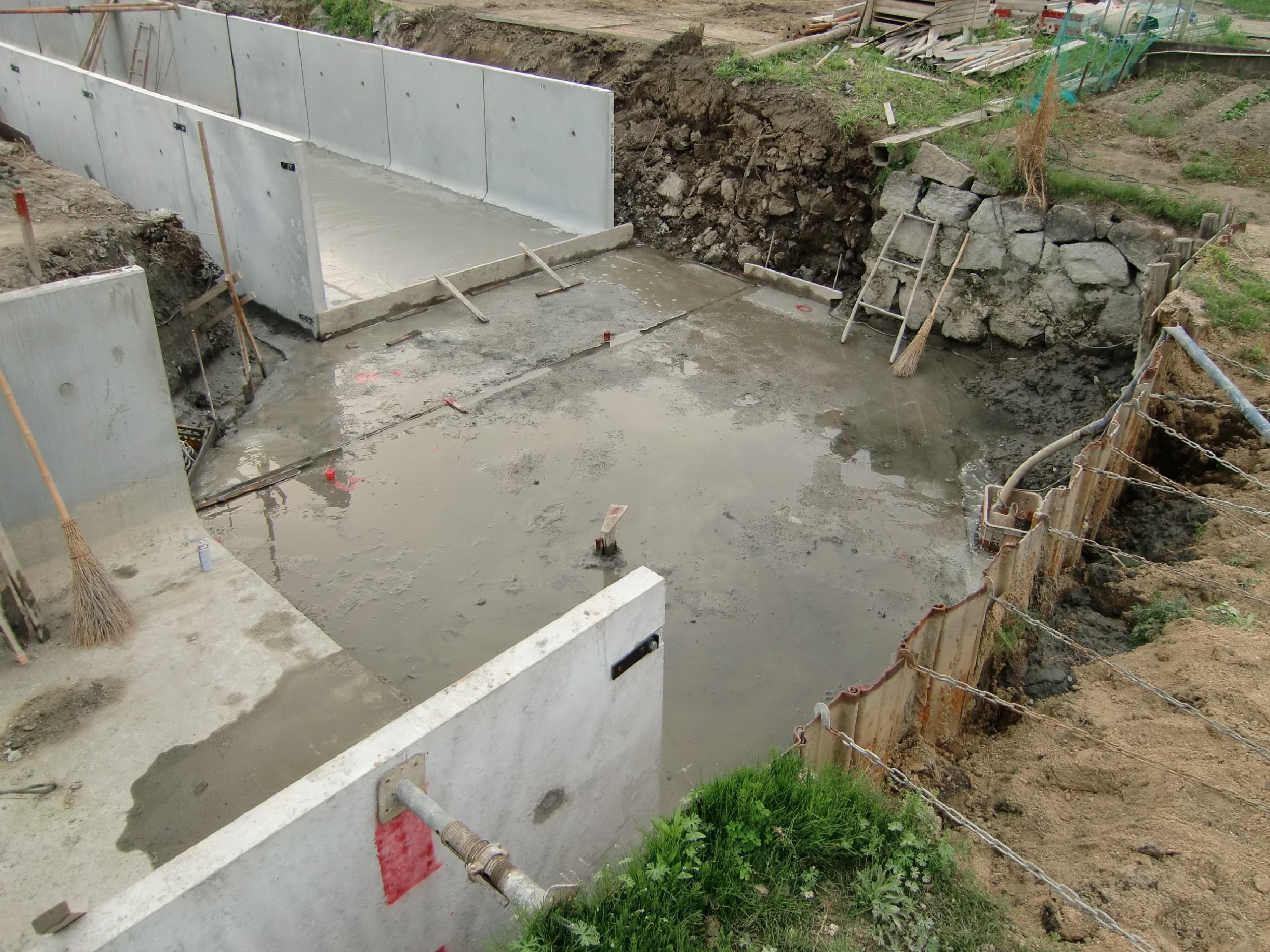
日本語: 川幅の広い基幹水路が、直角に曲がっている荒れた水路を掘り下げて、大規模な改修工事中の風景。
基本的には、画像の左下角側(南側)から流れて右上角側の石垣(宅地跡)にぶつかり、左上角側(西側)に流れているので、石垣の右下側護岸には長年に渡り相当な水圧が掛かり続けていた。 この影響で通常の水田がある右下側護岸は、従来からの木杭と薄板の仮設護岸でしのいでいたものの、水流の関係で特に損傷が激しい部分は、市役所より希望者に支給され続けていた補修用板が、平成の中ごろより従来の厚みと比べて半分程度となった粗末な支給資材で補修しても、複雑な水流で直ぐに朽ちると言いう状況が続いていた。 またこの水路は、北部の上東地区へ送水する複数の基幹水路の一部でもあり、土砂流入による水量の不安定を防ぐためなどの特殊事情により、特に崩落の激しい右側中央上からの部分的に数メートル区間に渡って矢板(鉄板の杭)を打ち込んで、応急的に護岸崩落を防いでいた。 なお、矢板の裏側(水田側)は、川底を一時的に掘り下げた影響で矢板が水路側へ倒れないように、鎖で水田側へ引っ張って補強している。 |
| Date | 2014年4月22日撮影。 |
| Source | Own work |
| Author | 農業土木通信員 |
Licensing
[edit]
I, the copyright holder of this work, hereby publish it under the following license:
This file is licensed under the Creative Commons Attribution-Share Alike 4.0 International license.
- You are free:
- to share – to copy, distribute and transmit the work
- to remix – to adapt the work
- Under the following conditions:
- attribution – You must give appropriate credit, provide a link to the license, and indicate if changes were made. You may do so in any reasonable manner, but not in any way that suggests the licensor endorses you or your use.
- share alike – If you remix, transform, or build upon the material, you must distribute your contributions under the same or compatible license as the original.
File history
Click on a date/time to view the file as it appeared at that time.
| Date/Time | Thumbnail | Dimensions | User | Comment | |
|---|---|---|---|---|---|
| current | 19:20, 14 September 2021 | | 2,560 × 1,920 (1.64 MB) | 農業土木通信員 (talk | contribs) | Uploaded own work with UploadWizard |
You cannot overwrite this file.
File usage on Commons
There are no pages that use this file.
File usage on other wikis
The following other wikis use this file:
- Usage on ja.wikipedia.org
.jpg&oldid=661582363)