File:南部弾薬庫 1970年.png
Jump to navigation
Jump to search

Size of this preview: 646 × 600 pixels. Other resolutions: 259 × 240 pixels | 517 × 480 pixels | 828 × 768 pixels | 1,209 × 1,122 pixels.
Original file (1,209 × 1,122 pixels, file size: 2.24 MB, MIME type: image/png)
Captions
Captions
Add a one-line explanation of what this file represents
Summary
[edit]
| Description |
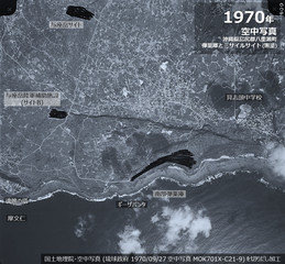
日本語: 返還前の米軍「南部弾薬庫」「与座岳陸軍補助施設 サイトA」「与座岳サイト」
1970年9月27日の空中写真ではミサイルサイトと弾薬庫が黒塗りされている。 |
| Date | |
| Source | 国土地理院地図・空中写真閲覧サービス |
| Author | 国土地理院・空中写真 (琉球政府 1970/09/27 空中写真 MOK701X-C21-9) を切りだし加工 |
Licensing
[edit]

|
This work is licensed under the Government of Japan Standard Terms of Use (Ver.2.0). The Terms of Use are compatible with the Creative Commons Attribution License 4.0 International. For the terms of use of this work, see this license page.
|
This file is licensed under the Creative Commons Attribution 4.0 International license.
Attribution: 国土地理院 (GSI)
- You are free:
- to share – to copy, distribute and transmit the work
- to remix – to adapt the work
- Under the following conditions:
- attribution – You must give appropriate credit, provide a link to the license, and indicate if changes were made. You may do so in any reasonable manner, but not in any way that suggests the licensor endorses you or your use.

|
This media file is uncategorized.
Please help improve this media file by adding it to one or more categories, so it may be associated with related media files (how?), and so that it can be more easily found.
Please notify the uploader with {{subst:Please link images|File:南部弾薬庫 1970年.png}} ~~~~ |
File history
Click on a date/time to view the file as it appeared at that time.
| Date/Time | Thumbnail | Dimensions | User | Comment | |
|---|---|---|---|---|---|
| current | 12:45, 6 October 2022 | | 1,209 × 1,122 (2.24 MB) | Alain Parks (talk | contribs) | error corrected |
| 12:08, 6 October 2022 |  | 1,215 × 1,120 (2.25 MB) | Alain Parks (talk | contribs) | Uploaded a work by 国土地理院・空中写真 (琉球政府 1970/09/27 空中写真 MOK701X-C21-9) を切りだし加工 from 国土地理院地図・空中写真閲覧サービス with UploadWizard |
You cannot overwrite this file.
File usage on Commons
There are no pages that use this file.
File usage on other wikis
The following other wikis use this file:
- Usage on ja.wikipedia.org
- Usage on www.wikidata.org