File:春日浸水營古道(屏東段)-1(Photographs by WEI, WAN-CHEN).jpg
Jump to navigation
Jump to search

Size of this preview: 396 × 599 pixels. Other resolutions: 158 × 240 pixels | 317 × 480 pixels | 507 × 768 pixels | 676 × 1,024 pixels | 1,353 × 2,048 pixels | 3,184 × 4,820 pixels.
Original file (3,184 × 4,820 pixels, file size: 9.46 MB, MIME type: image/jpeg)
Captions
Captions
Add a one-line explanation of what this file represents
Summary[edit]
| Description |
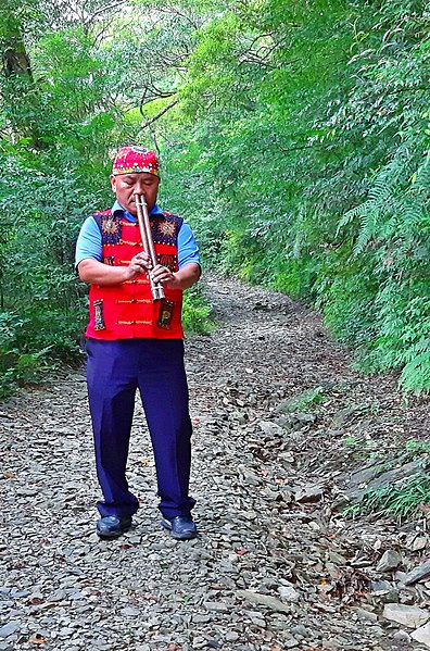
中文(繁體):浸水營古道起點為屏東縣枋寮水底寮,途經玉泉村、崁頭營、歸化門越過中央山脈後終點在臺東縣大武,全長約47公里,步道徒步路段長15.9公里,是台灣歷史上使用年代最悠久、最具代表性的歷史步道,數百年來,排灣族、卑南族、平埔族、漢人、荷蘭人、日本人等均使用這條聯繫東西兩岸往來最便捷的越嶺道,從事狩獵交易、民族遷徙、軍事征戰等活動。
在古道上聆聽由排灣族「拉瓦告」大頭目吹奏的排灣族口鼻笛,如泣如訴的笛音,更令人引發思古之幽情。 目前浸水營古道定位為國家步道,現況保存完整,沿線有多處史蹟點,極具文化內涵與時代意義。 |
| Date | |
| Source | Own work |
| Author | WEI, WAN-CHEN(魏琬臻) |
Licensing[edit]
I, the copyright holder of this work, hereby publish it under the following license:
This file is licensed under the Creative Commons Attribution-Share Alike 4.0 International license.
- You are free:
- to share – to copy, distribute and transmit the work
- to remix – to adapt the work
- Under the following conditions:
- attribution – You must give appropriate credit, provide a link to the license, and indicate if changes were made. You may do so in any reasonable manner, but not in any way that suggests the licensor endorses you or your use.
- share alike – If you remix, transform, or build upon the material, you must distribute your contributions under the same or compatible license as the original.

|
This image was uploaded as part of Wiki Loves Monuments 2020.
|
 |
File history
Click on a date/time to view the file as it appeared at that time.
| Date/Time | Thumbnail | Dimensions | User | Comment | |
|---|---|---|---|---|---|
| current | 04:03, 12 September 2020 | | 3,184 × 4,820 (9.46 MB) | WEI, WAN-CHEN (talk | contribs) | Uploaded own work with UploadWizard |
You cannot overwrite this file.
File usage on Commons
There are no pages that use this file.
-1(Photographs_by_WEI,_WAN-CHEN).jpg&oldid=665307041)