File:桃花台センター停留所の地図.gif
From Wikimedia Commons, the free media repository
Jump to navigation
Jump to search
桃花台センター停留所の地図.gif (500 × 500 pixels, file size: 18 KB, MIME type: image/gif)
File information
Structured data
Captions
Captions
Add a one-line explanation of what this file represents
Summary[edit]
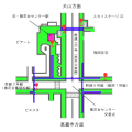
投稿者がja:2007年ja:5月8日に作成(最新版は2007年12月11日)した、ja:愛知県ja:小牧市にある「桃花台センター」と名の付く停留所の位置を示したja:地図。ja:緑色の部分はja:歩道、ja:青い部分は歩道橋を表している。 また画像の中で上から下へと伸びるja:道路は県道195号荒井大草線、左右に伸びる幹線道路は、桃花台センターja:交差点を基準に左側が桃花台鳥居松線(ja:幹線3号線)、右側が篠岡一丁目1号線(幹線6号線)である。
Licensing[edit]
| Public domainPublic domainfalsefalse |
| I, the copyright holder of this work, release this work into the public domain. This applies worldwide. In some countries this may not be legally possible; if so: I grant anyone the right to use this work for any purpose, without any conditions, unless such conditions are required by law. |
File history
Click on a date/time to view the file as it appeared at that time.
| Date/Time | Thumbnail | Dimensions | User | Comment | |
|---|---|---|---|---|---|
| current | 22:13, 10 December 2007 |  | 500 × 500 (18 KB) | 満月 (talk | contribs) | 投稿者が2007年12月11日に作成。桃花台センター停留所の各停留所の位置を示した地図。緑色の部分は歩道、青い部分は[[横断歩道� |
| 05:41, 8 May 2007 |  | 500 × 500 (17 KB) | 満月 (talk | contribs) | 道路名を修正 | |
| 10:16, 22 April 2007 |  | 500 × 500 (18 KB) | 満月 (talk | contribs) | 投稿者が2007年3月9日に作成(同年4月22日に一部修正)。桃花台センター停留所の各停留所の位置を示した地図。緑色の部分は[[歩道] | |
| 01:20, 9 March 2007 |  | 500 × 500 (18 KB) | 満月 (talk | contribs) | 投稿者が2007年3月9日に作成。桃花台センター停留所の各停留所の位置を示した地図。 ==ライセンス== {{GFDL}} Category:桃花台ニュータウンの画像 |
You cannot overwrite this file.
File usage on Commons
There are no pages that use this file.
File usage on other wikis
The following other wikis use this file:
- Usage on ja.wikipedia.org
