File:삼척 죽서루와 오십천- 강원도청.jpg
From Wikimedia Commons, the free media repository
Jump to navigation
Jump to search
Size of this preview: 800 × 533 pixels. Other resolutions: 320 × 213 pixels | 640 × 427 pixels | 1,024 × 683 pixels | 1,200 × 800 pixels.
Original file (1,200 × 800 pixels, file size: 777 KB, MIME type: image/jpeg)
File information
Structured data
Captions
Summary
[edit]Description삼척 죽서루와 오십천- 강원도청.jpg |
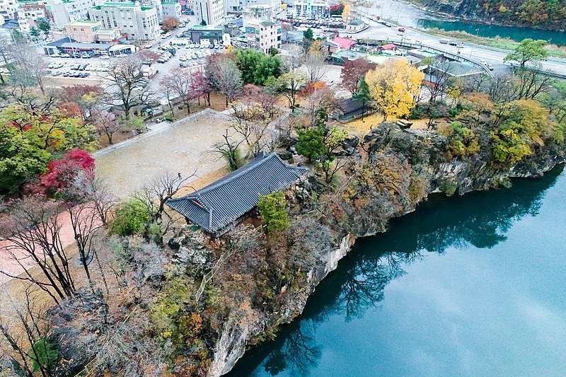
한국어: 삼척 죽서루(三陟 竹西樓)는 강원도 삼척시에 위치한 누각으로, 관동팔경 중의 하나이다. 다른 관동팔경의 누, 정이 바다를 끼고 있는 것과는 달리 죽서루만이 유일하게 강을 끼고 있다. |
Date | |
Source | https://www.kogl.or.kr/recommend/recommendDivView.do?recommendIdx=8236&division=img |
Author | 강원도청 |
Camera location | 37° 26′ 27.52″ N, 129° 09′ 35.82″ E | View this and other nearby images on: OpenStreetMap | 37.440977; 129.159949 |
---|
Licensing
[edit]This file is licensed under the Korea Open Government License Type I: Attribution.
| |
http://www.kogl.or.kr/open/info/license_info/by.doKOGL Type 1공공누리 제1유형 출처 표시truetrue |
File history
Click on a date/time to view the file as it appeared at that time.
Date/Time | Thumbnail | Dimensions | User | Comment | |
---|---|---|---|---|---|
current | 13:48, 5 June 2020 | 1,200 × 800 (777 KB) | Bongsun (talk | contribs) | Uploaded a work by 강원도청 from 공공누리 https://www.kogl.or.kr with UploadWizard |
You cannot overwrite this file.
File usage on Commons
There are no pages that use this file.
File usage on other wikis
The following other wikis use this file:
- Usage on ko.wikipedia.org
- Usage on ru.wikipedia.org
Metadata
This file contains additional information such as Exif metadata which may have been added by the digital camera, scanner, or software program used to create or digitize it. If the file has been modified from its original state, some details such as the timestamp may not fully reflect those of the original file. The timestamp is only as accurate as the clock in the camera, and it may be completely wrong.
Image title |
|
---|---|
Camera manufacturer | DJI |
Camera model | FC6310 |
Exposure time | 1/120 sec (0.0083333333333333) |
F-number | f/6.3 |
ISO speed rating | 3,200 |
Date and time of data generation | 16:31, 14 November 2018 |
Lens focal length | 8.8 mm |
Latitude | 37° 26′ 27.52″ N |
Longitude | 129° 9′ 35.82″ E |
Altitude | 42.55 meters below sea level |
Orientation | Normal |
Horizontal resolution | 240 dpi |
Vertical resolution | 240 dpi |
Software used | ACDSee Ultimate 2019 |
File change date and time | 19:51, 26 December 2018 |
Y and C positioning | Centered |
Exposure Program | Aperture priority |
Exif version | 2.3 |
Date and time of digitizing | 16:31, 14 November 2018 |
APEX shutter speed | 6.906891 |
APEX aperture | 5.310704 |
APEX exposure bias | 0 |
Maximum land aperture | 2.97 APEX (f/2.8) |
Subject distance | 0 meters |
Metering mode | Center weighted average |
Light source | Unknown |
Flash | Flash did not fire, No flash function |
DateTime subseconds | 902 |
File source | Digital still camera |
Scene type | A directly photographed image |
Custom image processing | Normal process |
Exposure mode | Auto exposure |
White balance | Auto white balance |
Focal length in 35 mm film | 24 mm |
Scene capture type | Standard |
Scene control | None |
Contrast | Hard |
Saturation | Normal |
Sharpness | Hard |
Subject distance range | Unknown |
GPS tag version | 0.0.3.2 |
Width | 5,472 px |
Height | 3,648 px |
Image width | 5,472 px |
Image height | 3,648 px |
Serial number of camera | 56b6ed679af686c7c15e79002d618d78 |