File:(An accurate map of North and South Carolina, with their Indian frontier, shewing in a distinct manner all the mounta)ins, rivers, swamps, marshes, bays, creeks, harbours, sandbanks and soundings on LOC gm71002153.jpg
Zur Navigation springen
Zur Suche springen

Größe dieser Vorschau: 800 × 574 Pixel. Weitere Auflösungen: 320 × 230 Pixel | 640 × 459 Pixel | 1.024 × 735 Pixel | 1.280 × 918 Pixel | 2.560 × 1.836 Pixel | 16.912 × 12.132 Pixel.
Originaldatei (16.912 × 12.132 Pixel, Dateigröße: 28,64 MB, MIME-Typ: image/jpeg)
Bildtexte
Kurzbeschreibungen
Ergänze eine einzeilige Erklärung, was diese Datei darstellt.
Beschreibung[Bearbeiten]
| Warnung | Diese Originaldatei ist sehr hochauflösend. Es könnte sein, dass diese Datei nicht richtig geladen werden kann oder dass der Browser einfriert, wenn die Datei in voller Größe geöffnet wird. Um diese Probleme zu vermeiden, kann der interaktive Bildbetrachter (ZoomViewer) verwendet werden. |
|---|
| Beschreibung |
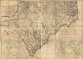
English: Scale ca. 1:530,000. Hand colored. Imperfect: Part of title wanting. Prime meridian: London. Relief shown by hachures. Depths shown by soundings. Shows precinct boundaries. Insets: The harbour of Port Royal [ca. 1:200,000]--The bar and harbour of Charlestown [ca. 1:75,000] LC Maps of North America, 1750-1789, 1394 Available also through the Library of Congress Web site as a raster image. Vault AACR2 |
||
| Title | [An accurate map of North and South Carolina, with their Indian frontier, shewing in a distinct manner all the mounta]ins, rivers, swamps, marshes, bays, creeks, harbours, sandbanks and soundings on the coasts; with the roads and Indian paths; as well as the boundary or provincial lines, the several townships, and other divisions of the land in both the provinces; | ||
| Shelf ID | G3900 1775 .M6 | ||
| Datum | |||
| Quelle | https://www.loc.gov/item/gm71002153/ | ||
| Urheber | Mouzon, Henry; Robert Sayer And John Bennett (Firm) | ||
| Genehmigung (Weiternutzung dieser Datei) |
|
||
| Andere Versionen |
|
||
| Location | South Carolina · Port Royal Sound · Charleston Harbor · United States · North Carolina | ||
| Part of | France In America · Rochambeau Map Collection · Military Battles And Campaigns · Catalog · American Memory · Geography And Map Division · American Revolution And Its Era: Maps And Charts Of North America And The West Indies, 1750-1789 | ||
| Subject | Port Royal Sound (S.C.) · Charleston Harbor · North Carolina · United States · Maps · Early Works To 1800 · Charleston Harbor (S.C.) · Administrative And Political Divisions · South Carolina · Port Royal Sound |

ins,_rivers,_swamps,_marshes,_bays,_creeks,_harbours,_sandbanks_and_soundings_on_LOC_gm71002153.jpg&action=edit§ion=1)
Lizenz[Bearbeiten]
ins,_rivers,_swamps,_marshes,_bays,_creeks,_harbours,_sandbanks_and_soundings_on_LOC_gm71002153.jpg&action=edit§ion=2)
|
Dies ist eine originalgetreue fotografische Reproduktion eines zweidimensionalen Kunstwerks. Das Kunstwerk an sich ist aus dem folgenden Grund gemeinfrei:
Nach offizieller Ansicht der Wikimedia Foundation sind originalgetreue Reproduktionen zweidimensionaler gemeinfreier Werke gemeinfrei. Diese fotografische Reproduktion wird daher auch als gemeinfrei in den Vereinigten Staaten angesehen. Die Verwendung dieser Werke kann in anderen Rechtssystemen verboten oder nur eingeschränkt erlaubt sein. Zu Details siehe Reuse of PD-Art photographs.
| ||||
Dateiversionen
Klicke auf einen Zeitpunkt, um diese Version zu laden.
| Version vom | Vorschaubild | Maße | Benutzer | Kommentar | |
|---|---|---|---|---|---|
| aktuell | 23:14, 4. Jun. 2018 | | 16.912 × 12.132 (28,64 MB) | Fæ (Diskussion | Beiträge) | LOC Maps https://www.loc.gov/item/gm71002153/ #20152 |
Du kannst diese Datei nicht überschreiben.
Dateiverwendung
Die folgende Seite verwendet diese Datei:
ins,_rivers,_swamps,_marshes,_bays,_creeks,_harbours,_sandbanks_and_soundings_on_LOC_gm71002153.jpg&oldid=733914561)