File:0010522 Narmada Mandir Complex, Amarkantak 078.jpg

Original file (4,624 × 3,468 pixels, file size: 6.49 MB, MIME type: image/jpeg)
Captions
Captions
Summary
[edit]
| Description |
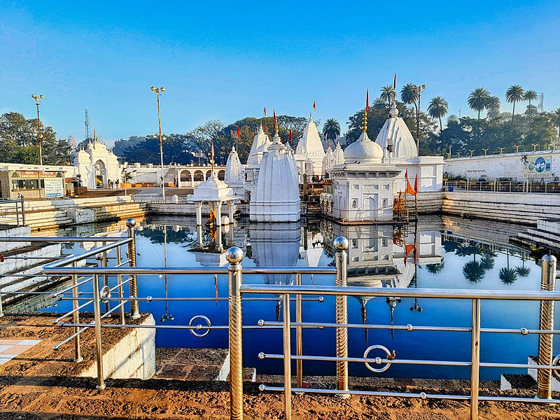
English: The Narmada mandir complex is a collection of temples from all major Hindu traditions, in different styles to revere the start of Narmada river. It is the primary pilgrimage destination for Hindus visiting Amarkantak as a religious destination. It is also referred to as Narmada udgam temple.
The site finds mention in the Hindu Puranas. It is believed to be the place where rishis and saints of Hinduism meditated. These include Brighu, Maikal, Vyas, Kabir and others. The documented history, however, is unavailable. It is unclear when the oldest temple in this complex was built. From the style and artwork, the oldest temple here is from the 11th century. This site likely saw temples being rebuilt and expanded by many dynasties. Minor inscriptions attest to dedications by kings and queens of the Kalachuris, Bhagels, Bhonsle, Maharani Ahilya Devi and others. Wealthy pilgrims from south Madhya Pradesh, Maharashtra and Gujarat have also gifted structures and services. The beheaded statues of Lakhan and Uddal here mark the damaged caused to this site and region during the Aurangzeb period. The temples complex has a torana (gateway) for entrance. Inside, all temples are painted in white and they surround the pool of water that marks the start of Narmada river's journey to western peninsular coast of India. The site has historic as well as modern era temples. The site also preserves many ruins, the beheaded stone statues, bronze statues such as of Nataraja in Tamil Nadu style, Surya with his chariot in Rajasthan style, and others – all of these are spots for the devout to offer prayers. |
| Date | |
| Source | Own work |
| Author | Ms Sarah Welch |
| Camera location | | View this and other nearby images on: OpenStreetMap |
|---|
Licensing
[edit]
| This file is made available under the Creative Commons CC0 1.0 Universal Public Domain Dedication. | |
| The person who associated a work with this deed has dedicated the work to the public domain by waiving all of their rights to the work worldwide under copyright law, including all related and neighboring rights, to the extent allowed by law. You can copy, modify, distribute and perform the work, even for commercial purposes, all without asking permission.
|
File history
Click on a date/time to view the file as it appeared at that time.
| Date/Time | Thumbnail | Dimensions | User | Comment | |
|---|---|---|---|---|---|
| current | 23:24, 1 December 2022 | | 4,624 × 3,468 (6.49 MB) | Ms Sarah Welch (talk | contribs) | Uploaded own work with UploadWizard |
You cannot overwrite this file.
File usage on Commons
The following page uses this file:
File usage on other wikis
The following other wikis use this file:
- Usage on en.wikipedia.org
- Usage on www.wikidata.org