File:1. Plan de la Battaille de Fridberg (sic) ou l'on voit l'Ordre de Bataille (...) (Map of the battle of Friedberg which shows the campaign order) (BM 1838,1215.365).jpg

Original file (1,878 × 1,798 pixels, file size: 276 KB, MIME type: image/jpeg)
Captions
Captions
Summary
[edit]_ou_l%27on_voit_l%27Ordre_de_Bataille_(...)_(Map_of_the_battle_of_Friedberg_which_shows_the_campaign_order)_(BM_1838,1215.365).jpg&action=edit§ion=1)
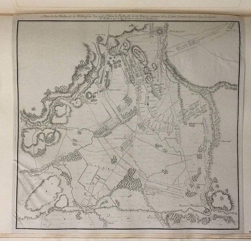
| 1. Plan de la Battaille de Fridberg (sic) ou l'on voit l'Ordre de Bataille (...) (Map of the battle of Friedberg which shows the campaign order)
( |
||||||||||||||||||||||||
|---|---|---|---|---|---|---|---|---|---|---|---|---|---|---|---|---|---|---|---|---|---|---|---|---|
| Title |
1. Plan de la Battaille de Fridberg (sic) ou l'on voit l'Ordre de Bataille (...) (Map of the battle of Friedberg which shows the campaign order) |
|||||||||||||||||||||||
| Description |
English: Schematic plan of the area around Friedberg showing the location of French and Austrian troops; first of a series of three maps. after 1796
Etching |
|||||||||||||||||||||||
| Date | 1796 (after) | |||||||||||||||||||||||
| Medium | paper | |||||||||||||||||||||||
| Dimensions |
|
|||||||||||||||||||||||
| Collection |
|
|||||||||||||||||||||||
| Current location |
Prints and Drawings |
|||||||||||||||||||||||
| Accession number |
1838,1215.365 |
|||||||||||||||||||||||
| Notes | The battle of Friedberg occured in 1796. As Schmidt died in 1775 it is impossible that he made this map. It was acquired with a large collection of prints by Schmidt, which explains why it is kept in the Schmidt series (album IV) | |||||||||||||||||||||||
| Source/Photographer | https://www.britishmuseum.org/collection/object/P_1838-1215-365 | |||||||||||||||||||||||
| Permission (Reusing this file) |
© The Trustees of the British Museum, released as CC BY-NC-SA 4.0 | |||||||||||||||||||||||
Licensing
[edit]_ou_l%27on_voit_l%27Ordre_de_Bataille_(...)_(Map_of_the_battle_of_Friedberg_which_shows_the_campaign_order)_(BM_1838,1215.365).jpg&action=edit§ion=2)
This image is in the public domain because it is a mere mechanical scan or photocopy of a public domain original, or – from the available evidence – is so similar to such a scan or photocopy that no copyright protection can be expected to arise. The original itself is in the public domain for the following reason:
This tag is designed for use where there may be a need to assert that any enhancements (eg brightness, contrast, colour-matching, sharpening) are in themselves insufficiently creative to generate a new copyright. It can be used where it is unknown whether any enhancements have been made, as well as when the enhancements are clear but insufficient. For known raw unenhanced scans you can use an appropriate {{PD-old}} tag instead. For usage, see Commons:When to use the PD-scan tag.  | ||||
File history
Click on a date/time to view the file as it appeared at that time.
| Date/Time | Thumbnail | Dimensions | User | Comment | |
|---|---|---|---|---|---|
| current | 11:30, 16 May 2020 | | 1,878 × 1,798 (276 KB) | Copyfraud (talk | contribs) | British Museum public domain uploads (Copyfraud/BM) Maps in the British Museum 1796 #525/703 |
You cannot overwrite this file.
File usage on Commons
The following page uses this file:
_ou_l%27on_voit_l%27Ordre_de_Bataille_(...)_(Map_of_the_battle_of_Friedberg_which_shows_the_campaign_order)_(BM_1838,1215.365).jpg)
_ou_l%27on_voit_l%27Ordre_de_Bataille_(...)_(Map_of_the_battle_of_Friedberg_which_shows_the_campaign_order)_(BM_1838,1215.365).jpg&oldid=848715158)