File:100 BCE – 300 CE Viratrajgadde, Erradibba Buddhist Stupa Khammam, Telangana India - 12.jpg

Original file (4,032 × 3,024 pixels, file size: 7.47 MB, MIME type: image/jpeg)
Captions
Captions
Summary
[edit]
| Description |
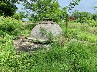
English: This site is located near a remote village name Nelakondapalli, between Vijayawada (Andhra Pradesh) and Hyderabad (Telangana). The closest town near this site is Khammam. The site can be reached with state highway 365A, that connects Khammam to the modern highway 65.
The site became of interest in the 1960s when inscription stones were discovered and reported by local farmers in the area. It was excavated in stages between 1970 and 1990. This effort brought to light a 170 foot diameter Mahastupa, then a monastic complex nearby. Additionally a votive Stupa was found. A bronze Avalokitesvara, several statues of the Buddha and other significant discoveries here were moved to the state museum. The excavation effort also yielded pottery, stone jewelry and coins traced to the Ikshvaku and Vishnukundini periods. The site is likely from 100 BCE to 300 CE, with continuous major settlement through about the 14th century. Then the region went into decline, and is now a minor remote village. The Stupa is a series of concentric circular walls of brick with radiating spokes. The central hub 36 feet in diameter, while the outer edge of the stupa measures 170 feet. It has a vedica, a lower pradakshina-patha, and ayaka platforms with a dome. The excavated height is 46 feet. The foundation of the Vihara complex suggests that there were about hundred cells here with an entrance on the eastern side. There is a village park and walkways at this site and nearby. A significant man made lake is close by, with Hindu villages and farms for miles in every direction near this site. It is well preserved. |
| Date | |
| Source | Own work |
| Author | Ms Sarah Welch |
| Camera location | | View this and other nearby images on: OpenStreetMap |
|---|
Licensing
[edit]
| This file is made available under the Creative Commons CC0 1.0 Universal Public Domain Dedication. | |
| The person who associated a work with this deed has dedicated the work to the public domain by waiving all of their rights to the work worldwide under copyright law, including all related and neighboring rights, to the extent allowed by law. You can copy, modify, distribute and perform the work, even for commercial purposes, all without asking permission.
|
File history
Click on a date/time to view the file as it appeared at that time.
| Date/Time | Thumbnail | Dimensions | User | Comment | |
|---|---|---|---|---|---|
| current | 15:40, 14 February 2021 | | 4,032 × 3,024 (7.47 MB) | Ms Sarah Welch (talk | contribs) | Uploaded own work with UploadWizard |
You cannot overwrite this file.
File usage on Commons
There are no pages that use this file.
File usage on other wikis
The following other wikis use this file:
- Usage on en.wikipedia.org