File:11-09-fotofluege-cux-allg-25a.jpg
跳至導覽
跳至搜尋

預覽大小:600 × 600 像素。 其他解析度:240 × 240 像素 | 480 × 480 像素 | 768 × 768 像素 | 1,024 × 1,024 像素 | 2,048 × 2,048 像素 | 2,848 × 2,848 像素。
原始檔案 (2,848 × 2,848 像素,檔案大小:5.53 MB,MIME 類型:image/jpeg)
說明
說明
添加單行說明來描述出檔案所代表的內容
摘要
[編輯]| 描述 |
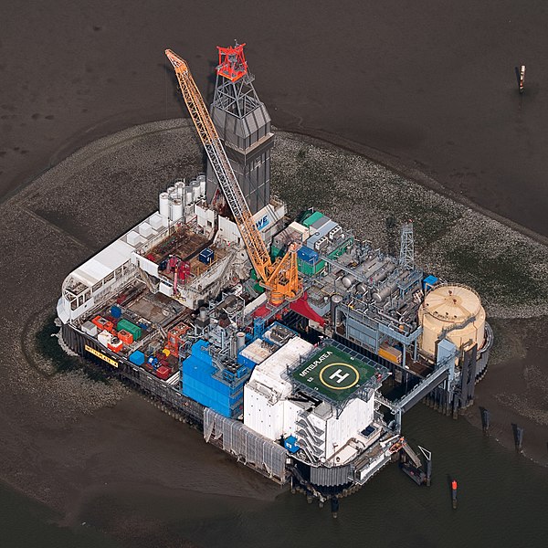
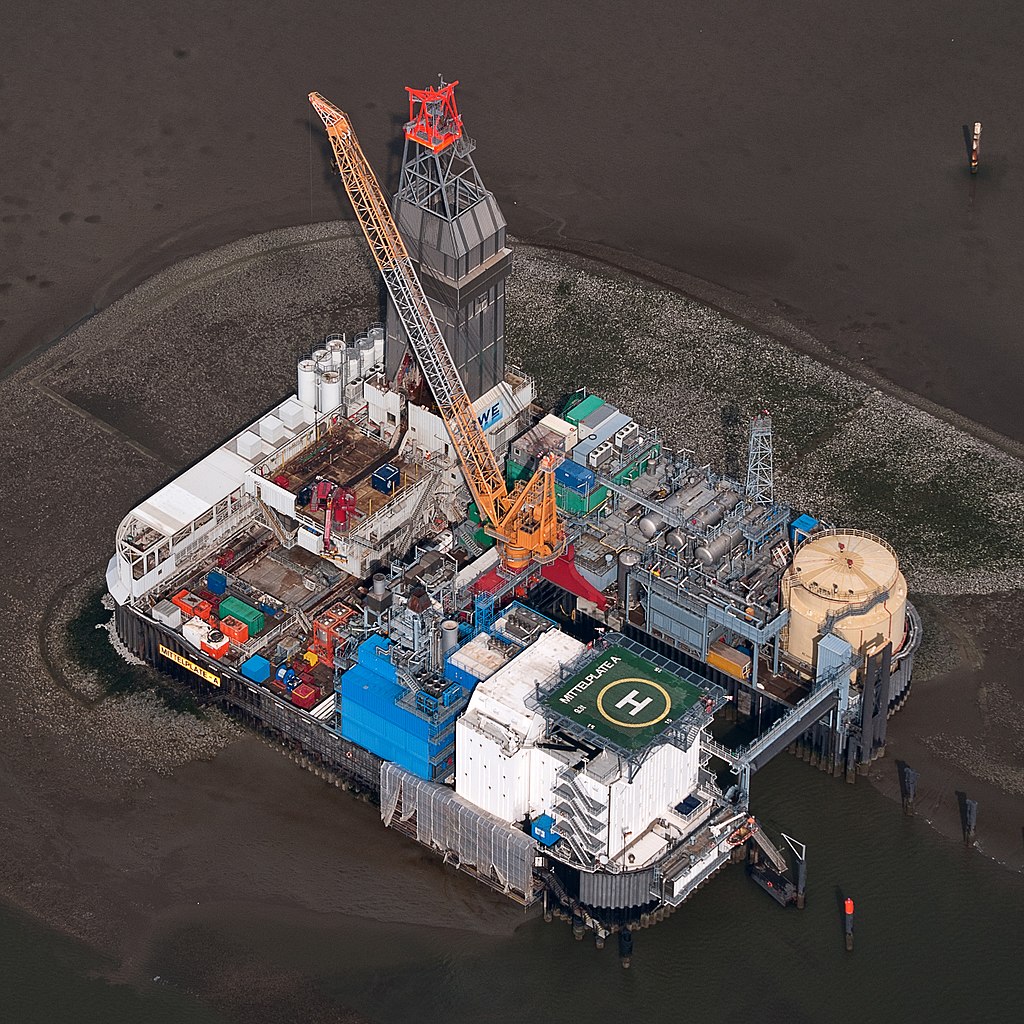
Deutsch: Fotoflug Nordsee; Ölbohrinsel im Ölfeld Mittelplate
English: Germany’s largest oil field Mittelplate
Español: Vista aérea de la plataforma petrolera de Mittelplate, el mayor yacimiento petrolífero de Alemania.
Français : Vue aérienne de Mittelplate, le plus grand champ pétrolifère d'Allemagne
Polski: Platforma wiertnicza na największym niemieckim polu naftowym „Mittelplate” znajdującym się na Morzu Północnym.
Português: Vista aérea da plataforma petrolífera de Mittelplate, o maior campo de petróleo da Alemanha. |
|||||||||||||||||||||||
| 日期 | ||||||||||||||||||||||||
| 來源 | 自己的作品 | |||||||||||||||||||||||
| 作者 |
|
|||||||||||||||||||||||
| 授權許可 (重用此檔案) |
|
|||||||||||||||||||||||
| 其他版本 |
 |
|||||||||||||||||||||||

| 拍攝地點 | | 位於此地的本圖片與其他圖片: OpenStreetMap |
|---|
評價
[編輯]
|
This image was selected as picture of the day on Wikimedia Commons for 2 February 2016. It was captioned as follows: English: Germany’s largest oil field Mittelplate Other languages:
Bosanski: Najveće naftno polje u Njemačkoj, Mittelplate Català: Mittelplate, el camp petrolier més gran d'Alemanya. Deutsch: Fotoflug Nordsee; Ölbohrinsel im Ölfeld Mittelplate English: Germany’s largest oil field Mittelplate Español: Vista aérea de la plataforma petrolera de Mittelplate, el mayor yacimiento petrolífero de Alemania. Italiano: Vista aerea della piattaforma petrolifera di Mittelplate, il principale giacimento petrolifero tedesco. Português: Vista aérea da plataforma petrolífera de Mittelplate, o maior campo de petróleo da Alemanha. Suomi: Mittelplate, suurin öljykentän Saksan. Македонски: Мителплате — најголемото нафтено поле во Германија. Русский: Миттельплате, крупнейшее месторождение нефти Германии. 한국어: 독일에서 가장 큰 유전 미텔플라테. 中文: 德国最大油井 Mittelplate 中文(繁體): 德國最大油井 Mittelplate |
授權條款
[編輯]
| Dieses Foto entstand aufgrund eines Projektes, das von Wikimedia Deutschland e. V. gefördert wurde.
Im Rahmen des „Community-Projektbudgets“ sollen Luftbilder u.a. von Inseln, Halligen, Sanden und Küstenorten der deutschen Nordseeküste angefertigt werden. Das Projekt „Fotoflüge“ wurde im September 2011 begonnen. |
此檔案採用創用CC 姓名標示-相同方式分享 3.0 德國授權條款。
- 您可以自由:
- 分享 – 複製、發佈和傳播本作品
- 重新修改 – 創作演繹作品
- 惟需遵照下列條件:
- 姓名標示 – 您必須指名出正確的製作者,和提供授權條款的連結,以及表示是否有對內容上做出變更。您可以用任何合理的方式來行動,但不得以任何方式表明授權條款是對您許可或是由您所使用。
- 相同方式分享 – 如果您利用本素材進行再混合、轉換或創作,您必須基於如同原先的相同或兼容的條款,來分布您的貢獻成品。

檔案歷史
點選日期/時間以檢視該時間的檔案版本。
| 日期/時間 | 縮圖 | 尺寸 | 用戶 | 備註 | |
|---|---|---|---|---|---|
| 目前 | 2015年1月13日 (二) 20:40 | | 2,848 × 2,848(5.53 MB) | Ralf Roletschek(對話 | 貢獻) | volle Auflösung aus Original |
| 2013年2月28日 (四) 17:13 |  | 2,848 × 2,848(3.94 MB) | Jkadavoor(對話 | 貢獻) | Reverted to version as of 21:23, 4 September 2011 per Commons:Overwriting_existing_files#DO_NOT_overwrite : Files that have been awarded a special status like Commons Featured Picture, or similar status on another Wikimedia project. Such files are ... | |
| 2013年2月21日 (四) 15:32 |  | 5,932 × 5,932(14.62 MB) | Ralf Roletschek(對話 | 貢獻) | größere Version | |
| 2011年9月4日 (日) 21:23 |  | 2,848 × 2,848(3.94 MB) | Ralf Roletschek(對話 | 貢獻) | {{Information |Description=Fotoflug Nordsee |Source={{own}} |Date=2011-09-04 |Author=Ralf Roletschek (<span class="signature-talk">talk</span>) |Permission= |other_versions=[[File:11-09-fotofluege-cux |
無法覆蓋此檔案。
檔案用途
下列42個頁面有用到此檔案:
- Drilling rig
- Oil platform
- User:Ralf Roletschek/gallery/2011-Fotoflug1
- Commons:Featured picture candidates/File:11-09-fotofluege-cux-allg-25a.jpg
- Commons:Featured picture candidates/Log/June 2012
- Commons:Featured picture candidates/Log/March 2013
- Commons:Featured picture candidates/removal/File:11-09-fotofluege-cux-allg-25a.jpg
- Commons:Featured pictures/Places/Industry
- Commons:Featured pictures/chronological/2012-A
- Commons:Picture of the Year/2012/Galleries/2012-A
- Commons:Picture of the Year/2012/Galleries/ALL
- Commons:Picture of the Year/2012/Galleries/Constructions and buildings
- Commons:Picture of the Year/2012/Galleries/Index/10
- Commons:Picture of the Year/2012/Galleries/JUN
- Commons:Picture of the Year/2012/R1/11-09-fotofluege-cux-allg-25a.jpg
- Commons:Picture of the Year/2012/Results/R1/ALL
- Commons:Picture of the Year/2012/Results/R1/ALL/gallery
- Commons:Picture of the Year/2012/Results/R1/ALL/thumbnailtable
- Commons:Picture of the Year/2012/Results/R1/Constructions and buildings
- Commons:Picture of the Year/2013/R1/Test page
- Commons:Quality images/Subject/Places/Man made structures/Buildings, Exterior/Part 2
- Commons:Quality images candidates/Archives September 2011
- Commons:Village pump/Archive/2013/07
- Commons talk:Quality images/Subject/Places/Man made structures
- File:11-09-fotofluege-cux-allg-25.jpg
- Template:Potd/2016-02
- Template:Potd/2016-02-02
- Template:Potd/2016-02-02 (bs)
- Template:Potd/2016-02-02 (cs)
- Template:Potd/2016-02-02 (de)
- Template:Potd/2016-02-02 (en)
- Template:Potd/2016-02-02 (es)
- Template:Potd/2016-02-02 (hu)
- Template:Potd/2016-02-02 (it)
- Template:Potd/2016-02-02 (ko)
- Template:Potd/2016-02-02 (mk)
- Template:Potd/2016-02-02 (nl)
- Template:Potd/2016-02-02 (pt)
- Template:Potd/2016-02-02 (zh-hans)
- Template:Potd/2016-02-02 (zh-hant)
- Category:Mittelplate
- Category:Petroleum engineering
全域檔案使用狀況
以下其他 wiki 使用了這個檔案:
- ar.wikipedia.org 的使用狀況
- ar.wikinews.org 的使用狀況
- be-tarask.wikipedia.org 的使用狀況
- bg.wikipedia.org 的使用狀況
- ca.wikipedia.org 的使用狀況
- ceb.wikipedia.org 的使用狀況
- crh.wikipedia.org 的使用狀況
- cs.wikipedia.org 的使用狀況
- cv.wikipedia.org 的使用狀況
- da.wikipedia.org 的使用狀況
- de.wikipedia.org 的使用狀況
- Wattenmeer (Nordsee)
- Erdöl
- Luftbildfotografie
- Bohrinsel
- Erdölförderung in Deutschland
- Mittelplate (Ölfeld)
- Friedrichskoog
- Nordseeöl
- Recht am Bild der eigenen Sache
- Wikipedia:Projekt Fotoflüge/2011/September
- Wikipedia:Projekt Fotoflüge/Ergebnisse
- Wikipedia Diskussion:Projekt Fotoflugkurs Cuxhaven 2013
- Wikipedia:AdminConvention 2016/Teilnehmer
- Benutzer:Artikelstube/Liste von Bauverfahren
- de.wikiversity.org 的使用狀況
- de.wikivoyage.org 的使用狀況
- el.wikipedia.org 的使用狀況
- en.wikipedia.org 的使用狀況
- Oil platform
- North Sea oil
- Wikipedia:WikiProject Energy
- Mittelplate
- Wikipedia:Featured pictures/Places/Architecture
- Marine architecture
- User talk:Ralf Roletschek
- User talk:Nikhil B
- Wikipedia:WikiProject Energy/Recognized content
- Portal:Energy/Explore/Recognized content
- Accommodation platform
- Wikipedia:Featured pictures thumbs/59
- Wikipedia:Featured picture candidates/November-2016
- Wikipedia:Featured picture candidates/Mittelplate
- Wikipedia:Wikipedia Signpost/2016-11-26/Featured content
- Wikipedia:Wikipedia Signpost/Single/2016-11-26
檢視此檔案的更多全域使用狀況。