File:12nm hypothetical Territorial Sea compared with Northern Limit Line, North Korea.jpg

Исходный файл (1315 × 938 пкс, размер файла: 147 КБ, MIME-тип: image/jpeg)
Краткие подписи
Краткие подписи
Краткое описание
[править]
| Описание |
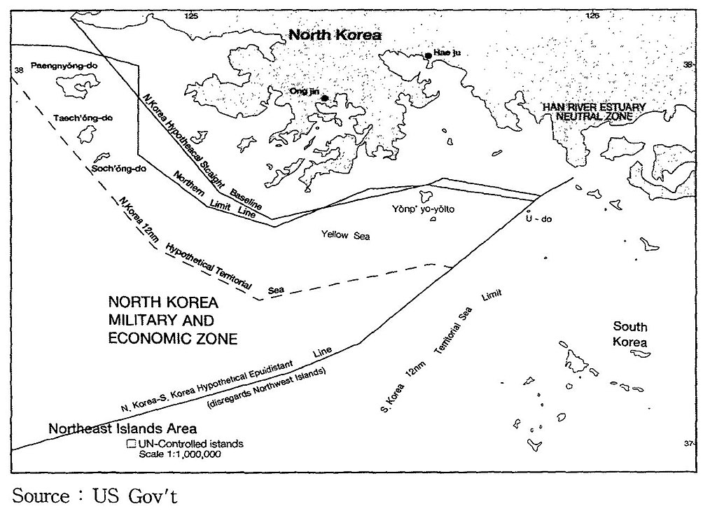
English: A US Government map showing where a North Korean 12 nautical mile Territorial Waters limit would be, when disregarding the north west UN Command islands, compared to the UN Command created Northern Limit Line. |
| Дата | Неизвестная дата |
| Источник | http://118.129.184.33/pub/docu/kr/AM/06/AM062001B01/IMAGE/AM06-2001-B01-0210-01.jpg |
| Автор | US Government |
| Другие версии |
Производные работы от этого файла: Yeonpyeong Island live firing range map.png:  |
Map taken from HTML version of the paper, which included this US Government credited map:
Seong-Geol Hong, Sun-Pyo Kim, Hyung-Ki Lee (2001-06-30). "Fisheries Cooperation and Maritime Delimitation Issues between North Korea and Its Neighboring Countries". Ocean Policy Research 16 (1): 191-216. Korea Maritime Institute. Archived from the original on 2011-07-23. Retrieved on 2010-11-28.
HTML version of paper: http://118.129.184.33/pub/docu/kr/AM/06/AM062001B01/AM06-2001-B01-006.HTM[недоступная ссылка]
According to a Korean Central News Agency article "Northern Limit Line rejected" of 2 August 2002[1] archive copy at the Wayback Machine "the U.S. government distributed [this map] to the participants in the UN conference on maritime law held in the U.S. in 1980". The map is also published in paper by Kim, Jung-Gun (Spring-Summer 1985). "Reflections on the attitude of North Korea toward the Law of the Sea (UNCLOS III Treaty)". Asian Perspective 9 (1)., and John Barry Kotch & Michael Abbey in Asian Perspective, Vol. 27, No. 2, 2003, pp. 175-204 archive copy at the Wayback Machine.
The CIA report "The West Coast Korean Islands", BGI RP 74-9, January 1974 (Declassified 2000-04-18 as CIA-RDP-84-00825R000300120001-7)[2] describes this, or a very similar, map. However the map itself is redacted from the declassified version of the report.
Лицензирование
[править]
Это произведение находится в общественном достоянии (англ. public domain) в Соединённых Штатах Америки, так как оно является работой, выполненной должностным лицом или наёмным сотрудником Федерального правительства США в качестве части служебных обязанностей этого лица. Правовой статус регламентируется в соответствии с разделом 17, главой 1, секцией 105 Кодекса Соединённых Штатов. См. Авторское право.
Обратите внимание: это относится только к оригинальным (первоначальным) произведениям Федерального правительства, а не к произведениям любого отдельного штата США, территории, содружества, округа, муниципалитета или любой другой территориальной единицы. Этот шаблон также не относится к дизайну почтовых марок, изданных Почтовой службой США с 1978 года. (См. § 313.6(C)(1) в Compendium of U.S. Copyright Office Practices). Это также не относится к определённым монетам США; см. Условия использования Монетного двора США.
|
 | |
| Этот файл был определён как свободный от известных ограничений авторского права, а также связанных и смежных прав. | ||
История файла
Нажмите на дату/время, чтобы увидеть версию файла от того времени.
| Дата/время | Миниатюра | Размеры | Участник | Примечание | |
|---|---|---|---|---|---|
| текущий | 23:05, 28 ноября 2010 | | 1315 × 938 (147 КБ) | Rwendland (обсуждение | вклад) | {{Information |Description={{en|1=A US Government map showing where a North Korean 12 nautical mile Territorial Waters limit would be, when disregarding the north west UN Command islands, compared to the UN Command created Northern Limit Line.}} |Source=h |
Вы не можете перезаписать этот файл.
Использование файла
Следующая страница использует этот файл:
Глобальное использование файла
Данный файл используется в следующих вики:
- Использование в en.wikipedia.org
- Использование в fr.wikipedia.org
- Использование в id.wikipedia.org
- Использование в ko.wikipedia.org
- Использование в no.wikipedia.org
- Использование в ru.wikipedia.org
- Использование в uk.wikipedia.org
- Использование в vi.wikipedia.org
- Использование в zh.wikipedia.org