File:14-20-22-fort-mont-bart.jpg
跳转到导航
跳转到搜索

本预览的尺寸:800 × 596像素。 其他分辨率:320 × 238像素 | 640 × 476像素 | 1,024 × 762像素 | 1,280 × 953像素 | 2,560 × 1,906像素 | 3,710 × 2,762像素。
原始文件 (3,710 × 2,762像素,文件大小:6.89 MB,MIME类型:image/jpeg)
说明
说明
添加一行文字以描述该文件所表现的内容
摘要
[编辑]| 描述 |
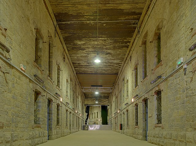
本文件使用Commonist. Dansk: Den gamle indre gård ved kasernerne ved Fort du Mont Bart, Frankrig. Under 1. verdenskrig var de dækket af jernbanespor, beton og jord.
English: Bart hill fortifications (HDR), Bavans, France.
Français : Dans l'ancienne cour intérieure du casernement, recouverte pendant la première guerre mondiale de rails de chemin de fer, de béton et de terre. |
||||||||||||||||||||||
| 日期 | |||||||||||||||||||||||
| 来源 | 自己的作品 | ||||||||||||||||||||||
| 作者 |
|
||||||||||||||||||||||

| 相机位置 | | 在以下服务上查看本图像和附近其他图像: OpenStreetMap |
|---|
|

本图像被选为2010年12月3日的今日图片。其说明如下: English: The old courtyard of the barracks, covered during the First World War with railroad rails, concrete and soil. Fort du Mont Bart, France. 其他语言:
Čeština: Starý dvůr kasáren pevnosti Fort du Mont Bart, překrytý za první světové války železničními kolejemi, betonem a zeminou Dansk: Den gamle indre gård ved kasernerne ved Fort du Mont Bart, Frankrig. Under 1. verdenskrig var de dækket af jernbanespor, beton og jord. Deutsch: Der alte Kasernenhof des Fort du Mont Bart in Frankreich. Im Ersten Weltkrieg war der Hof mit Eisenbahnschienen, Beton und Erde bedeckt. English: The old courtyard of the barracks, covered during the First World War with railroad rails, concrete and soil. Fort du Mont Bart, France. Español: El viejo patio de barracones, cubierto durante la Primera Guerra Mundial con raíles de tren, hormigón y tierra. Fort du Mont Bart, Francia. Français : Fort du Mont Bart : Dans l'ancienne cour intérieure du casernement, recouverte pendant la première guerre mondiale de rails de chemin de fer, de béton et de terre. Íslenska: Gamall hallargarður í Mont Bart virkinu, Frakklandi. Í fyrstu heimstyrjöldinni var garðurinn með lestarteina með malbiks undirlagi. Italiano: Il cortile del fort du Mont Bart (Francia), coperto durante la prima guerra mondiale dalle rotaie della ferrovia Magyar: A franciaországi Fort du Mont Bart belső udvara. Az első világháború alatt az udvart vasúti sínekkel, betonnal és talajjal fedték le. Nederlands: Binnenplaats van het Fort du Mont Bart, ten zuiden van de Oost-Franse stad Montbéliard, die tijdens de Eerste Wereldoorlog werd overkapt met een constructie van spoorrails, beton en grond. Македонски: Касарната на тврдината Мон Бар, Франција. Русский: Старый двор казарм, покрытых во время Первой мировой войны железными дорогами, бетоном и почвой. Крепость Мон-Бар, Франция. 日本語: モンバール要塞(フランス)の兵舎の中庭。第一次世界大戦中に、鉄道のレールとコンクリートと土によって覆いが作られた。 中文: 法国巴特杜蒙特堡古老的兵营院子,保留了第一次世界大战期间建设的铁路钢轨,混凝土和土壤。 |
许可协议
[编辑]
本文件采用知识共享署名 3.0 未本地化版本许可协议授权。
- 您可以自由地:
- 共享 – 复制、发行并传播本作品
- 修改 – 改编作品
- 惟须遵守下列条件:
- 署名 – 您必须对作品进行署名,提供授权条款的链接,并说明是否对原始内容进行了更改。您可以用任何合理的方式来署名,但不得以任何方式表明许可人认可您或您的使用。
文件历史
点击某个日期/时间查看对应时刻的文件。
| 日期/时间 | 缩略图 | 大小 | 用户 | 备注 | |
|---|---|---|---|---|---|
| 当前 | 2010年8月2日 (一) 08:21 | | 3,710 × 2,762(6.89 MB) | ComputerHotline(留言 | 贡献) |
您不可以覆盖此文件。
文件用途
以下48个页面使用本文件:
- User:ComputerHotline/Archive 1
- User:ComputerHotline/Archive 2
- User:ComputerHotline/examples (3)
- User:Thomas81/Potd
- Commons:Featured picture candidates/File:14-20-22-fort-mont-bart.jpg
- Commons:Featured picture candidates/Log/August 2010
- Commons:Featured pictures/Places/Interiors
- Commons:Featured pictures/chronological/2010-B
- Commons:Picture of the Year/2010/Galleries/Index/10
- Commons:Picture of the Year/2010/Galleries/Index/Interiors
- Commons:Picture of the Year/2010/Galleries/Interiors
- Commons:Picture of the Year/2010/Galleries/Interiors/Large
- Commons:Picture of the Year/2010/Galleries/Interiors/Small
- Commons:Picture of the Year/2010/Galleries/Table
- Commons:Picture of the Year/2010/Galleries/Table/08
- Commons:Picture of the Year/2010/R1/File:14-20-22-fort-mont-bart.jpg
- Commons:Picture of the Year/2010/Results/R1/ALL/Table
- Commons:Picture of the Year/2010/Results/R1/Interiors
- Commons:Picture of the Year/2010/Results/R1/Interiors/Table
- Commons:Potd/2010-12 (da)
- Commons:Potd/2010-12 (de)
- Commons:Potd/2010-12 (nl)
- Commons:Potd/2010-12 (pt)
- Commons:Quality images/Subject/Places/Man made structures/Buildings, Exterior/Part 1a
- Commons:Quality images candidates/Archives August 2010
- Commons talk:Picture of the Year/2010/Galleries/Table
- Commons talk:Quality images/Subject/Places/Man made structures
- Template:Potd/2010-12
- Template:Potd/2010-12-03
- Template:Potd/2010-12-03 (cs)
- Template:Potd/2010-12-03 (da)
- Template:Potd/2010-12-03 (de)
- Template:Potd/2010-12-03 (en)
- Template:Potd/2010-12-03 (es)
- Template:Potd/2010-12-03 (fr)
- Template:Potd/2010-12-03 (hu)
- Template:Potd/2010-12-03 (is)
- Template:Potd/2010-12-03 (it)
- Template:Potd/2010-12-03 (ja)
- Template:Potd/2010-12-03 (ko)
- Template:Potd/2010-12-03 (mk)
- Template:Potd/2010-12-03 (nl)
- Template:Potd/2010-12-03 (pam)
- Template:Potd/2010-12-03 (pt)
- Template:Potd/2010-12-03 (ru)
- Template:Potd/2010-12-03 (zh-hans)
- Template:Potd/2010-12 (zh-hans)
- Category:2010-08-01
全域文件用途
以下其他wiki使用此文件:
- ba.wikipedia.org上的用途
- be-tarask.wikipedia.org上的用途
- bn.wikipedia.org上的用途
- crh.wikipedia.org上的用途
- cv.wikipedia.org上的用途
- en.wikipedia.org上的用途
- fa.wikipedia.org上的用途
- fr.wikipedia.org上的用途
- ha.wikipedia.org上的用途
- hu.wikipedia.org上的用途
- it.wikipedia.org上的用途
- ko.wikipedia.org上的用途
- krc.wikipedia.org上的用途
- lbe.wikipedia.org上的用途
- mk.wikipedia.org上的用途
- os.wikipedia.org上的用途
- pl.wikipedia.org上的用途
- pt.wikipedia.org上的用途
- ru.wikipedia.org上的用途
- ru.wikinews.org上的用途
- sah.wikipedia.org上的用途
- sv.wikipedia.org上的用途
- vi.wikipedia.org上的用途
- www.wikidata.org上的用途
- xal.wikipedia.org上的用途
- zh.wikipedia.org上的用途