File:15-18-19-f-roppe-lp.jpg
跳转到导航
跳转到搜索

本预览的尺寸:758 × 599像素。 其他分辨率:304 × 240像素 | 607 × 480像素 | 972 × 768像素 | 1,280 × 1,012像素 | 2,560 × 2,024像素 | 3,438 × 2,718像素。
原始文件 (3,438 × 2,718像素,文件大小:6.84 MB,MIME类型:image/jpeg)
说明
说明
添加一行文字以描述该文件所表现的内容
摘要
[编辑]| 描述 |
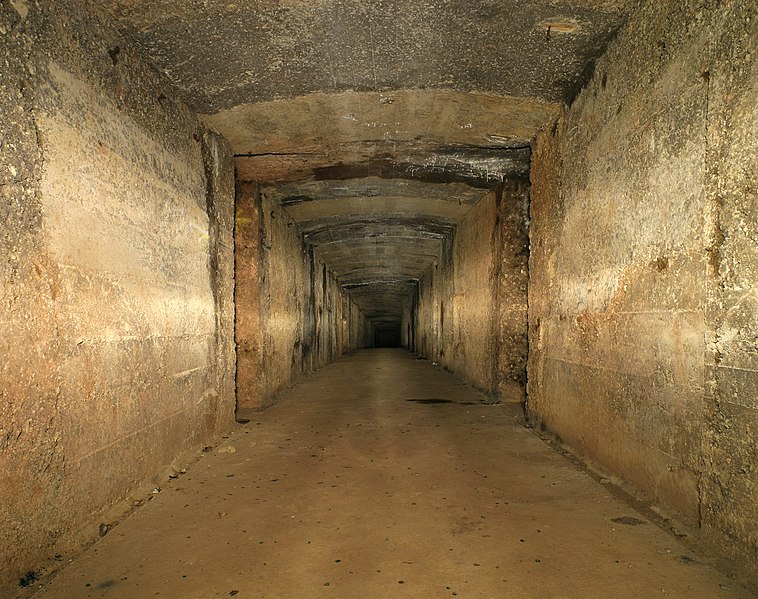
Français : Le casernement souterrain (situé sous le casernement de guerre (bétonné)).
Roppe fortifications, underground galleries (lightpainting). |
| 日期 | |
| 来源 | 自己的作品 |
| 作者 | User:ComputerHotline/about |
| 相机位置 | | 在以下服务上查看本图像和附近其他图像: OpenStreetMap |
|---|
评价
[编辑]
This image was selected as picture of the day on Wikimedia Commons for 8 February 2011. It was captioned as follows: English: Underground barracks located under concrete war barracks at Fort de Roppe (Roppe, Franche-Comté, France). Centered tunnel perspective made with light painting. Other languages:
Dansk: Underjordisk kaserne anlagt under betonkaserne i Fort de Roppe i Roppe, Franche-Comté, Frankrig. Deutsch: Gang in der unterirdischen Kaserne unter der Festungsanlage Fort de Roppe in Roppe in der der Region Franche-Comté (Frankreich) – im Light painting-Verfahren hergestellten Zentrierten Tunnelperspektive English: Underground barracks located under concrete war barracks at Fort de Roppe (Roppe, Franche-Comté, France). Centered tunnel perspective made with light painting. Español: Los barracones subterráneos (ubicados bajo los barracones de guerra) del Fort de Roppe (Roppe, Francia). Français : Le casernement souterrain (situé sous le casernement de guerre (bétonné)), au fort de Roppe (Roppe, France). Italiano: Galleria sotterranea nella caserma in cemento del Fort de Roppe, situato nella Franche-Comté, in Francia. L'immagine è stata ottenuta utilizzando la tecnica del light painting. Magyar: Föld alatti barakkok a Fort de Roppe melletti háborús betonbunkerek alatt (Franciaország, Franche-Comté, Roppe). Az alagút középre igazított látképe fényfestéssel készült. Македонски: Подземна касарна во Ропската тврдина (Роп, Франција). Українська: Підземні казарми, розташовані під бетонними військовими казармами Форту Роппе, Бельфор, Франція. 日本語: Fort de Roppe の地下兵舎(フランス、フランシュ=コンテ地域圏) 中文: 位于法国弗朗什孔特罗普堡的地下兵营 |
|

许可协议
[编辑]
本文件采用知识共享署名 3.0 未本地化版本许可协议授权。
- 您可以自由地:
- 共享 – 复制、发行并传播本作品
- 修改 – 改编作品
- 惟须遵守下列条件:
- 署名 – 您必须对作品进行署名,提供授权条款的链接,并说明是否对原始内容进行了更改。您可以用任何合理的方式来署名,但不得以任何方式表明许可人认可您或您的使用。
本文件使用Commonist.
文件历史
点击某个日期/时间查看对应时刻的文件。
| 日期/时间 | 缩略图 | 大小 | 用户 | 备注 | |
|---|---|---|---|---|---|
| 当前 | 2010年10月31日 (日) 16:53 | | 3,438 × 2,718(6.84 MB) | ComputerHotline(留言 | 贡献) |
您不可以覆盖此文件。
文件用途
以下41个页面使用本文件:
- Fort de Roppe (2)
- User:ComputerHotline/Archive 3
- User:ComputerHotline/Fort de Roppe
- Commons:Featured picture candidates/File:15-18-19-f-roppe-lp.jpg
- Commons:Featured picture candidates/Log/November 2010
- Commons:Featured pictures/Places/Interiors
- Commons:Featured pictures/chronological/2010-B
- Commons:Picture of the Year/2010/Galleries/Index/14
- Commons:Picture of the Year/2010/Galleries/Index/Interiors
- Commons:Picture of the Year/2010/Galleries/Interiors
- Commons:Picture of the Year/2010/Galleries/Interiors/Large
- Commons:Picture of the Year/2010/Galleries/Interiors/Small
- Commons:Picture of the Year/2010/Galleries/Table
- Commons:Picture of the Year/2010/Galleries/Table/11
- Commons:Picture of the Year/2010/R1/File:15-18-19-f-roppe-lp.jpg
- Commons:Picture of the Year/2010/Results/R1/ALL/Table
- Commons:Picture of the Year/2010/Results/R1/Interiors
- Commons:Picture of the Year/2010/Results/R1/Interiors/Table
- Commons:Potd/2011-02 (de)
- Commons:Potd/2011-02 (nl)
- Commons:Potd/2011-02 (pt)
- Commons:Quality images/Subject/Places/Man made structures/Buildings, Exterior/Part 1
- Commons:Quality images candidates/Archives November 2010
- Commons talk:Picture of the Year/2010/Galleries/Table
- Commons talk:Quality images/Subject/Places/Man made structures
- Template:Potd/2011-02
- Template:Potd/2011-02-08
- Template:Potd/2011-02-08 (da)
- Template:Potd/2011-02-08 (de)
- Template:Potd/2011-02-08 (en)
- Template:Potd/2011-02-08 (es)
- Template:Potd/2011-02-08 (fr)
- Template:Potd/2011-02-08 (hu)
- Template:Potd/2011-02-08 (it)
- Template:Potd/2011-02-08 (ja)
- Template:Potd/2011-02-08 (mk)
- Template:Potd/2011-02-08 (nl)
- Template:Potd/2011-02-08 (pt)
- Template:Potd/2011-02-08 (uk)
- Template:Potd/2011-02-08 (zh-hans)
- Template:Potd/2011-02 (zh-hans)
全域文件用途
以下其他wiki使用此文件:
- ba.wikipedia.org上的用途
- be-tarask.wikipedia.org上的用途
- be.wikipedia.org上的用途
- bn.wikipedia.org上的用途
- ca.wikipedia.org上的用途
- crh.wikipedia.org上的用途
- cv.wikipedia.org上的用途
- fa.wikipedia.org上的用途
- fr.wikipedia.org上的用途
- hu.wikipedia.org上的用途
- ko.wikipedia.org上的用途
- lbe.wikipedia.org上的用途
- mk.wikipedia.org上的用途
- os.wikipedia.org上的用途
- pl.wikipedia.org上的用途
- pt.wikipedia.org上的用途
- ru.wikipedia.org上的用途
- ru.wikinews.org上的用途
- sah.wikipedia.org上的用途
- uk.wikipedia.org上的用途
- vi.wikipedia.org上的用途
- xal.wikipedia.org上的用途
- zh.wikipedia.org上的用途