File:1652 Sanson Map of India - Geographicus - India-sanson-1652.jpg
পরিভ্রমণে চলুন
অনুসন্ধানে চলুন

এই প্রাকদর্শনের আকার: ৭৬২ × ৫৯৯ পিক্সেল। অন্যান্য আকারসমূহ: ৩০৫ × ২৪০ পিক্সেল | ৬১১ × ৪৮০ পিক্সেল | ৯৭৭ × ৭৬৮ পিক্সেল | ১,২৮০ × ১,০০৭ পিক্সেল | ২,৫০০ × ১,৯৬৬ পিক্সেল।
মূল ফাইল (২,৫০০ × ১,৯৬৬ পিক্সেল, ফাইলের আকার: ১.৪৫ মেগাবাইট, এমআইএমই ধরন: image/jpeg)
ক্যাপশনসমূহ
ক্যাপশন
এই ফাইল কি প্রতিনিধিত্ব করছে তার এক লাইন ব্যাখ্যা যোগ করুন
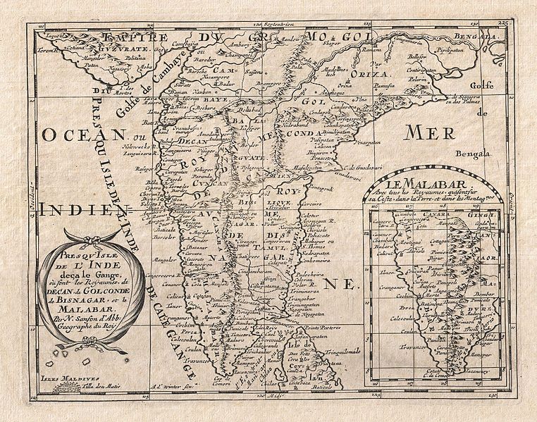
| Presqu'Isle de L'Inde deca le Gange, ou sont les Royaumes de Decan, de Golconde, de Bisnagar, et le Malabar. | ||||||
|---|---|---|---|---|---|---|
| শিল্পী | ||||||
| শিরোনাম |
Presqu'Isle de L'Inde deca le Gange, ou sont les Royaumes de Decan, de Golconde, de Bisnagar, et le Malabar. |
|||||
| বিবরণ |
English: A small but attractive 1652 map of India by the French cartographer Nicholas Sanson. Covers the subcontinent From the Bay of Bengal and the Gulf of Cambay to Ceylon (Sri Lanka). Offers impressive detail given that the interior of India was largely unknown to the west until the British survey's of the late 18th century. The vast Mogul Empire sprawls across the northern part of the map. Further south the kingdoms of Deccan, Malabar, Bisnagar, and Golconda, among others, are noted. As an indicator of how just out of date European knowledge of this region was, most of these kingdoms had fallen to ruin over 100 years prior to the publication of this map. The Portuguese enclave of Goa on India's west coast is noted. In the lower right quadrant there is an inset of the Malabar Coast. The lower left hand quadrant features a curious and speculative depiction of the Maldives. |
|||||
| তারিখ | ১৬৫২ (undated) | |||||
| আকার | উচ্চতা: ৮.০ ইঞ্চি (২০.৩ সে.মি.); প্রস্থ: ১০.০ ইঞ্চি (২৫.৪ সে.মি.) | |||||
| সংযোজন সংখ্যা |
Geographicus link: India-sanson-1652 |
|||||
| উৎস/আলোকচিত্রগ্রাহক |
Sanson D'Abbeville, Nicolas, L'Asie en Plusieurs Cartes & En Divers Traitez De Geographie, Et D'Histoire…, Paris: Chez l'auteur, 1652.
|
|||||
| অনুমতি (এ ফাইলের পুনঃব্যবহার) |
|
|||||
ফাইলের ইতিহাস
যেকোনো তারিখ/সময়ে ক্লিক করে দেখুন ফাইলটি তখন কী অবস্থায় ছিল।
| তারিখ/সময় | সংক্ষেপচিত্র | মাত্রা | ব্যবহারকারী | মন্তব্য | |
|---|---|---|---|---|---|
| বর্তমান | ০১:৩৮, ২৪ মার্চ ২০১১ | | ২,৫০০ × ১,৯৬৬ (১.৪৫ মেগাবাইট) | BotMultichillT (আলোচনা | অবদান) | {{subst:User:Multichill/Geographicus |link=http://www.geographicus.com/P/AntiqueMap/India-sanson-1652 |product_name=1652 Sanson Map of India |map_title=Presqu'Isle de L'Inde deca le Gange, ou sont les Royaumes de Decan, de Golconde, de Bisnagar, et le Mal |
আপনি এই ফাইলটি প্রতিস্থাপন করতে পারবেন না।
ফাইলের ব্যবহার
নিম্নলিখিত পাতাটি এই ফাইল ব্যবহার করে:
ফাইলের বৈশ্বিক ব্যবহার
নিচের অন্যান্য উইকিগুলো এই ফাইলটি ব্যবহার করে:
- af.wikipedia.org-এ ব্যবহার
- ar.wikipedia.org-এ ব্যবহার
- bn.wikipedia.org-এ ব্যবহার
- en.wikipedia.org-এ ব্যবহার
- sl.wikipedia.org-এ ব্যবহার
- ta.wikipedia.org-এ ব্যবহার