File:1657 Jansson Map of the Empire of Charlemagne - Geographicus - CaroliMagni-jansson-1657.jpg
Μετάβαση στην πλοήγηση
Πήδηση στην αναζήτηση

Μέγεθος αυτής της προεπισκόπησης: 800 × 584 εικονοστοιχεία . Άλλες αναλύσεις: 320 × 234 εικονοστοιχεία | 640 × 467 εικονοστοιχεία | 1.024 × 748 εικονοστοιχεία | 1.280 × 934 εικονοστοιχεία | 2.560 × 1.869 εικονοστοιχεία | 4.000 × 2.920 εικονοστοιχεία.
Πρωτότυπο αρχείο (4.000 × 2.920 εικονοστοιχεία, μέγεθος αρχείου: 3,72 MB, τύπος MIME: image/jpeg)
Λεζάντες
Λεζάντες
Δεν ορίστηκε λεζάντα
Σύνοψη
[επεξεργασία]
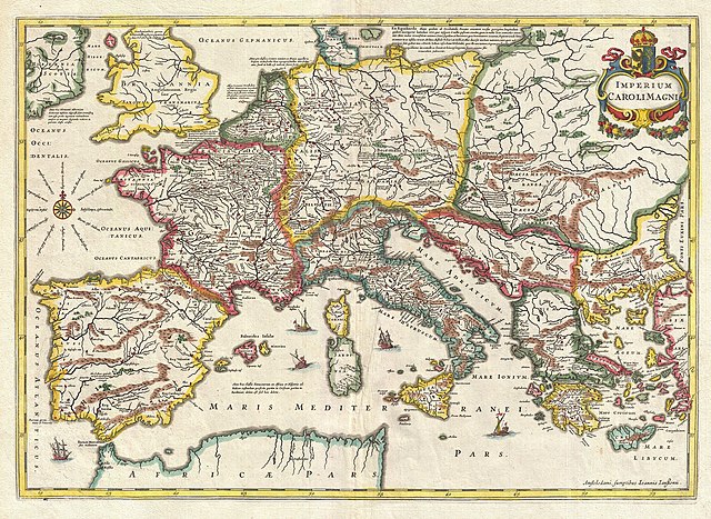
| Imperium Caroli Magni.
( |
||||||||||||||||||||||||||
|---|---|---|---|---|---|---|---|---|---|---|---|---|---|---|---|---|---|---|---|---|---|---|---|---|---|---|
| Καλλιτέχνης |
|
|||||||||||||||||||||||||
| Τίτλος |
Imperium Caroli Magni. |
|||||||||||||||||||||||||
| Περιγραφή |
English: This is a remarkable example of Jan Jansson's 1657 mapping of the Empire of Charlemagne. Covers from Spain to the Black Sea and from Denmark and Ireland to North Africa. Filled with copious notations in Latin. Decorative sailing vessels ply the Mediterranean. A decorative title cartouche appears in the upper right quadrant. This remarkable map was published in volume six, the Orbis Antiquus , of Jan Jansson's Novus Atlas . |
|||||||||||||||||||||||||
| Ημερομηνία | 1657 (undated) | |||||||||||||||||||||||||
| Διαστάσεις | ύψος: 15 ίντσες (38,1 cm)• πλάτος: 20,7 ίντσες (52,7 cm) | |||||||||||||||||||||||||
| Αριθμός καταχώρησης |
Geographicus link: CaroliMagni-jansson-1657 |
|||||||||||||||||||||||||
| Πηγή/φωτογράφος |
Jansson, J., Novus Atlas, Sive Theatrum Orbis Terrarum: In quo Orbis Antiquus, Seu Geographia Vetus, Sacra & Profana exhibetur, Volume 6, 1657.
|
|||||||||||||||||||||||||
| Άδεια (Επαναχρησιμοποίηση αυτού του αρχείου) |
|
|||||||||||||||||||||||||
Ιστορικό αρχείου
Πατήστε σε μια ημερομηνία/ώρα για να δείτε το αρχείο όπως εμφανιζόταν εκείνη την χρονική στιγμή.
| Ημερομηνία/Ώρα | Μικρογραφία | Διαστάσεις | Χρήστης | Σχόλιο | |
|---|---|---|---|---|---|
| τρέχον | 21:00, 23 Μαρτίου 2011 | | 4.000 × 2.920 (3,72 MB) | BotMultichillT (συζήτηση | Συνεισφορά) | {{subst:User:Multichill/Geographicus |link=http://www.geographicus.com/P/AntiqueMap/CaroliMagni-jansson-1657 |product_name=1657 Jansson Map of the Empire of Charlemagne |map_title=Imperium Caroli Magni. |description=This is a remarkable example of Jan Jan |
Δεν μπορείτε να αντικαταστήσετε αυτό το αρχείο.
Χρήση αρχείου
Η ακόλουθη σελίδα χρησιμοποιεί προς αυτό το αρχείο:
Καθολική χρήση αρχείου
Τα ακόλουθα άλλα wiki χρησιμοποιούν αυτό το αρχείο:
- Χρήση σε el.wikipedia.org
- Χρήση σε hr.wikipedia.org
- Χρήση σε sh.wikipedia.org