File:16U 2023 track.png
跳至導覽
跳至搜尋

預覽大小:800 × 495 像素。 其他解析度:320 × 198 像素 | 640 × 396 像素 | 1,024 × 633 像素 | 1,280 × 791 像素 | 2,700 × 1,669 像素。
原始檔案 (2,700 × 1,669 像素,檔案大小:3.95 MB,MIME 類型:image/png)
說明
說明
添加單行說明來描述出檔案所代表的內容
摘要
| 描述 |
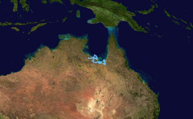
English: Track map of Tropical Low 16U of the 2022-23 Australian region cyclone season. The points show the location of the storm at 6-hour intervals. The colour represents the storm's maximum sustained wind speeds as classified in the (see below), and the shape of the data points represent the nature of the storm, according to the legend below. Tropical depression (≤38 mph, ≤62 km/h)
Tropical storm (39–73 mph, 63–118 km/h)
Category 1 (74–95 mph, 119–153 km/h)
Category 2 (96–110 mph, 154–177 km/h)
Category 3 (111–129 mph, 178–208 km/h)
Category 4 (130–156 mph, 209–251 km/h)
Category 5 (≥157 mph, ≥252 km/h)
Unknown
Storm type |
| 日期 | 2023-03-04–2023-03-09 |
| 來源 |
Created by Meow using Wikipedia:WikiProject Tropical cyclones/Tracks. The background image is from NASA. Tracking data is from NOAA ( |
| 作者 | Meow |
| 其他版本 |
|

授權條款
[編輯]| 此作品已由其作者,Meow,釋出至公有領域。此授權條款在全世界均適用。 這可能在某些國家不合法,如果是的話: Meow授予任何人有權利使用此作品於任何用途,除受法律約束外,不受任何限制。 |
檔案歷史
點選日期/時間以檢視該時間的檔案版本。
| 日期/時間 | 縮圖 | 尺寸 | 使用者 | 備註 | |
|---|---|---|---|---|---|
| 目前 | 2023年3月9日 (四) 15:07 | | 2,700 × 1,669(3.95 MB) | Meow(留言 | 貢獻) | 03-09 00Z |
| 2023年3月8日 (三) 13:14 |  | 2,700 × 1,669(3.97 MB) | Meow(留言 | 貢獻) | 03-08 12Z | |
| 2023年3月7日 (二) 13:20 |  | 2,700 × 1,669(3.95 MB) | Meow(留言 | 貢獻) | 03-07 12Z | |
| 2023年2月23日 (四) 13:06 |  | 2,700 × 1,669(2.72 MB) | Meow(留言 | 貢獻) | {{WPTC track map | author = Meow | name = Tropical Low 16U | article = 2022–23 Australian region cyclone season#Tropical Low 16U | season = 2022-23 Australian region cyclone season | start = 2023-02-22 | end = | othersource = [https://www.ssd.noaa.gov/PS/TROP/DATA/ATCF/JTWC/bsh952023.dat NOAA] }} |
無法覆蓋此檔案。
檔案用途
下列頁面有用到此檔案:
全域檔案使用狀況
以下其他 wiki 使用了這個檔案:
- ko.wikipedia.org 的使用狀況
- pt.wikipedia.org 的使用狀況
- zh.wikipedia.org 的使用狀況