File:1746 Homann Heirs Map of South ^ North America - Geographicus - Americae-hmhr-1746.jpg
ナビゲーションに移動
検索に移動

このプレビューのサイズ: 686 × 599 ピクセル。 その他の解像度: 275 × 240 ピクセル | 550 × 480 ピクセル | 879 × 768 ピクセル | 1,172 × 1,024 ピクセル | 2,345 × 2,048 ピクセル | 4,000 × 3,494 ピクセル。
元のファイル (4,000 × 3,494 ピクセル、ファイルサイズ: 3.91メガバイト、MIME タイプ: image/jpeg)
キャプション
キャプション
このファイルの内容を1行で記述してください
| Americae Mappa Generalis. | ||||||
|---|---|---|---|---|---|---|
| 作者 | ||||||
| タイトル |
Americae Mappa Generalis. |
|||||
| 解説 |
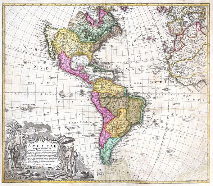
English: A stunning 1746 Homann Heirs hand colored map of both North and South America. This is the second issue of this important map following the earlier edition by J. B. Homann. Map reflects a considerable advancement in American cartography of the time as well as a general increase in knowledge regarding America’s interior from explorations and colonizations. Map immediately precedes the French and Indian War, so the French are shown to dominate North American while the Spanish are preeminent in the south. The Pacific Northwest is largely unexplored, but nonetheless, the mythical Northwest Passage is shown. As is the mythical Quivira, “Land of Gold and Silver”, sought after by conquistador Francisco de Coronado in 1541. The beautiful decorative title cartouche in the lower left quadrant depicts two erupting volcanoes and several American Indians, one of which is seems to be holding aloft a shrunken head or similar idol. An important early map of the Americas. |
|||||
| 日付 | 1746年 | |||||
| 寸法 | 高さ: 18.5 in (46.9 cm);幅: 21.5 in (54.6 cm) | |||||
| 台帳番号 |
Geographicus link: Americae-hmhr-1746 |
|||||
| 情報源/撮影者 |
|
|||||
| 許可 (ファイルの再利用) |
|
|||||
ファイルの履歴
過去の版のファイルを表示するには、その版の日時をクリックしてください。
| 日付と時刻 | サムネイル | 寸法 | 利用者 | コメント | |
|---|---|---|---|---|---|
| 現在の版 | 2011年3月24日 (木) 09:15 | | 4,000 × 3,494 (3.91メガバイト) | BotMultichillT (トーク | 投稿記録) | {{subst:User:Multichill/Geographicus |link=http://www.geographicus.com/P/AntiqueMap/Americae-hmhr-1746 |product_name=1746 Homann Heirs Map of South & North America |map_title=Americae Mappa Generalis. |description=A stunning 1746 Homann Heirs hand colored |
このファイルは上書きできません。
ファイルの使用状況
以下のページがこのファイルを使用しています:
グローバルなファイル使用状況
以下に挙げる他のウィキがこの画像を使っています:
- ja.wikipedia.org での使用状況