File:1771 Bonne Map of Tonkin (Vietnam) China, Formosa (Taiwan) and Luzon (Philippines) - Geographicus - Formosa-bonne-1771.jpg
Spring til navigation
Spring til søgning
Størrelse af denne forhåndsvisning: 800 × 583 pixels. Andre opløsninger: 320 × 233 pixels | 640 × 466 pixels | 1.024 × 746 pixels | 1.280 × 933 pixels | 2.560 × 1.866 pixels | 4.000 × 2.915 pixels.
Oprindelig fil (4.000 × 2.915 billedpunkter, filstørrelse: 3,17 MB, MIME-type: image/jpeg)
Captions
Captions
Tilføj en kort forklaring på en enkelt linje om hvad filen viser
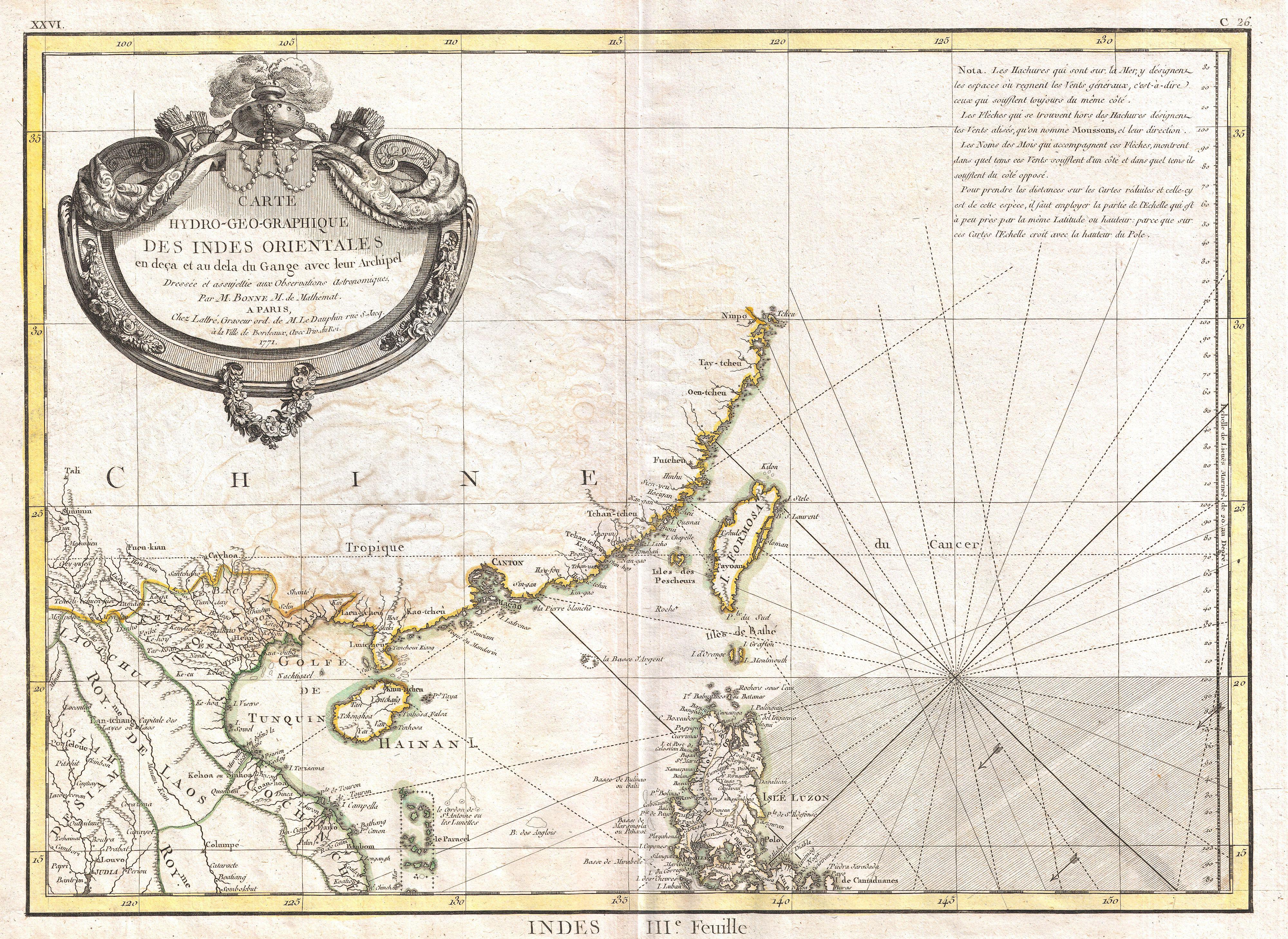
| Rigobert Bonne: Carte Hydro-Geo-Graphique des Indes Orientales en deca et au dela du Gange avec leur Archipel Dressee et assujettie aux Observations Astronomiques.
( |
|||||||||||||||||||||||
|---|---|---|---|---|---|---|---|---|---|---|---|---|---|---|---|---|---|---|---|---|---|---|---|
| Kunstner |
|
||||||||||||||||||||||
| Titel |
Carte Hydro-Geo-Graphique des Indes Orientales en deca et au dela du Gange avec leur Archipel Dressee et assujettie aux Observations Astronomiques. |
||||||||||||||||||||||
| Beskrivelse |
English: A beautiful example of Rigobert Bonne's 1771 uncommon map of southeastern China. Covers from the Kingdom of Siam (Thailand) to include Laos, Tonkin (northern Vietnam), Cochin Chi (southern Vietnam), the island of Hainan, Formosa (Taiwan) and the Island of Luzon (northern Philippines). Notes Macao and Canton and shows, but does not label, Hong Kong Island. Tayoan is noted on Formosa. Offers little inland detail with regard to China itself. Notes in the upper right hand corner comment on the Monsoons. Rhumb lines throughout. Arrows in the lower right show the direction of the prevailing winds. A fine map of the region. Drawn by R. Bonne in 1771 for issue as plate no. C 26 in Jean Lattre's 1776 issue of the Atlas Moderne . |
||||||||||||||||||||||
| Dato | 1771 (dated) | ||||||||||||||||||||||
| Mål | højde: 12 in (30,4 cm); bredde: 16,5 in (41,9 cm) | ||||||||||||||||||||||
| Museumsnummer |
Geographicus link: Formosa-bonne-1771 |
||||||||||||||||||||||
| Kilde/Fotograf |
Lattre, Jean, Atlas Moderne ou Collection de Cartes sur Toutes les Parties du Globe Terrestre, c. 1775.
|
||||||||||||||||||||||
| Tilladelse (Genbrug af denne fil) |
|
||||||||||||||||||||||
| Andre versioner | |||||||||||||||||||||||
.jpg)
_map_by_Bonne.jpg)
Filhistorik
Klik på en dato/tid for at se filen som den så ud på det tidspunkt.
| Dato/tid | Miniaturebillede | Dimensioner | Bruger | Kommentar | |
|---|---|---|---|---|---|
| nuværende | 23. mar. 2011, 02:47 | | 4.000 × 2.915 (3,17 MB) | BotMultichillT (diskussion | bidrag) | {{subst:User:Multichill/Geographicus |link=http://www.geographicus.com/P/AntiqueMap/Formosa-bonne-1771 |product_name=1771 Bonne Map of Tonkin (Vietnam) China, Formosa (Taiwan) and Luzon (Philippines) |map_title=Carte Hydro-Geo-Graphique des Indes Oriental |
Du kan ikke overskrive denne fil.
Filanvendelse
De følgende 3 sider bruger denne fil:
_China,_Formosa_(Taiwan)_and_Luzon_(Philippines)_-_Geographicus_-_Formosa-bonne-1771.jpg)
Global filanvendelse
Følgende andre wikier anvender denne fil:
- Anvendelser på en.wikipedia.org
- Anvendelser på id.wikipedia.org
- Anvendelser på www.wikidata.org
- Anvendelser på zh.wikipedia.org
_China,_Formosa_(Taiwan)_and_Luzon_(Philippines)_-_Geographicus_-_Formosa-bonne-1771.jpg&oldid=744719127)