File:1771 Bonne Map of the Guinea Coast of West Africa and the Cape Verde Islands - Geographicus - Guinea-bonne-1771.jpg
Zur Navigation springen
Zur Suche springen

Größe dieser Vorschau: 439 × 599 Pixel. Weitere Auflösungen: 176 × 240 Pixel | 352 × 480 Pixel | 563 × 768 Pixel | 751 × 1.024 Pixel | 1.502 × 2.048 Pixel | 2.933 × 4.000 Pixel.
Originaldatei (2.933 × 4.000 Pixel, Dateigröße: 2,29 MB, MIME-Typ: image/jpeg)
Bildtexte
Kurzbeschreibungen
Ergänze eine einzeilige Erklärung, was diese Datei darstellt.
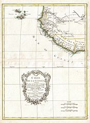
| Rigobert Bonne: Carte de la Guinee contenant les Isles du Cap Verd, le Senegal, la Cote de Guinee proprement dite, les Royaumes de Loango, Congo, Angola, et Benguela avec les Pays voisins autant qu'ils sont connus.
( |
|||||||||||||||||||||||
|---|---|---|---|---|---|---|---|---|---|---|---|---|---|---|---|---|---|---|---|---|---|---|---|
| Künstler |
|
||||||||||||||||||||||
| Titel |
Carte de la Guinee contenant les Isles du Cap Verd, le Senegal, la Cote de Guinee proprement dite, les Royaumes de Loango, Congo, Angola, et Benguela avec les Pays voisins autant qu'ils sont connus. |
||||||||||||||||||||||
| Beschreibung |
English: A beautiful example of Rigobert Bonne's c. 1770 decorative map of western Africa. Covers from the Cape Verde Islands eastward to the coasts of Africa and the western mouth of the Niger River. Includes the modern day nations of Mauritania, Senegal, Gambia, Guinea-Bissau, Guinea, Sierra Leone, Liberia and Cote d'Ivoire. A decorative title cartouche appears in the lower left hand quadrant. Drawn by R. Bonne in 1770 for issue as plate no. A 30 in Jean Lattre's 1776 issue of the Atlas Moderne . |
||||||||||||||||||||||
| Datum | 1771 (dated) | ||||||||||||||||||||||
| Maße | Höhe: 17 in (43,1 cm); Breite: 13 in (33 cm) | ||||||||||||||||||||||
| Inventarnummer |
Geographicus link: Guinea-bonne-1771 |
||||||||||||||||||||||
| Herkunft/Fotograf |
Lattre, Jean, Atlas Moderne ou Collection de Cartes sur Toutes les Parties du Globe Terrestre, c. 1775.
|
||||||||||||||||||||||
| Genehmigung (Weiternutzung dieser Datei) |
|
||||||||||||||||||||||
| Andere Versionen | |||||||||||||||||||||||

Dateiversionen
Klicke auf einen Zeitpunkt, um diese Version zu laden.
| Version vom | Vorschaubild | Maße | Benutzer | Kommentar | |
|---|---|---|---|---|---|
| aktuell | 03:17, 23. Mär. 2011 | | 2.933 × 4.000 (2,29 MB) | BotMultichillT (Diskussion | Beiträge) | {{subst:User:Multichill/Geographicus |link=http://www.geographicus.com/P/AntiqueMap/Guinea-bonne-1771 |product_name=1771 Bonne Map of the Guinea Coast of West Africa and the Cape Verde Islands |map_title=Carte de la Guinee contenant les Isles du Cap Verd, |
Du kannst diese Datei nicht überschreiben.
Dateiverwendung
Die folgenden 2 Seiten verwenden diese Datei:
Globale Dateiverwendung
Die nachfolgenden anderen Wikis verwenden diese Datei:
- Verwendung auf en.wikipedia.org
- Verwendung auf es.wikipedia.org
- Verwendung auf fr.wikipedia.org
- Verwendung auf he.wikipedia.org
- Verwendung auf uk.wikipedia.org
- Verwendung auf zh.wikipedia.org