File:1793 Faden Wall Map of India - Geographicus - India-faden-1793.jpg
ナビゲーションに移動
検索に移動

このプレビューのサイズ: 497 × 599 ピクセル。 その他の解像度: 199 × 240 ピクセル | 398 × 480 ピクセル | 637 × 768 ピクセル | 850 × 1,024 ピクセル | 1,700 × 2,048 ピクセル | 6,000 × 7,229 ピクセル。
元のファイル (6,000 × 7,229 ピクセル、ファイルサイズ: 9.83メガバイト、MIME タイプ: image/jpeg)
キャプション
キャプション
このファイルの内容を1行で記述してください
| A Map of the Peninsula of India. | ||||||
|---|---|---|---|---|---|---|
| 作者 | ||||||
| タイトル |
A Map of the Peninsula of India. |
|||||
| 解説 |
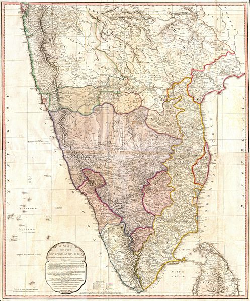
English: This map, created immediately after the Third Anglo-Mysore War (1789-92), shows the division of and territorial loss by the Kingdom of Mysore through the 1792 Treaty of Seringapatam.
A "third edition" was created in 1800 showing the territorial changes after the Fourth Anglo-Mysore War (1798–1799). Description from Geographicus: One of the largest and most impressive maps of India to appear in the 18th century. Depicts the subcontinent from Bombay ( Mumbai ) and Aurungabad, south including the northern half of Sri Lanka ( Ceylon ). Printed in 1793 in London by William Faden, “Royal Geographer to the King and to the Prince of Wales”. Includes the routes of various military marches and campaigns including the 1784 March of British Prisoners from Condapoor to Madras, the march of the Marquis of Cornwallis, the march of General Medows, and the march of General Abercromby. Also shows the acquisitions of the British through the Partition Treaty of 1792. The whole is masterfully presented in visually stunning almost three dimensional detail and stunning period color. A must for any serious collection of south Asia maps. Compiled chiefly from papers communicated by the late Sir Archd. Campbell, the surveys of Col. Kelly, Capt. Pringle, Capt. Allan, etc. |
|||||
| 日付 | 1793年 (dated) | |||||
| 寸法 | 高さ: 39 in (99 cm);幅: 32 in (81.2 cm) | |||||
| 台帳番号 |
Geographicus link: India-faden-1793 |
|||||
| 情報源/撮影者 |
|
|||||
| 許可 (ファイルの再利用) |
|
|||||
| その他のバージョン |
|
|||||

ファイルの履歴
過去の版のファイルを表示するには、その版の日時をクリックしてください。
| 日付と時刻 | サムネイル | 寸法 | 利用者 | コメント | |
|---|---|---|---|---|---|
| 現在の版 | 2011年3月24日 (木) 10:16 | | 6,000 × 7,229 (9.83メガバイト) | BotMultichillT (トーク | 投稿記録) | {{subst:User:Multichill/Geographicus |link=http://www.geographicus.com/P/AntiqueMap/India-faden-1793 |product_name=1793 Faden Wall Map of India |map_title=A Map of the Peninsula of India. |description=One of the largest and most impressive maps of India t |
このファイルは上書きできません。
ファイルの使用状況
以下の 2 ページがこのファイルを使用しています:
グローバルなファイル使用状況
以下に挙げる他のウィキがこの画像を使っています:
- ar.wikipedia.org での使用状況
- azb.wikipedia.org での使用状況
- br.wikipedia.org での使用状況
- ca.wikipedia.org での使用状況
- de.wikipedia.org での使用状況
- en.wikipedia.org での使用状況
- es.wikipedia.org での使用状況
- fa.wikipedia.org での使用状況
- fr.wikipedia.org での使用状況
- it.wikipedia.org での使用状況
- ja.wikipedia.org での使用状況
- ml.wikipedia.org での使用状況
- mr.wikipedia.org での使用状況
- pa.wikipedia.org での使用状況
- pnb.wikipedia.org での使用状況
- ru.wikipedia.org での使用状況
- ta.wikipedia.org での使用状況
- te.wikipedia.org での使用状況
- uk.wikipedia.org での使用状況
- ur.wikipedia.org での使用状況
カテゴリ:
- Maps by William Faden
- James Rennell
- Old maps of South India
- 1793 maps of India
- 1792 maps of India
- 1791 maps of India
- 1790 maps of India
- 1789 maps of India
- Third Anglo-Mysore War
- British East India Company
- Old maps of Karnataka
- Maps of the Kingdom of Mysore
- Maps of the Anglo-Mysore wars
- Old maps of Kerala
- Old maps of Andhra Pradesh
- 1793 in Andhra Pradesh
- 1793 in Kerala
- 1793 in Mysore
- Historical images of Aurangabad