File:1845 Logerot Jigsaw Puzzle Atlas of the World - Geographicus - Atlas-logerot-1845.jpg
跳至導覽
跳至搜尋

預覽大小:800 × 581 像素。 其他解析度:320 × 233 像素 | 640 × 465 像素 | 1,024 × 744 像素 | 1,280 × 930 像素 | 2,560 × 1,861 像素 | 6,000 × 4,361 像素。
原始檔案 (6,000 × 4,361 像素,檔案大小:5.15 MB,MIME 類型:image/jpeg)
說明
說明
添加單行說明來描述出檔案所代表的內容
| Atlas. | ||||||
|---|---|---|---|---|---|---|
| 作家 | ||||||
| 標題 |
Atlas. |
|||||
| 描述 |
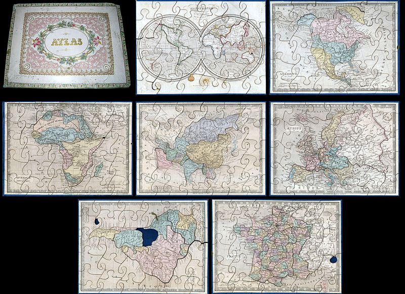
English: A very attractive an unusual c. 1850 jigsaw puzzle atlas published by Auguste Logerot. Consists a custom box of seven interesting jigsaw puzzle maps: the World, North America, South America, Europe, Asia, Africa and France. Each map is mounted on a board and dissected as a jigsaw puzzle. States and regions are individually dissected along their boundaries while oceans are dissected into more traditional jigsaw puzzle patterns. Individually the maps are based upon Dyonnet’s engravings for A. R. Fremin’s geography. The North American map is probably the most interesting showing Mexico’s claims to much of what is today the American Southwest, including the modern day states of California, Arizona, New Mexico, Nevada, Colorado and Utah. Texas is colored as part of the United States but looking closely one can see that it is clearly drawn as a separate independent nation. Also shows the U.S. claims to British Columbia, to the latitude of 54°40', prior to the Oregon Treat. The Africa map exhibits the somewhat limited knowledge of Africa’s interior in the early 19th century. Coastal areas are well mapped by the interior is somewhat vague. Various tribes are noted but none of the Rift Valley lakes appear. Missing a small piece on the Horn. The world map is a beautifully drawn hemispherical projection. Labels Australia as New Holland. Missing a tiny chunk near New Guinea. The map of France is divided according to departments. Missing small chunk in the lower right quadrant. South America map is missing the Bolivia piece and a small chunk in the lower left quadrant. Puzzle maps like this were first made in London by John Spilsbury in the 1760s. The style passed to the continent and became a popular educational tool in France and Germany in the early to mid 19th century. While rare and often in poor condition, these curious maps and atlases are among the most amusing and whimsical geographic themed educational devices to appear in the 19th century. |
|||||
| 日期 | 約1850年(undated) | |||||
| 尺寸 | 高度:8英寸(20.3公分);寬度:11英寸(27.9公分) | |||||
| 登錄號 |
Geographicus link: Atlas-logerot-1845 |
|||||
| 來源/攝影者 |
Logerot, A., Atlas, c. 1850.
|
|||||
| 授權許可 (重用此檔案) |
|
|||||
檔案歷史
點選日期/時間以檢視該時間的檔案版本。
| 日期/時間 | 縮圖 | 尺寸 | 使用者 | 備註 | |
|---|---|---|---|---|---|
| 目前 | 2011年3月22日 (二) 16:25 | | 6,000 × 4,361(5.15 MB) | BotMultichillT(留言 | 貢獻) | {{subst:User:Multichill/Geographicus |link=http://www.geographicus.com/P/AntiqueMap/Atlas-logerot-1845 |product_name=1845 Logerot Jigsaw Puzzle Atlas of the World |map_title=Atlas. |description=A very attractive an unusual c. 1850 jigsaw puzzle atlas publ |
無法覆蓋此檔案。
檔案用途
下列頁面有用到此檔案:
全域檔案使用狀況
以下其他 wiki 使用了這個檔案: