File:1847 Levasseur Map of Africa - Geographicus - Africa-levasseur-1847.jpg
ナビゲーションに移動
検索に移動
このプレビューのサイズ: 800 × 577 ピクセル。 その他の解像度: 320 × 231 ピクセル | 640 × 462 ピクセル | 1,024 × 739 ピクセル | 1,280 × 924 ピクセル | 2,560 × 1,847 ピクセル | 4,000 × 2,886 ピクセル。
元のファイル (4,000 × 2,886 ピクセル、ファイルサイズ: 4.01メガバイト、MIME タイプ: image/jpeg)
キャプション
キャプション
このファイルの内容を1行で記述してください
| Afrique. | ||||||||||||||||||||||||||||||||||||
|---|---|---|---|---|---|---|---|---|---|---|---|---|---|---|---|---|---|---|---|---|---|---|---|---|---|---|---|---|---|---|---|---|---|---|---|---|
| 作者 |
|
|||||||||||||||||||||||||||||||||||
| タイトル |
Afrique. |
|||||||||||||||||||||||||||||||||||
| 解説 |
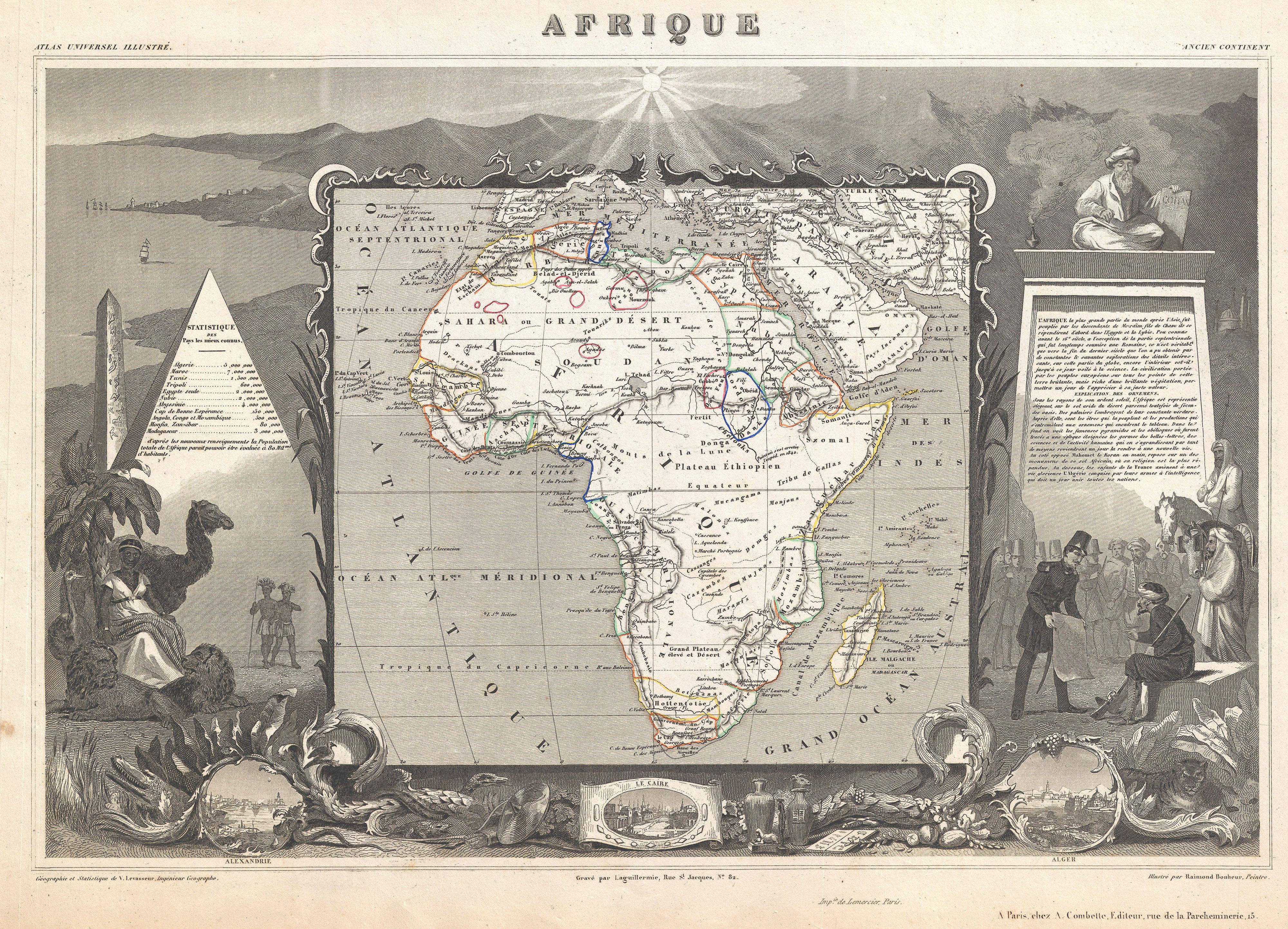
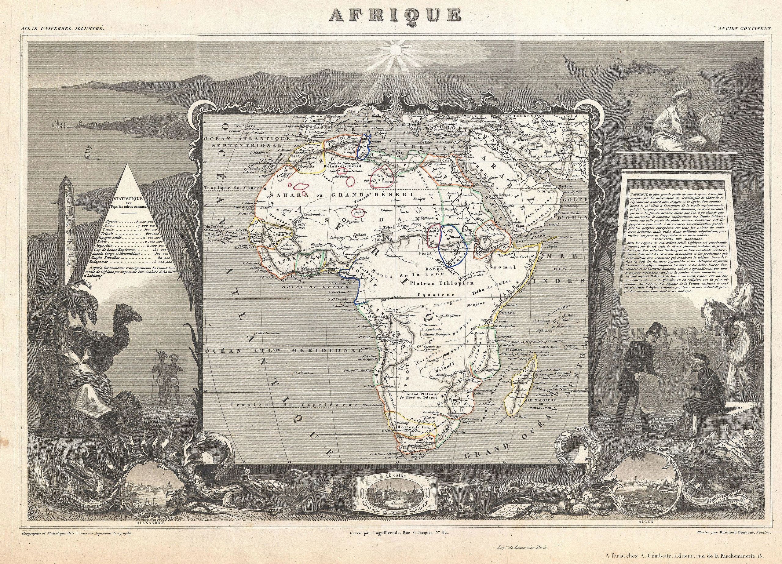
English: A stunning c. 1847 map of Africa by French cartographer Victor Levasseur. Depicts the entire continent with several interesting elements. A large lake appears in Mozambique which can only be Lake Malawi (Lake Nyasa). Lake Chad (Tchad) is also shown. Names numerous African kingdoms including Monomotapa and the Hottentots. Surrounded by the elaborate borders for which Levasseur is best known. Shows a stylized pyramid and obelisk, an imam, a French soldier consulting with Arabs, and three city vies: Alexandria, Cairo and Algiers. Prepared and published for V. Levasseur's magnificent c. 1847 Atlas Universel Illustre , one of the last decorative atlases of the 19th century. |
|||||||||||||||||||||||||||||||||||
| 日付 | 1847年頃(undated) | |||||||||||||||||||||||||||||||||||
| 寸法 | 高さ: 12.5 in (31.7 cm);幅: 18 in (45.7 cm) | |||||||||||||||||||||||||||||||||||
| 台帳番号 |
Geographicus link: Africa-levasseur-1847 |
|||||||||||||||||||||||||||||||||||
| 情報源/撮影者 |
Levasseur, V., Atlas Universel Illustre, c. 1847.
|
|||||||||||||||||||||||||||||||||||
| 許可 (ファイルの再利用) |
|
|||||||||||||||||||||||||||||||||||
ファイルの履歴
過去の版のファイルを表示するには、その版の日時をクリックしてください。
| 日付と時刻 | サムネイル | 寸法 | 利用者 | コメント | |
|---|---|---|---|---|---|
| 現在の版 | 2011年3月22日 (火) 22:59 | | 4,000 × 2,886 (4.01メガバイト) | BotMultichillT (トーク | 投稿記録) | {{subst:User:Multichill/Geographicus |link=http://www.geographicus.com/P/AntiqueMap/Africa-levasseur-1847 |product_name=1847 Levasseur Map of Africa |map_title=Afrique. |description=A stunning c. 1847 map of Africa by French cartographer Victor Levasseur. |
このファイルは上書きできません。
ファイルの使用状況
以下のページがこのファイルを使用しています:
グローバルなファイル使用状況
以下に挙げる他のウィキがこの画像を使っています:
- ja.wikipedia.org での使用状況
- www.wikidata.org での使用状況