File:1852 Levasseur Map of the Department Hautes Alpes, France - Geographicus - HautesAlpes-levasseur-1852.jpg
Aller à la navigation
Aller à la recherche

Taille de cet aperçu : 800 × 565 pixels. Autres résolutions : 320 × 226 pixels | 640 × 452 pixels | 1 024 × 724 pixels | 1 280 × 905 pixels | 2 560 × 1 810 pixels | 3 500 × 2 474 pixels.
Fichier d’origine (3 500 × 2 474 pixels, taille du fichier : 3,06 Mio, type MIME : image/jpeg)
Légendes
Légendes
Ajoutez en une ligne la description de ce que représente ce fichier
| Dept. Des Hautes Alpes. | ||||||||||||||||||||||||||||||||||||
|---|---|---|---|---|---|---|---|---|---|---|---|---|---|---|---|---|---|---|---|---|---|---|---|---|---|---|---|---|---|---|---|---|---|---|---|---|
| Artiste |
|
|||||||||||||||||||||||||||||||||||
| Titre |
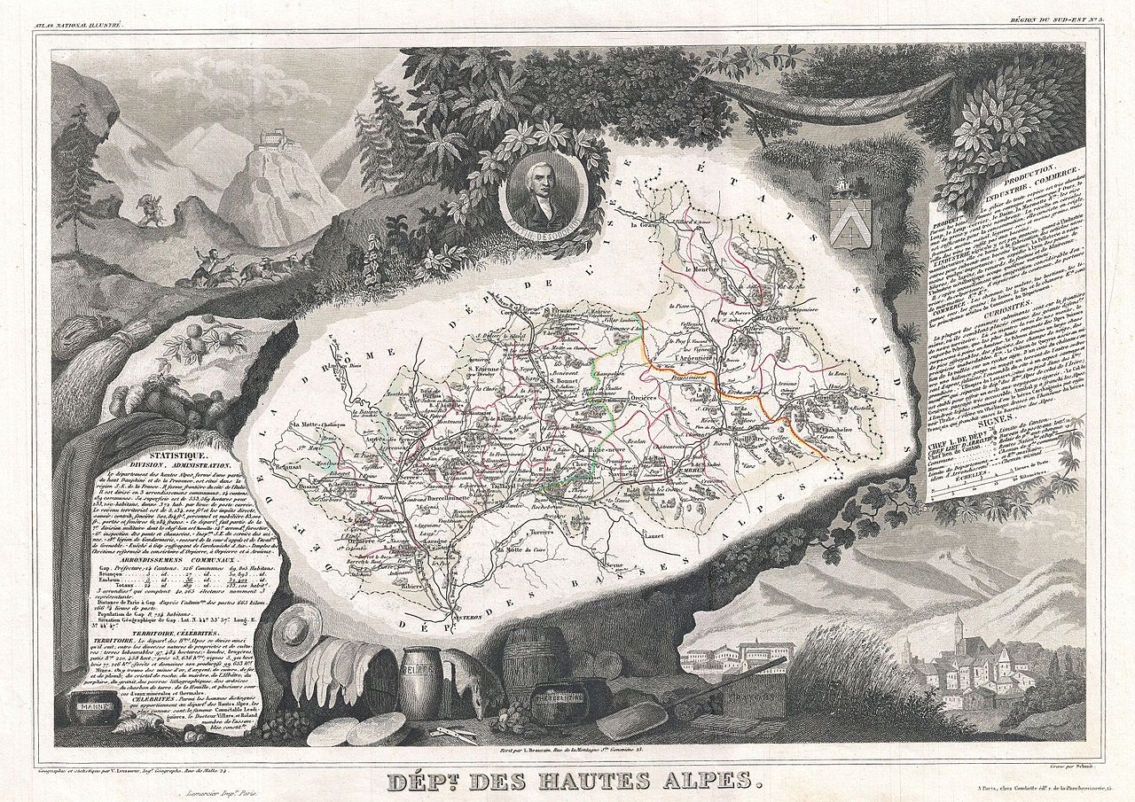
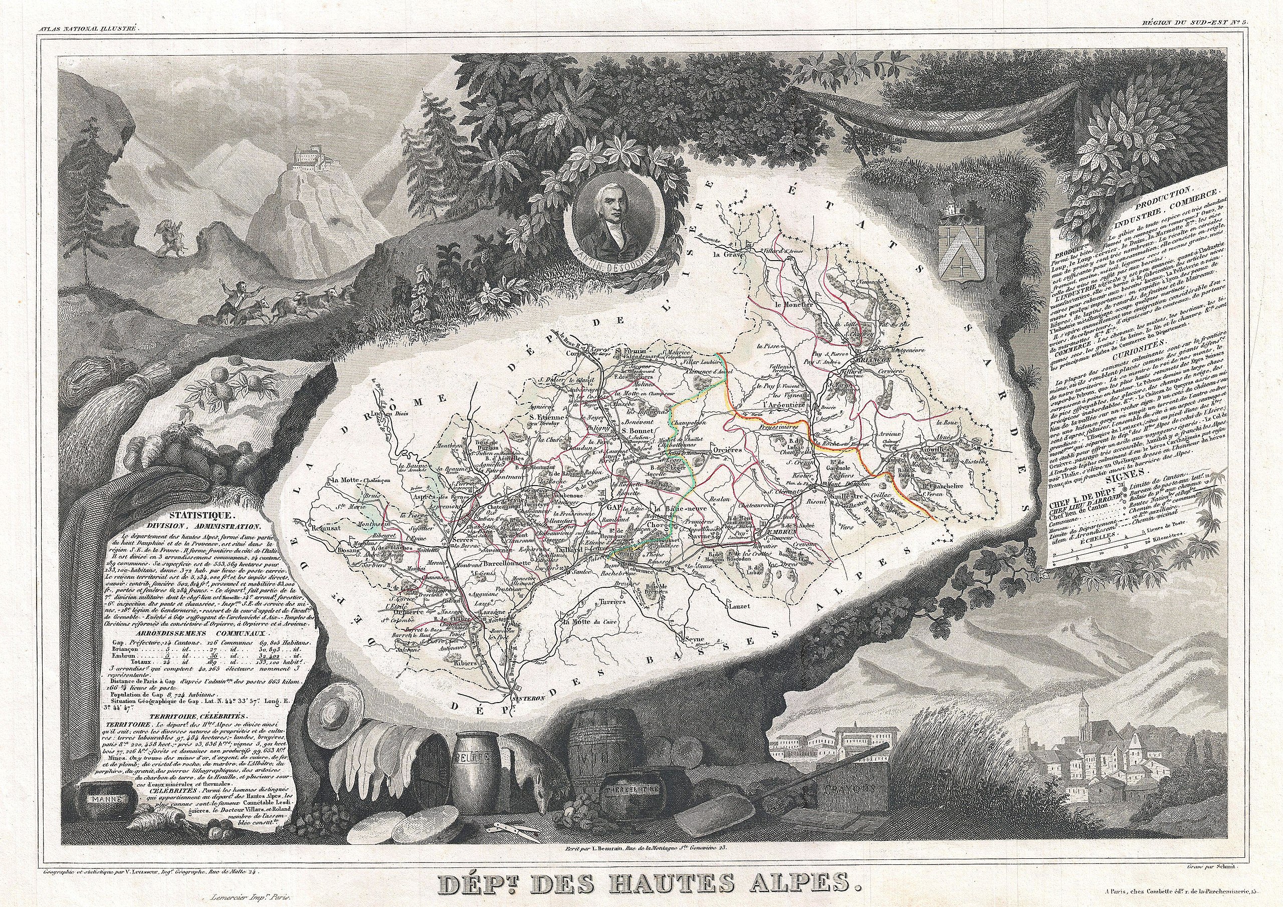
Dept. Des Hautes Alpes. |
|||||||||||||||||||||||||||||||||||
| Description |
English: This is a fascinating 1857 map of the French department of Hautes Alpes, France. This area of France is known for its production of Coteaux and Collines Rhodaniennes wines. The area is also famous for its chestnuts. The whole is surrounded by elaborate decorative engravings designed to illustrate both the natural beauty and trade richness of the land. There is a short textual history of the regions depicted on both the left and right sides of the map. Published by V. Levasseur in the 1852 edition of his Atlas National de la France Illustree. |
|||||||||||||||||||||||||||||||||||
| Date | 1852 (undated) | |||||||||||||||||||||||||||||||||||
| Dimensions | hauteur : 12,5 pouces (31,7 cm) ; largeur : 17 pouces (43,1 cm) | |||||||||||||||||||||||||||||||||||
| Numéro d’inventaire |
liens Geographicus : HautesAlpes-levasseur-1852 |
|||||||||||||||||||||||||||||||||||
| Source / photographe |
Levassuer, V., Atlas National Illustre des 86 Departements et des Possessions de La France Divise par Arrondissements, Cantons et Communea avec La Trace de Toutes Les Routes, Chemins,de fer et Canaux., 1852 edition.
|
|||||||||||||||||||||||||||||||||||
| Autorisation (Réutilisation de ce fichier) |
|
|||||||||||||||||||||||||||||||||||
Historique du fichier
Cliquer sur une date et heure pour voir le fichier tel qu'il était à ce moment-là.
| Date et heure | Vignette | Dimensions | Utilisateur | Commentaire | |
|---|---|---|---|---|---|
| actuel | 24 mars 2011 à 03:12 | | 3 500 × 2 474 (3,06 Mio) | BotMultichillT (d | contributions) | {{subst:User:Multichill/Geographicus |link=http://www.geographicus.com/P/AntiqueMap/HautesAlpes-levasseur-1852 |product_name=1852 Levasseur Map of the Department Hautes Alpes, France |map_title=Dept. Des Hautes Alpes. |description=This is a fascinating 18 |
Vous ne pouvez pas remplacer ce fichier.
Utilisations locales du fichier
La page suivante utilise ce fichier :
Utilisations du fichier sur d’autres wikis
Les autres wikis suivants utilisent ce fichier :
- Utilisation sur fr.wikipedia.org