File:1853 Mitchell Map of Turkey in Europe and Greece ( Greece, Balkans, Macedonia ) - Geographicus - TurkeyEurope-mitchell-1850.jpg
Pereiti į navigaciją
Jump to search

Šios peržiūros dydis: 489 × 600 taškų. Kitos 5 rezoliucijos: 196 × 240 taškų | 391 × 480 taškų | 626 × 768 taškų | 834 × 1 024 taškų | 2 445 × 3 000 taškų.
Pradinė rinkmena (2 445 × 3 000 taškų, rinkmenos dydis: 2,91 MiB, MIME tipas: image/jpeg)
Captions
Captions
Add a one-line explanation of what this file represents
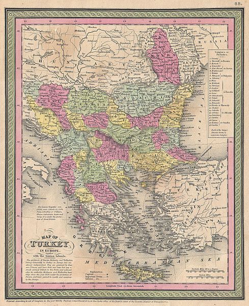
| Samuel Augustus Mitchell: Map of Turkey in Europe together with the Ionian Islands.
( |
||||||||||||||||||||
|---|---|---|---|---|---|---|---|---|---|---|---|---|---|---|---|---|---|---|---|---|
| Autorius |
|
|||||||||||||||||||
| Pavadinimas |
Map of Turkey in Europe together with the Ionian Islands. |
|||||||||||||||||||
| Aprašymas |
English: An extremely attractive example of S. A. Mitchell Sr.’s 1853 map of Turkey in Europe. This map, made when the Ottoman Empire controlled much of the region, covers what is today Turkey, Greece, Macedonia Croatia, Bosnia, Serbia, Romania, Bulgaria, Macedonia and Albania. Ottoman provinces are color coded and numbered. Surrounded by the green border common to Mitchell maps from the 1850s. Prepared by S. A. Mitchell for issued as plate no. 62 in the 1853 edition of his New Universal Atlas . Dated and copyrighted, “Entered according to act of Congress, in the year 1850, by Thomas Cowperthwait & Co., in the Clerks office of the District court of the Eastern District of Pennsylvania. |
|||||||||||||||||||
| Data | 1850 m. (dated) | |||||||||||||||||||
| Matmenys | aukštis: 12,5 in (31,7 cm); plotis: 10 in (25,4 cm) | |||||||||||||||||||
| Leidimo numeris |
Geographicus link: TurkeyEurope-mitchell-1850 |
|||||||||||||||||||
| Šaltinis/Fotografas |
A New Universal Atlas Containing Maps of the various Empires, Kingdoms, States and Republics Of The World. (1853 issue)
|
|||||||||||||||||||
| Leidimas (Šios rinkmenos panaudojimas kitur) |
|
|||||||||||||||||||
Rinkmenos istorija
Paspauskite ant datos/laiko, kad pamatytumėte rinkmeną tokią, kokia ji buvo tuo metu.
| Data/Laikas | Miniatiūra | Matmenys | Naudotojas | Paaiškinimas | |
|---|---|---|---|---|---|
| dabartinis | 13:46, 22 kovo 2011 | | 2 445 × 3 000 (2,91 MiB) | BotMultichillT (aptarimas | indėlis) | {{subst:User:Multichill/Geographicus |link=http://www.geographicus.com/P/AntiqueMap/TurkeyEurope-mitchell-1850 |product_name=1853 Mitchell Map of Turkey in Europe and Greece ( Greece, Balkans, Macedonia ) |map_title=Map of Turkey in Europe together with t |
Jūs negalite perrašyti šios rinkmenos.
Rinkmenos naudojimas
Šis puslapis naudoja šią rinkmeną:
_-_Geographicus_-_TurkeyEurope-mitchell-1850.jpg)
Visuotinis rinkmenos naudojimas
Ši rinkmena naudojama šiose viki svetainėse:
- Naudojama sh.wikipedia.org
_-_Geographicus_-_TurkeyEurope-mitchell-1850.jpg&oldid=745845959)