File:1855 U.S. Coast Survey Chart or Map of the Savanna River, Georgia - Geographicus - SavannahRiver-uscs-1855.jpg
ナビゲーションに移動
検索に移動

このプレビューのサイズ: 800 × 473 ピクセル。 その他の解像度: 320 × 189 ピクセル | 640 × 378 ピクセル | 1,024 × 605 ピクセル | 1,280 × 756 ピクセル | 2,560 × 1,513 ピクセル | 6,000 × 3,545 ピクセル。
元のファイル (6,000 × 3,545 ピクセル、ファイルサイズ: 3.35メガバイト、MIME タイプ: image/jpeg)
キャプション
キャプション
このファイルの内容を1行で記述してください
| (E No. 6) Preliminary Chart of Savannah River Georgia. | ||||||
|---|---|---|---|---|---|---|
| 作者 | ||||||
| タイトル |
(E No. 6) Preliminary Chart of Savannah River Georgia. |
|||||
| 解説 |
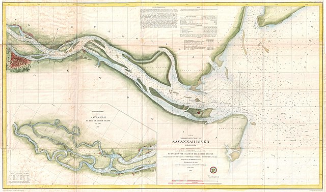
English: This is a very attractive example of the 1855 U.S. Coast Survey nautical chart or map of the Savannah River, Georgia. Centered on Jones Island, this map extends from the river’s mouth at Tybee and Turtle Islands inland as far as the city of Savannah, which is itself drawn in considerable detail. This chart notes Fort Pulaski at the mouth of the river as well as the Fort Jackson and the Union Causeway. The city of Savannah itself is beautifully rendered with its hallmark grid structure and even important buildings and parks clearly in evidence. The lower left quadrant features an inset that continues the map from Savannah westward to Argyle Island. The triangulation for this map was completed by E.O. Cord, C. O. Boutelle, C. P. Bolles and D. T. Van Buren. The topography is the work of H. I. Whiting. The Hydrography was accomplished by a party under the command of J. N. Maffitt. The entire chart was produced under the supervision of A. D. Bache, of the most prolific and influential Superintendents of the U.S. Coast Survey. |
|||||
| 日付 | 1855年 (dated) | |||||
| 寸法 | 高さ: 20 in (50.8 cm);幅: 33 in (83.8 cm) | |||||
| 台帳番号 |
Geographicus link: SavannahRiver-uscs-1855 |
|||||
| 情報源/撮影者 |
Report of the Superintendant of the United States Coast Survey, (Washington) 1855.
|
|||||
| 許可 (ファイルの再利用) |
|
|||||
| 被写体の位置 | | 以下のサービスでこの位置を確認する: オープンストリートマップ |
|---|
| 注釈 | この画像には注釈がついています: コモンズで注釈を見る |
ファイルの履歴
過去の版のファイルを表示するには、その版の日時をクリックしてください。
| 日付と時刻 | サムネイル | 寸法 | 利用者 | コメント | |
|---|---|---|---|---|---|
| 現在の版 | 2011年3月25日 (金) 05:26 | | 6,000 × 3,545 (3.35メガバイト) | BotMultichillT (トーク | 投稿記録) | {{subst:User:Multichill/Geographicus |link=http://www.geographicus.com/P/AntiqueMap/SavannahRiver-uscs-1855 |product_name=1855 U.S. Coast Survey Chart or Map of the Savanna River, Georgia |map_title=(E No. 6) Preliminary Chart of Savannah River Georgia. | |
このファイルは上書きできません。
ファイルの使用状況
以下のページがこのファイルを使用しています:
グローバルなファイル使用状況
以下に挙げる他のウィキがこの画像を使っています:
- en.wikipedia.org での使用状況
- fr.wikipedia.org での使用状況
- ja.wikipedia.org での使用状況