File:1860-61 Secession in Appalachia by County.jpg
跳转到导航
跳转到搜索
本预览的尺寸:473 × 600像素。 其他分辨率:189 × 240像素 | 378 × 480像素 | 606 × 768像素 | 807 × 1,024像素 | 1,887 × 2,393像素。
原始文件 (1,887 × 2,393像素,文件大小:1.82 MB,MIME类型:image/jpeg)
说明
说明
添加一行文字以描述该文件所表现的内容
摘要
[编辑]
| 描述 |
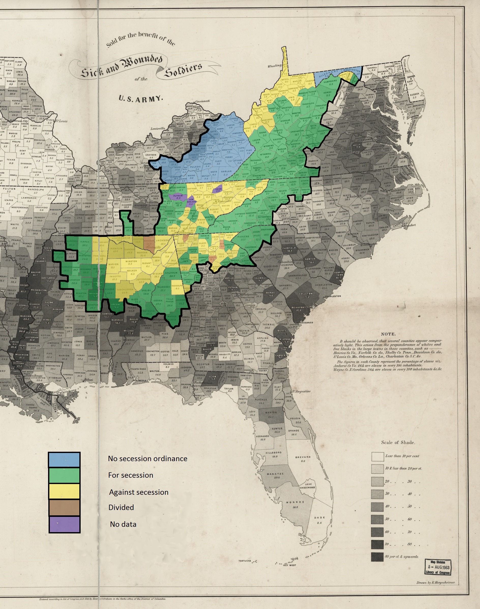
English: This is a map showing the voting in the various county votes of the southern states with boundaries within Appalachia on their states various ordinances of secession from the United States during the secession crisis of 1860-1861. The heavy black outline within the map shows the boundaries of the counties that are within the modern definition of Appalachia as described by the Appalachian Regional Commission. The basic map, showing slaves as a percentage of population, is public domain and was created in 1860 by the United States Coast Survey. |
| 日期 | |
| 来源 | 自己的作品 |
| 作者 | Dubyavee |
许可协议
[编辑]
我,本作品著作权人,特此采用以下许可协议发表本作品:
本文件采用知识共享署名-相同方式共享 4.0 国际许可协议授权。
- 您可以自由地:
- 共享 – 复制、发行并传播本作品
- 修改 – 改编作品
- 惟须遵守下列条件:
- 署名 – 您必须对作品进行署名,提供授权条款的链接,并说明是否对原始内容进行了更改。您可以用任何合理的方式来署名,但不得以任何方式表明许可人认可您或您的使用。
- 相同方式共享 – 如果您再混合、转换或者基于本作品进行创作,您必须以与原先许可协议相同或相兼容的许可协议分发您贡献的作品。
文件历史
点击某个日期/时间查看对应时刻的文件。
| 日期/时间 | 缩略图 | 大小 | 用户 | 备注 | |
|---|---|---|---|---|---|
| 当前 | 2015年3月7日 (六) 03:24 | | 1,887 × 2,393(1.82 MB) | Dubyavee(留言 | 贡献) | User created page with UploadWizard |
您不可以覆盖此文件。
文件用途
没有页面使用本文件。
全域文件用途
以下其他wiki使用此文件:
- en.wikipedia.org上的用途
- hr.wikipedia.org上的用途
- id.wikipedia.org上的用途
- it.wikipedia.org上的用途
- no.wikipedia.org上的用途
- zh.wikipedia.org上的用途
元数据
分类:
- Appalachia
- Slavery in the United States
- Maps of the American Civil War
- Secession in the United States
- North Carolina in the 1860s
- South Carolina in the 1860s
- Tennessee in the 1860s
- Mississippi in the 1860s
- Alabama in the 1860s
- Georgia (U.S. state) in the 1860s
- Old maps of Virginia in the American Civil War
- West Virginia in the 1860s
- Kentucky in the 1860s
- Maryland in the American Civil War
- 1861 maps of the United States
- United States Coast Survey maps
- Maps of the history of West Virginia
- Maps of the history of Tennessee
- Maps of the history of Alabama
- Maps of the history of Virginia
- Maps showing the 1860s