File:1860-61 Secession in Appalachia by County.jpg
跳至導覽
跳至搜尋
預覽大小:473 × 600 像素。 其他解析度:189 × 240 像素 | 378 × 480 像素 | 606 × 768 像素 | 807 × 1,024 像素 | 1,887 × 2,393 像素。
原始檔案 (1,887 × 2,393 像素,檔案大小:1.82 MB,MIME 類型:image/jpeg)
說明
說明
添加單行說明來描述出檔案所代表的內容
摘要
[編輯]
| 描述 |
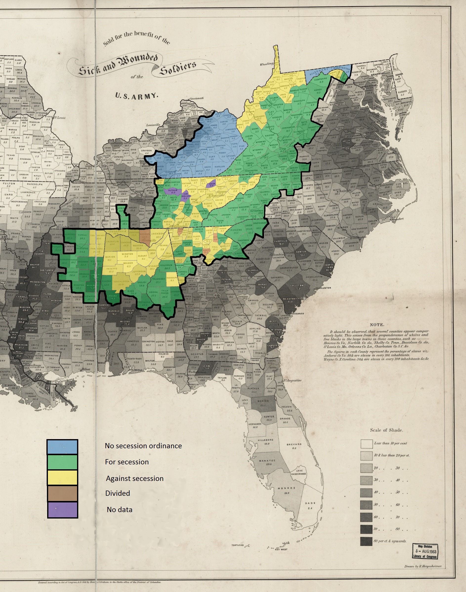
English: This is a map showing the voting in the various county votes of the southern states with boundaries within Appalachia on their states various ordinances of secession from the United States during the secession crisis of 1860-1861. The heavy black outline within the map shows the boundaries of the counties that are within the modern definition of Appalachia as described by the Appalachian Regional Commission. The basic map, showing slaves as a percentage of population, is public domain and was created in 1860 by the United States Coast Survey. |
| 日期 | |
| 來源 | 自己的作品 |
| 作者 | Dubyavee |
授權條款
[編輯]
我,本作品的著作權持有者,決定用以下授權條款發佈本作品:
此檔案採用共享創意 姓名標示-相同方式分享 4.0 國際授權條款。
- 您可以自由:
- 分享 – 複製、發佈和傳播本作品
- 重新修改 – 創作演繹作品
- 惟需遵照下列條件:
- 姓名標示 – 您必須指名出正確的製作者,和提供授權條款的連結,以及表示是否有對內容上做出變更。您可以用任何合理的方式來行動,但不得以任何方式表明授權條款是對您許可或是由您所使用。
- 相同方式分享 – 如果您利用本素材進行再混合、轉換或創作,您必須基於如同原先的相同或兼容的條款,來分布您的貢獻成品。
檔案歷史
點選日期/時間以檢視該時間的檔案版本。
| 日期/時間 | 縮圖 | 尺寸 | 用戶 | 備註 | |
|---|---|---|---|---|---|
| 目前 | 2015年3月7日 (六) 03:24 | | 1,887 × 2,393(1.82 MB) | Dubyavee(對話 | 貢獻) | User created page with UploadWizard |
無法覆蓋此檔案。
檔案用途
沒有使用此檔案的頁面。
全域檔案使用狀況
以下其他 wiki 使用了這個檔案:
- en.wikipedia.org 的使用狀況
- hr.wikipedia.org 的使用狀況
- id.wikipedia.org 的使用狀況
- it.wikipedia.org 的使用狀況
- no.wikipedia.org 的使用狀況
- zh.wikipedia.org 的使用狀況
詮釋資料
分類:
- Appalachia
- Slavery in the United States
- Maps of the American Civil War
- Secession in the United States
- North Carolina in the 1860s
- South Carolina in the 1860s
- Tennessee in the 1860s
- Mississippi in the 1860s
- Alabama in the 1860s
- Georgia (U.S. state) in the 1860s
- Old maps of Virginia in the American Civil War
- West Virginia in the 1860s
- Kentucky in the 1860s
- Maryland in the American Civil War
- 1861 maps of the United States
- United States Coast Survey maps
- Maps of the history of West Virginia
- Maps of the history of Tennessee
- Maps of the history of Alabama
- Maps of the history of Virginia
- Maps showing the 1860s