File:1865 Spruner Map of Germany in Antiquity - Geographicus - Germania-spruner-1865.jpg
Zur Navigation springen
Zur Suche springen

Größe dieser Vorschau: 724 × 600 Pixel. Weitere Auflösungen: 290 × 240 Pixel | 579 × 480 Pixel | 927 × 768 Pixel | 1.236 × 1.024 Pixel | 2.472 × 2.048 Pixel | 3.500 × 2.900 Pixel.
Originaldatei (3.500 × 2.900 Pixel, Dateigröße: 2,28 MB, MIME-Typ: image/jpeg)
Bildtexte
Kurzbeschreibungen
Ergänze eine einzeilige Erklärung, was diese Datei darstellt.
Beschreibung
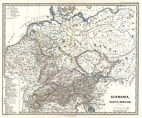
[Bearbeiten]| Karl Spruner von Merz: Germania, Raetia, Noricum.
( |
||||||||||||||||||||
|---|---|---|---|---|---|---|---|---|---|---|---|---|---|---|---|---|---|---|---|---|
| Künstler |
|
|||||||||||||||||||
| Titel |
Germania, Raetia, Noricum. |
|||||||||||||||||||
| Beschreibung |
English: A particularly interesting map, this is Karl von Spruner’s 1865 rendering of Germany (or Germania) in antiquity. Like most of Spruner’s work this example overlays ancient political geographies on relatively contemporary physical geographies, thus identifying the sites of forgotten towns and villages, the movements of armies, and the disposition of lands in the region. This particular map focuses on the regions of Germania Inferior (which was a pacified Roman Province) and the more troublesome Germania Magna (Greater Germany) which resisted all attempts at Roman rule. As a whole the map labels important cities, rivers, mountain ranges and other minor topographical detail. Territories and countries outlined in color. All text is in Latin. The whole is rendered in finely engraved detail exhibiting the fine craftsmanship for which the Perthes firm is known. Of particular interest to classical scholars. |
|||||||||||||||||||
| Datum | 1865 (undated) | |||||||||||||||||||
| Maße | Höhe: 13 in (33 cm); Breite: 16 in (40,6 cm) | |||||||||||||||||||
| Inventarnummer |
Geographicus link: Germania-spruner-1865 |
|||||||||||||||||||
| Herkunft/Fotograf |
Spruner, Karl von, Spruner-Menke Atlas Antiquus,, (Gotha: Justus Perthes), 1865.
|
|||||||||||||||||||
| Genehmigung (Weiternutzung dieser Datei) |
|
|||||||||||||||||||
| Andere Versionen |
|
|||||||||||||||||||

Dateiversionen
Klicke auf einen Zeitpunkt, um diese Version zu laden.
| Version vom | Vorschaubild | Maße | Benutzer | Kommentar | |
|---|---|---|---|---|---|
| aktuell | 06:18, 25. Mär. 2011 | | 3.500 × 2.900 (2,28 MB) | BotMultichillT (Diskussion | Beiträge) | {{subst:User:Multichill/Geographicus |link=http://www.geographicus.com/P/AntiqueMap/Germania-spruner-1865 |product_name=1865 Spruner Map of Germany in Antiquity |map_title=Germania, Raetia, Noricum. |description=A particularly interesting map, this is Kar |
Du kannst diese Datei nicht überschreiben.
Dateiverwendung
Die folgenden 2 Seiten verwenden diese Datei:
Globale Dateiverwendung
Die nachfolgenden anderen Wikis verwenden diese Datei:
- Verwendung auf de.wikipedia.org
- Verwendung auf it.wikipedia.org