File:1878 Government Land Office Map of Lanai, Hawaii - Geographicus - LanaiHawaii-lo-1878.jpg
Originaldatei (4.000 × 3.029 Pixel, Dateigröße: 1,47 MB, MIME-Typ: image/jpeg)
Bildtexte
Kurzbeschreibungen
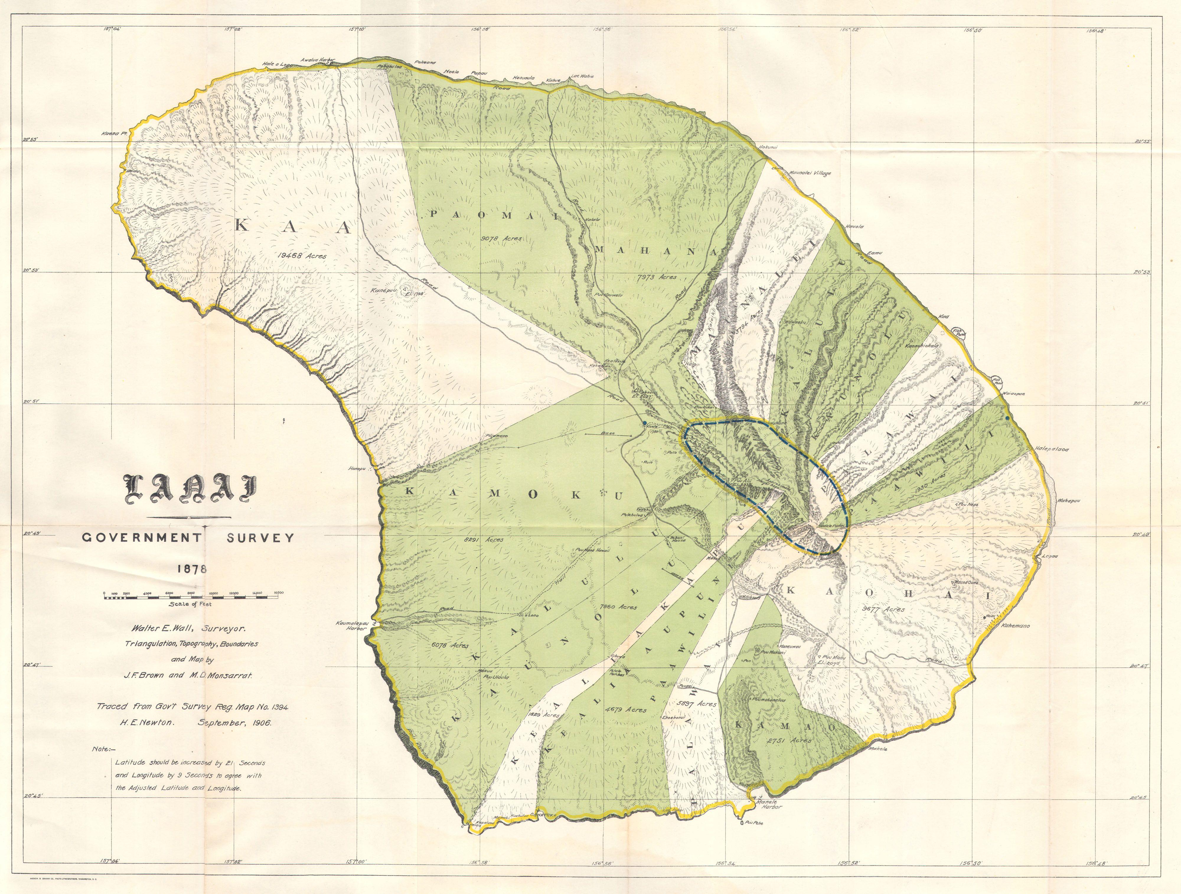
| Lanai Government Survey. | ||||||
|---|---|---|---|---|---|---|
| Künstler | ||||||
| Titel |
Lanai Government Survey. |
|||||
| Beschreibung |
English: This rare and extraordinary 1878 map of the island of Lanai, in the Hawaiian group, was prepared for the 1906 Report of the Governor of the Territory of Hawaii to the Secretary of the Interior. Though the cartographic work that produced this map was started in 1878, during the Hawaiian Monarchy, the map itself, and the report that contained it, was issued following the U.S. Government’s 1898 annexation of the Hawaiian Republic. The Report was an attempt to assess and examine the newly created Hawaiian Territory’s potential for proper administration and development. Consequently the map focuses on Public Lands, Homestead Settlement Tracts, Grazing Lands, Pineapple Lands, Sugar Plantations, Forest Reserves, Forest Lands, Wet Lands, etc. It also features both practical and topographic details for use in administering the region. The governor at this time was George R. Carter. The primary triangulation for this map was accomplished by J. F. Brown and M. D Monsarrat. The survey work was done by Walter E. Wall. This map is heavily based upon the H. E Newton Government Survey Regional Map No. 1394. |
|||||
| Datum | 1878 | |||||
| Maße | Höhe: 19,5 in (49,5 cm); Breite: 26,5 in (67,3 cm) | |||||
| Inventarnummer |
Geographicus link: LanaiHawaii-lo-1878 |
|||||
| Herkunft/Fotograf |
|
|||||
| Genehmigung (Weiternutzung dieser Datei) |
|
|||||
Dateiversionen
Klicke auf einen Zeitpunkt, um diese Version zu laden.
| Version vom | Vorschaubild | Maße | Benutzer | Kommentar | |
|---|---|---|---|---|---|
| aktuell | 16:49, 24. Mär. 2011 | | 4.000 × 3.029 (1,47 MB) | BotMultichillT (Diskussion | Beiträge) | {{subst:User:Multichill/Geographicus |link=http://www.geographicus.com/P/AntiqueMap/LanaiHawaii-lo-1878 |product_name=1878 Government Land Office Map of Lanai, Hawaii |map_title=Lanai Government Survey. |description=This rare and extraordinary 1878 map of |
Du kannst diese Datei nicht überschreiben.
Dateiverwendung
Die folgende Seite verwendet diese Datei:
Globale Dateiverwendung
Die nachfolgenden anderen Wikis verwenden diese Datei: