File:1879 Coney Island.jpg
Jump to navigation
Jump to search

Size of this preview: 800 × 168 pixels. Other resolutions: 320 × 67 pixels | 640 × 134 pixels | 1,024 × 215 pixels | 4,434 × 930 pixels.
Original file (4,434 × 930 pixels, file size: 1.03 MB, MIME type: image/jpeg)
Captions
Captions
Add a one-line explanation of what this file represents
Summary
[edit]
| Description |
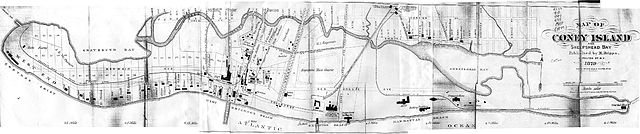
An 1879 map of Coney Island, Brooklyn, New York. New York, USA. This map plots existing property lines and structures from that time period and shows the then still existent "Coney Island Creek'. It also contains an overlay (doted lines) showing a proposed change/expansion of the street "grid" that would follow a planed filling and dredging of Coney Island Creek to make a Gravesend Ship Canal running in an almost straight line east to west. Map stitched together from [1]. |
| Date | /2016/ /1873. :1879 |
| Source | http://www.nycgovparks.org/parks/ |
| Georeferencing | If inappropriate please set warp_status = skip to hide. |
Licensing
[edit]
|
This work is in the public domain in its country of origin and other countries and areas where the copyright term is the author's life plus 70 years or fewer. | |
| This file has been identified as being free of known restrictions under copyright law, including all related and neighboring rights. | |
File history
Click on a date/time to view the file as it appeared at that time.
| Date/Time | Thumbnail | Dimensions | User | Comment | |
|---|---|---|---|---|---|
| current | 14:41, 11 March 2005 | 4,434 × 930 (1.03 MB) | SPUI~commonswiki (talk | contribs) | {{PD}}An 1879 map of Coney Island, Brooklyn, New York. New York, USA. Stitched together from [http://www.bklyn-genealogy-info.com/Map/1873.Coney.html].category:Coney Island, New Yorkcategory:New York City Subway |
You cannot overwrite this file.
File usage on Commons
The following 2 pages use this file:
File usage on other wikis
The following other wikis use this file:
- Usage on de.wikipedia.org
- Usage on en.wikipedia.org
- Usage on es.wikipedia.org
- Usage on ja.wikipedia.org