File:1906 Boatwright intensity.jpg
Aller à la navigation
Aller à la recherche

Taille de cet aperçu : 415 × 599 pixels. Autres résolutions : 166 × 240 pixels | 612 × 884 pixels.
Fichier d’origine (612 × 884 pixels, taille du fichier : 539 kio, type MIME : image/jpeg)
Légendes
Légendes
Ajoutez en une ligne la description de ce que représente ce fichier
Description[modifier]
Public Domain
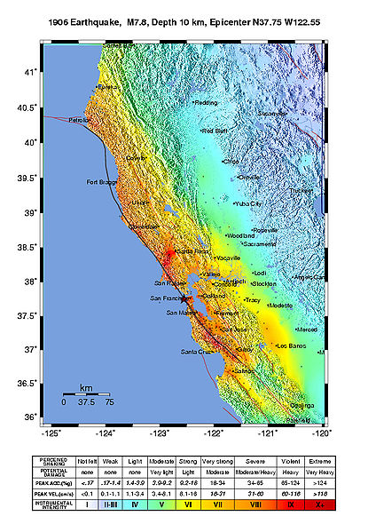
Intensity map for the 1906 San Francisco Earthquake deduced from the Lawson report
from U.S. Geological Survey Open-File Report 2005-1135
Modified Mercalli Intensity Maps for the 1906 San Francisco Earthquake Plotted in ShakeMap Format
By John Boatwright and Howard Bundock
Conditions d’utilisation[modifier]
Cette image est placée dans le domaine public parce qu'elle contient des éléments issus de l'United States Geological Survey, une agence du Département de l'Intérieur des États-Unis. Pour plus d'information, consultez la politique officielle de copyright de l'USGS (en anglais)
|
Historique du fichier
Cliquer sur une date et heure pour voir le fichier tel qu'il était à ce moment-là.
| Date et heure | Vignette | Dimensions | Utilisateur | Commentaire | |
|---|---|---|---|---|---|
| actuel | 30 mai 2006 à 21:45 | | 612 × 884 (539 kio) | Andre315 (d | contributions) | Public Domain<br/> Intensity map for the 1906 San Francisco Earthquake deduced from the Lawson report<br/> from U.S. Geological Survey Open-File Report 2005-1135<br/> Modified Mercalli Intensity Maps for the 1906 San Francisco Earthquake Plotted in ShakeM |
Vous ne pouvez pas remplacer ce fichier.
Utilisations locales du fichier
La page suivante utilise ce fichier :
Utilisations du fichier sur d’autres wikis
Les autres wikis suivants utilisent ce fichier :
- Utilisation sur cs.wikipedia.org
- Utilisation sur de.wikipedia.org
- Utilisation sur en.wikipedia.org
- Utilisation sur fr.wikipedia.org
- Utilisation sur gl.wikipedia.org
- Utilisation sur hu.wikipedia.org
- Utilisation sur ka.wikipedia.org
- Utilisation sur ko.wikipedia.org
- Utilisation sur ms.wikipedia.org
- Utilisation sur nl.wikipedia.org
- Utilisation sur tr.wikipedia.org