File:1912 China map from National Geographic.jpg
পরিভ্রমণে চলুন
অনুসন্ধানে চলুন

এই প্রাকদর্শনের আকার: ৭৮৬ × ৬০০ পিক্সেল। অন্যান্য আকারসমূহ: ৩১৫ × ২৪০ পিক্সেল | ৬২৯ × ৪৮০ পিক্সেল | ১,০০৭ × ৭৬৮ পিক্সেল | ১,২৮০ × ৯৭৭ পিক্সেল | ২,৫৬০ × ১,৯৫৩ পিক্সেল | ৬,৯৮০ × ৫,৩২৬ পিক্সেল।
মূল ফাইল (৬,৯৮০ × ৫,৩২৬ পিক্সেল, ফাইলের আকার: ১০.৬৫ মেগাবাইট, এমআইএমই ধরন: image/jpeg)
ক্যাপশনসমূহ
ক্যাপশন
এই ফাইল কি প্রতিনিধিত্ব করছে তার এক লাইন ব্যাখ্যা যোগ করুন
সারাংশ[সম্পাদনা]
| বর্ণনা |
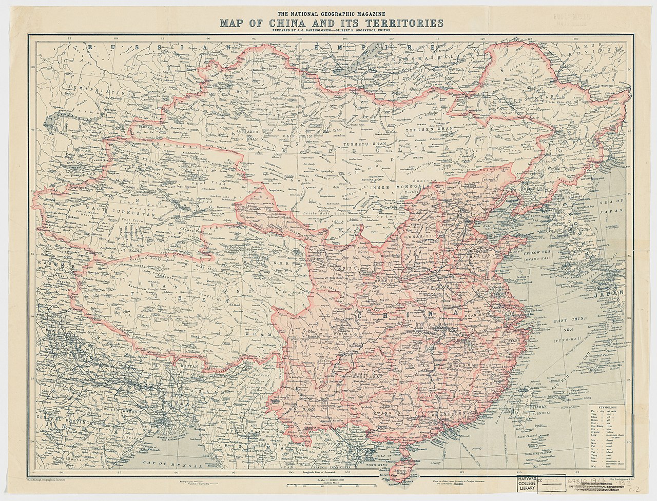
English: The National Geographic Magazine map of China and its territories
中文(中国大陆):中国地图,出自1912年10月美国《國家地理雜誌》 |
||||||||||||||||||||
| তারিখ | |||||||||||||||||||||
| উৎস |
Harvard University Library 1912年10月國家地理雜誌 |
||||||||||||||||||||
| স্রষ্টা |
Edinburgh Geographical Institute |
||||||||||||||||||||
| অনুমতি (এ ফাইলের পুনঃব্যবহার) |
|
||||||||||||||||||||
| Warper-এ মানচিত্রের আস্তরণ | If inappropriate please set warp_status = skip to hide. | ||||||||||||||||||||
| অন্যান্য সংস্করণ | Digital Commonwealth | ||||||||||||||||||||

.jpg)
| Annotations | This image is annotated: View the annotations at Commons |
ফাইলের ইতিহাস
যেকোনো তারিখ/সময়ে ক্লিক করে দেখুন ফাইলটি তখন কী অবস্থায় ছিল।
| তারিখ/সময় | সংক্ষেপচিত্র | মাত্রা | ব্যবহারকারী | মন্তব্য | |
|---|---|---|---|---|---|
| বর্তমান | ২৩:৫০, ১৭ ফেব্রুয়ারি ২০১৫ | | ৬,৯৮০ × ৫,৩২৬ (১০.৬৫ মেগাবাইট) | Scewing (আলোচনা | অবদান) | Higher resolution |
| ০৩:০১, ২০ মে ২০১৪ |  | ১,৬০০ × ১,২১২ (৭৪৬ কিলোবাইট) | Jindaihua (আলোচনা | অবদান) | User created page with UploadWizard |
আপনি এই ফাইলটি প্রতিস্থাপন করতে পারবেন না।
ফাইলের ব্যবহার
নিম্নলিখিত 3টি পাতা এই ফাইল ব্যবহার করে:
ফাইলের বৈশ্বিক ব্যবহার
নিচের অন্যান্য উইকিগুলো এই ফাইলটি ব্যবহার করে:
- bn.wikipedia.org-এ ব্যবহার
- ca.wikipedia.org-এ ব্যবহার
- en.wikipedia.org-এ ব্যবহার
- en.wiktionary.org-এ ব্যবহার
- es.wikipedia.org-এ ব্যবহার
- fr.wikipedia.org-এ ব্যবহার
- lv.wikipedia.org-এ ব্যবহার
- mn.wikipedia.org-এ ব্যবহার
- nl.wikipedia.org-এ ব্যবহার
- pt.wikipedia.org-এ ব্যবহার
- ru.wikipedia.org-এ ব্যবহার
- sr.wikipedia.org-এ ব্যবহার
- zh.wikipedia.org-এ ব্যবহার
অধি-উপাত্ত
বিষয়শ্রেণীসমূহ:
- National Geographic Maps
- National Geographic Magazine, 1912
- 1912 maps of China
- 1912 in Tibet
- Beiyang Government
- China proper
- Maps of Amdo
- Maps of Kham
- Ü-Tsang
- Changtang
- Old maps of the Qing Dynasty
- 20th-century maps of Tibet
- Old maps of Kashmir
- Old maps of Bhutan
- 20th-century maps of Nepal
- Old maps of Myanmar
- Old maps of Bengal
- Old maps of Mongolia
- 20th-century maps of India
- 1910s maps of Korea
- Maps of the Russian Empire
- Old maps of Gansu
- Maps of East Turkestan
- Old maps of Sikkim
- Maps of the Himalayas
- Maps of the Mekong
- Maps of the Salween River
- Maps of the Yellow River
- Maps of the Yangtze River
- Kunlun Mountains
- Yamdrok Lake
- Lake Baikal
- Lake Balkhash
- Qinghai Lake
- Edinburgh Geographical Institute
- John George Bartholomew
- John Bartholomew and Son
- Rima, Tibet
- Chinese postal maps