File:1920 Helsinki tram map.png
Jump to navigation
Jump to search

Size of this preview: 628 × 600 pixels. Other resolutions: 251 × 240 pixels | 502 × 480 pixels | 804 × 768 pixels | 1,256 × 1,200 pixels.
Original file (1,256 × 1,200 pixels, file size: 85 KB, MIME type: image/png)
Captions
Captions
Add a one-line explanation of what this file represents
Summary[edit]
| Description |
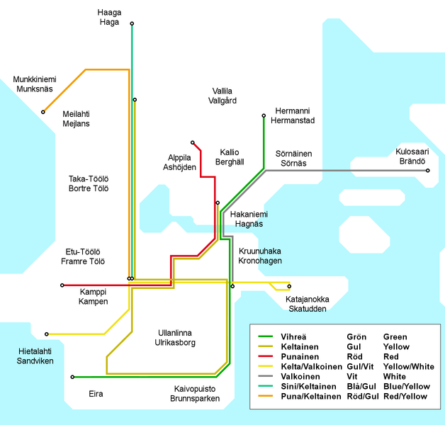
English: Map of the Helsinki tram network as it appeared in 1920-1922. At this time lines were identified solely by their colour combinations and had no numbers or letters as identifiers. The colours used on this map do not wholly match the original colours, in order to maintain the colours as identifiers of the same lines for all the historical Helsinki tram maps.
Suomi: Helsingin raitoteiden linjakartta sellaisena, kuin se oli vuosina 1920-1922. Ennen vuotta 1926 linjoilla ei ollut numero- tai kirjaintunnuksia, vaan ainoastaan värilliset tunnuskilvet. Tämän kartan linjavärit eivät täysin vastaa alkuperäisiä, vaan värit ovat samat kuin muissa Helsingin raitiotieverkon vaiheita käsittelevissä kartoissa.
Svenska: Kartan över Helsingfors spårvägsnätet 1920-1922. Före 1926 spårvägslinjer i Helsingors hade ingen nummer- eller bokstavidentifiering, bara linjefärger. Linjefärger i denna karta är inte precis de samma som orignalfärgerna. |
| Date | |
| Source | Own work |
| Author | Kalle Id |

|
This rail transport map image could be re-created using vector graphics as an SVG file. This has several advantages; see Commons:Media for cleanup for more information. If an SVG form of this image is available, please upload it and afterwards replace this template with
{{vector version available|new image name}}.
It is recommended to name the SVG file “1920 Helsinki tram map.svg”—then the template Vector version available (or Vva) does not need the new image name parameter. |
Licensing[edit]
I, the copyright holder of this work, hereby publish it under the following license:
This file is licensed under the Creative Commons Attribution-Share Alike 3.0 Unported license.
- You are free:
- to share – to copy, distribute and transmit the work
- to remix – to adapt the work
- Under the following conditions:
- attribution – You must give appropriate credit, provide a link to the license, and indicate if changes were made. You may do so in any reasonable manner, but not in any way that suggests the licensor endorses you or your use.
- share alike – If you remix, transform, or build upon the material, you must distribute your contributions under the same or compatible license as the original.
File history
Click on a date/time to view the file as it appeared at that time.
| Date/Time | Thumbnail | Dimensions | User | Comment | |
|---|---|---|---|---|---|
| current | 12:12, 30 June 2010 | | 1,256 × 1,200 (85 KB) | Kjet (talk | contribs) | Bilingual district names, trilingual line identifiers, altered colours to better match the original, improveed grographical accuracy. |
| 16:39, 18 October 2008 |  | 1,256 × 1,200 (53 KB) | Kjet (talk | contribs) | {{Information |Description={{en|1=Map of the Helsinki tram network as it appeared in 1920-1922. At this time lines were identified solely by their colour combinations and had no numbers or letters as identifiers. The colours used on this map do not wholly |
You cannot overwrite this file.
File usage on Commons
There are no pages that use this file.
File usage on other wikis
The following other wikis use this file:
- Usage on en.wikipedia.org
- Usage on fi.wikipedia.org
- Usage on fr.wikipedia.org
- Usage on uk.wikipedia.org