File:1920年代左右台南神社地圖 (含北白川宮御遺跡所).JPG
Jump to navigation
Jump to search

Size of this preview: 800 × 600 pixels. Other resolutions: 320 × 240 pixels | 640 × 480 pixels | 1,024 × 768 pixels | 1,280 × 960 pixels | 2,560 × 1,920 pixels | 3,648 × 2,736 pixels.
Original file (3,648 × 2,736 pixels, file size: 3.11 MB, MIME type: image/jpeg)
Captions
Captions
Add a one-line explanation of what this file represents
Summary
[edit].JPG&action=edit§ion=1)
| Description |
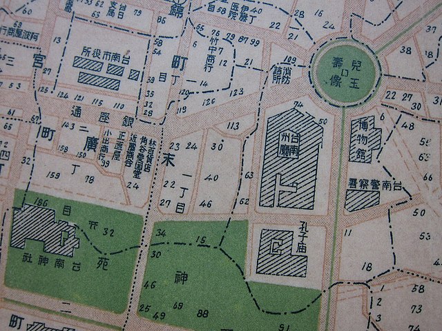
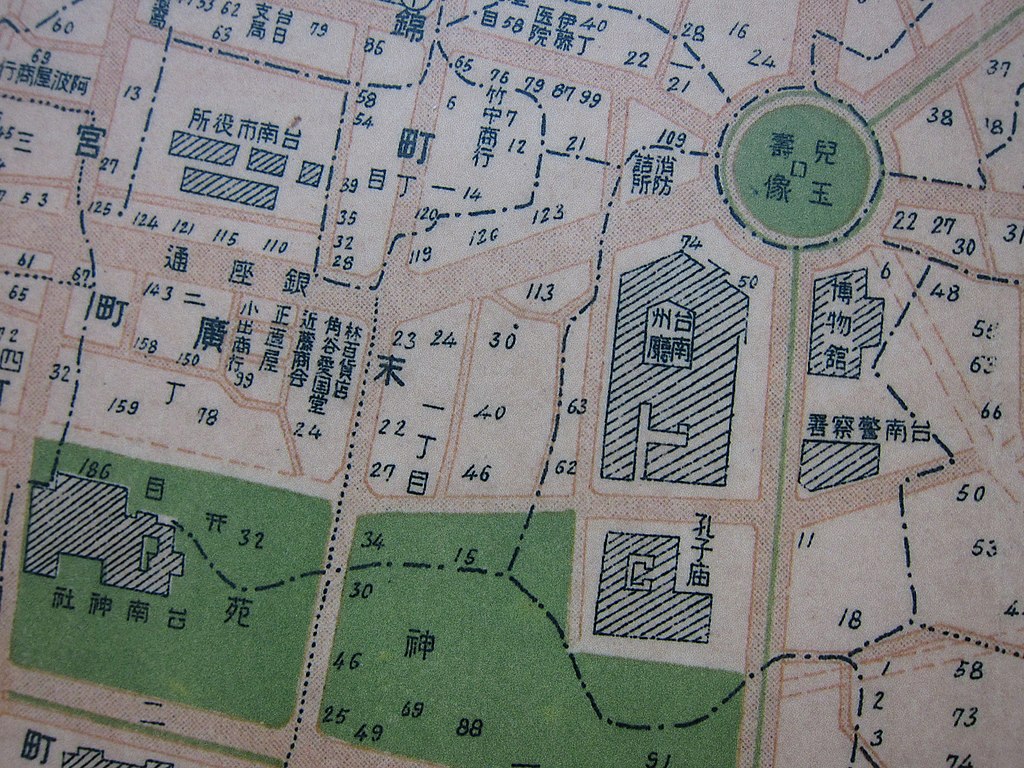
中文(臺灣):台南神社1920年代左右全區配置圖(北面為圖面上方),神社四周圍分別為東邊今南門路,北邊今友愛街、南邊今府前路、西邊今永福路,兩塊綠地中間道路為今忠義路。左邊綠地為台南神社內苑(今第11號公園及地下停車場),右邊綠地為神社外苑及孔子廟(今忠義國小校舍及操場),日本神社內苑通常為祭祀空間,外苑則作為國民休閒娛樂或鍛鍊體魄的空間,後來建於孔廟西側的武德殿即建於本區。
神社南苑西南角原吳汝祥宅(座東朝西面向磚雅橋街,今永福路),後因北百川宮親王死於宅第南側屋舍,日本政府將其去世寢殿闢為「御遺跡所」並陸續增添神門、拜殿、圍籬等設施,範圍大約是里民活動中心及實踐堂範圍,整體建築軸線為座北朝南(面向今府前路)。1920年代以後在御遺跡所東側闢建台南神社,並於1923年落成,增建鳥居、參道、石燈籠、社務所、拜殿、神明造樣式神社等,整體配置改為座西朝東(面向今忠義路)。 |
| Date | 9 March 2011 (original upload date) |
| Source | 翻拍舊地圖照片;Transferred from zh.wikipedia; transferred to Commons by User:Pbdragonwang using CommonsHelper. |
| Author | ENCOLPIUS;Original uploader was Encolpius at zh.wikipedia |
| Permission (Reusing this file) |
PD-TAIWAN. |
Licensing
[edit].JPG&action=edit§ion=2)
| This file is now in the public domain in the Republic of China (Taiwan) because its term of copyright has expired there. According to articles 30 to 34 of the copyright laws of R.O.C., under the jurisdiction of the Government of R.O.C. all non-photographic works enter the public domain 50 years after the death of the creator (there being multiple creators, the creator who dies last) or 50 years after publication for anonymous or pseudonymous authors or for works whose copyright holder is an organization; photographic works enter the public domain 50 years after the public release.
This work is in the public domain in the United States, because it was published before January 1, 1929. |

|
Original upload log
[edit].JPG&action=edit§ion=3)
The original description page was here. All following user names refer to zh.wikipedia.
- 2011-03-09 14:08 Encolpius 3648×2736× (3261413 bytes) {{Information |Description= 台南神社1920年代左右全區配置圖(北面為圖面上方),神社四周圍分別為東邊今南門路,北邊今友愛街、南邊今午前路、西邊今永福路,兩塊綠地中間道路為今忠義路。左�
File history
Click on a date/time to view the file as it appeared at that time.
| Date/Time | Thumbnail | Dimensions | User | Comment | |
|---|---|---|---|---|---|
| current | 14:26, 21 March 2011 | | 3,648 × 2,736 (3.11 MB) | Pbdragonwang (talk | contribs) | {{Information |Description={{zh-tw|台南神社1920年代左右全區配置圖(北面為圖面上方),神社四周圍分別為東邊今南門路,北邊今友愛街、南邊今府前路、西邊今永福路,兩塊綠地中間道路為今忠義路 |
You cannot overwrite this file.
File usage on Commons
There are no pages that use this file.
File usage on other wikis
The following other wikis use this file:
.JPG&oldid=817688461)