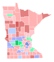
File:1930 United States Senate election in Minnesota results map by county.svg

Original file (SVG file, nominally 744 × 744 pixels, file size: 281 KB)
Captions
Captions
Summary[edit]
| Description1930 United States Senate election in Minnesota results map by county.svg |
English: Map of 1930 US Senate Election in Minnesota shaded by winning percentage. |
| Date | |
| Source | Own work |
| Author | SpeedMcCool |
| This file has been created using a standardized map of a state's counties: Minnesota county map, cb 500k.svg. A full list of available maps exists at Category:Standardized SVG county maps of US states. |
 |
Licensing[edit]
| This file is made available under the Creative Commons CC0 1.0 Universal Public Domain Dedication. | |
| The person who associated a work with this deed has dedicated the work to the public domain by waiving all of their rights to the work worldwide under copyright law, including all related and neighboring rights, to the extent allowed by law. You can copy, modify, distribute and perform the work, even for commercial purposes, all without asking permission.
http://creativecommons.org/publicdomain/zero/1.0/deed.enCC0Creative Commons Zero, Public Domain Dedicationfalsefalse |
File history
Click on a date/time to view the file as it appeared at that time.
| Date/Time | Thumbnail | Dimensions | User | Comment | |
|---|---|---|---|---|---|
| current | 04:31, 11 April 2021 |  | 744 × 744 (281 KB) | Elli (talk | contribs) | fix thumbnailing |
| 09:46, 2 April 2021 |  | 744 × 744 (258 KB) | Elli (talk | contribs) | fix stevens co | |
| 09:45, 2 April 2021 |  | 744 × 744 (258 KB) | Elli (talk | contribs) | change farmer-labor color scheme | |
| 05:09, 2 April 2021 |  | 744 × 744 (258 KB) | Awmcphee (talk | contribs) | New shapes | |
| 15:45, 27 March 2021 |  | 289 × 324 (1.81 MB) | SpeedMcCool (talk | contribs) | While I appreciate the new shapes, they are inconsistent with the vast majority of MN maps. Unless you plan on updating them all, please use the standard shapes. | |
| 16:16, 26 March 2021 |  | 744 × 744 (319 KB) | Elli (talk | contribs) | new shapes and colors | |
| 19:40, 30 August 2018 |  | 289 × 324 (1.81 MB) | SpeedMcCool (talk | contribs) | User created page with UploadWizard |
You cannot overwrite this file.
File usage on Commons
The following 4 pages use this file:
File usage on other wikis
The following other wikis use this file:
- Usage on en.wikipedia.org
Metadata
This file contains additional information such as Exif metadata which may have been added by the digital camera, scanner, or software program used to create or digitize it. If the file has been modified from its original state, some details such as the timestamp may not fully reflect those of the original file. The timestamp is only as accurate as the clock in the camera, and it may be completely wrong.
| Width | 209.97mm |
|---|---|
| Height | 209.97mm |