File:1939 Showa 14 Panorama Map of Diamond Mountain, Kumgangsan, Korea - Geographicus - DiamondMountain-showa14-1939.jpg
ナビゲーションに移動
検索に移動
このプレビューのサイズ: 799 × 260 ピクセル。 その他の解像度: 320 × 104 ピクセル | 640 × 208 ピクセル | 1,024 × 333 ピクセル | 1,280 × 417 ピクセル | 4,000 × 1,302 ピクセル。
元のファイル (4,000 × 1,302 ピクセル、ファイルサイズ: 1.5メガバイト、MIME タイプ: image/jpeg)
キャプション
キャプション
このファイルの内容を1行で記述してください
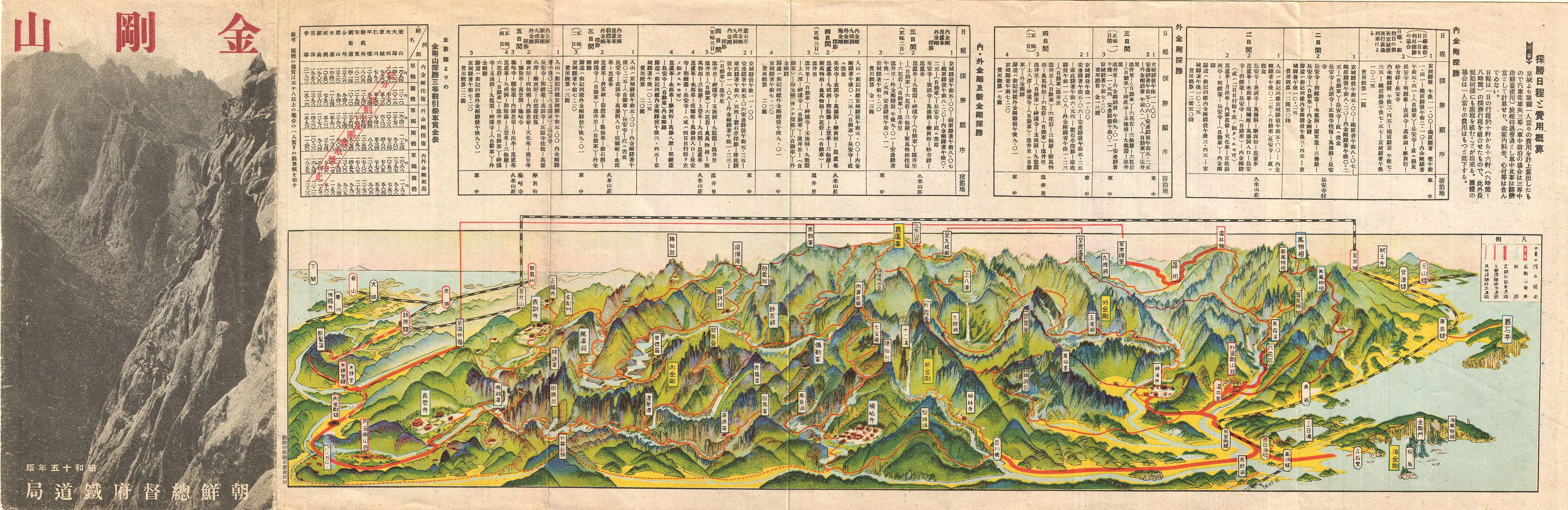
| Kumgangsan. | ||||||
|---|---|---|---|---|---|---|
| 作者 | ||||||
| タイトル |
Kumgangsan. |
|||||
| 解説 |
English: An extremely attractive 1939 or Showa 14 panoramic view map of Kumgangsan or Diamond Mountain, North Korea. Also known as Mount Kumgang, Diamond Mountain is an important tourist destination in North Korea. Diamond Mountain is one of the few areas in North Korea that is open to foreign tourism and regularly visited by international travelers. The mountain is known for is dramatic views and stunning natural beauty. This uncommon type of map evolved out of traditional Japanese view-style cartography and began to appear in Japan, Taiwan, and Korea in the early 20th century. Generally speaking such maps coincided with the development of railroad lines throughout the once vast Dai Nippon Teikoku or Japanese Empire. It is a distinctive style full of artistic flourish that at the same time performs a practical function. This particular example is both relatively early and exceptionally beautiful. It was printed via a multi-color lithographic process with delicately shaded tones and a easily comprehensible intuitive design. Shows villages, famous sights, roadways, and rail lines. Folds into itself, accordion style, with an photographic cover depicting Diamond Mountain at the left end. Verso features additional Japanese text and a smaller transportation map. |
|||||
| 日付 | 1939年 or Showa 14 | |||||
| 寸法 | 高さ: 7 in (17.7 cm);幅: 21 in (53.3 cm) | |||||
| 台帳番号 |
Geographicus link: DiamondMountain-showa14-1939 |
|||||
| 情報源/撮影者 |
|
|||||
| 許可 (ファイルの再利用) |
|
|||||
| その他のバージョン | ||||||
| 被写体の位置 | | 以下のサービスでこの位置を確認する: オープンストリートマップ |
|---|
ファイルの履歴
過去の版のファイルを表示するには、その版の日時をクリックしてください。
| 日付と時刻 | サムネイル | 寸法 | 利用者 | コメント | |
|---|---|---|---|---|---|
| 現在の版 | 2011年3月24日 (木) 02:41 | 4,000 × 1,302 (1.5メガバイト) | BotMultichillT (トーク | 投稿記録) | {{subst:User:Multichill/Geographicus |link=http://www.geographicus.com/P/AntiqueMap/DiamondMountain-showa14-1939 |product_name=1939 Showa 14 Panorama Map of Diamond Mountain, Kumgangsan, Korea |map_title=Kumgangsan. |description=An extremely attractive 1 |
このファイルは上書きできません。
ファイルの使用状況
以下の 3 ページがこのファイルを使用しています:
グローバルなファイル使用状況
以下に挙げる他のウィキがこの画像を使っています:
- en.wikipedia.org での使用状況
- en.wikiquote.org での使用状況
- fr.wikipedia.org での使用状況
- ja.wikipedia.org での使用状況
- ka.wikipedia.org での使用状況
- tl.wikipedia.org での使用状況
- uk.wikipedia.org での使用状況