File:1943 World War II Japanese Aeronautical Map of Borneo - Geographicus - Borneo12-wwii-1943.jpg
跳至導覽
跳至搜尋

預覽大小:800 × 544 像素。 其他解析度:320 × 217 像素 | 640 × 435 像素 | 1,024 × 696 像素 | 1,280 × 870 像素 | 2,560 × 1,739 像素 | 5,000 × 3,397 像素。
原始檔案 (5,000 × 3,397 像素,檔案大小:5.27 MB,MIME 類型:image/jpeg)
說明
說明
添加單行說明來描述出檔案所代表的內容
| Borneo | |||||
|---|---|---|---|---|---|
| 作家 | |||||
| 標題 |
Borneo |
||||
| 描述 |
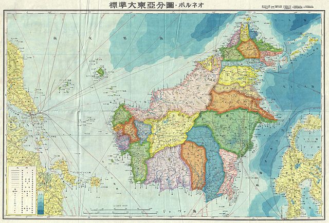
English: A stunning large format Japanese map of Borneo dating to World War II. Covers the entirety of the island with color coding according to district. Offers superb detail regarding both topographical and political elements. Notes cities, roads, trade routes on air, sea and land, and uses shading to display oceanic depths. All text in Japanese. While Allied World War II maps of this region are fairly common it is extremely rare to come across their Japanese counterparts. This map was created as map no. 12 of a 20 map series detailing of parts of Asia and the Pacific prepared by the Japanese during World War II. |
||||
| 日期 | 1943年 (undated) | ||||
| 尺寸 | 高度:20英寸(50.8釐米);寬度:29英寸(73.6釐米) | ||||
| 登錄號 |
Geographicus link: Borneo12-wwii-1943 |
||||
| 來源/攝影者 |
|
||||
| 授權許可 (重用此檔案) |
|
||||

檔案歷史
點選日期/時間以檢視該時間的檔案版本。
| 日期/時間 | 縮圖 | 尺寸 | 用戶 | 備註 | |
|---|---|---|---|---|---|
| 目前 | 2011年3月22日 (二) 16:50 | | 5,000 × 3,397(5.27 MB) | BotMultichillT(對話 | 貢獻) | {{subst:User:Multichill/Geographicus |link=http://www.geographicus.com/P/AntiqueMap/Borneo12-wwii-1943 |product_name=1943 World War II Japanese Aeronautical Map of Borneo |map_title=Borneo |description=A stunning large format Japanese map of Borneo dating |
無法覆蓋此檔案。
檔案用途
下列2個頁面有用到此檔案:
全域檔案使用狀況
以下其他 wiki 使用了這個檔案:
- ar.wikipedia.org 的使用狀況
- el.wikipedia.org 的使用狀況
- en.wikipedia.org 的使用狀況
- es.wikipedia.org 的使用狀況
- fa.wikipedia.org 的使用狀況
- fr.wikipedia.org 的使用狀況
- id.wikipedia.org 的使用狀況
- ja.wikipedia.org 的使用狀況
- ms.wikipedia.org 的使用狀況
- my.wikipedia.org 的使用狀況
- ru.wikipedia.org 的使用狀況
- ta.wikipedia.org 的使用狀況
- www.wikidata.org 的使用狀況
- zh.wikipedia.org 的使用狀況